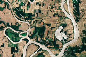
Acquired June 23, 2011, this natural-color image shows the Wabash-Ohio confluence after 2011 spring floods retreated.
Published Jul 3, 2011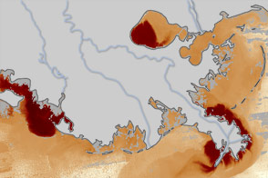
These maps illustrate how much sediment flowed into the Gulf of Mexico during the floods on the Mississippi River in May and June 2011. The nutrient-rich sediment is expected to contribute to the development of a record dead zone this summer.
Published Jun 24, 2011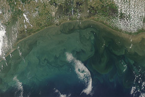
Acquired May 17, 2011, and May 22, 2011, these natural-color images show sediment in the Gulf of Mexico, one consequence of Mississippi River flooding.
Published Jun 23, 2011
These false-color images compare conditions along the Mississippi and Yazoo Rivers around Vicksburg in June 2011, during heavy flooding, and three years earlier.
Published Jun 14, 2011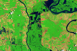
These false-color images compare conditions along the Mississippi River and Atchafalaya Basin in June 2011, during heavy flooding, and three years earlier.
Published Jun 13, 2011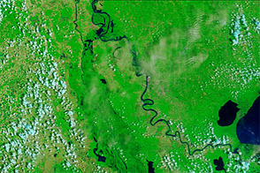
Acquired June 8, 2011, and June 9, 2010, these false-color images compare conditions along the Mississippi and Atchafalaya Rivers in Louisiana.
Published Jun 9, 2011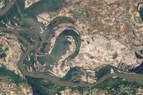
Acquired May 3, 2011, and June 4, 2011, these natural-color images show the Birds Point-New Madrid Floodway after the floodway was opened, and after flood waters receded.
Published Jun 7, 2011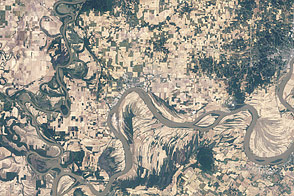
Acquired June 4, 2011, and May 3, 2011, these natural-color images compare flooded and post-flood conditions at the confluence of the Wabash and Ohio Rivers.
Published Jun 7, 2011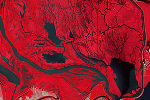
In this false-color image of the flood plains above Morgan City, Louisiana, there are tell-tale signs of floodwater from the Morganza Spillway.
Published Jun 5, 2011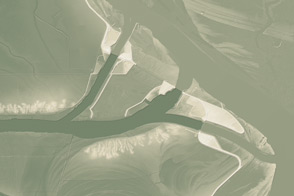
This model of the land elevation between the Mississippi, the Atchafalaya, and the Old River show the uphill fight to control river flow.
Published Jun 4, 2011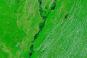
Acquired June 1, 2011, and May 28, 2010, these false-color images compare conditions along the Lower Mississippi River.
Published Jun 1, 2011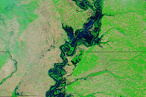
Acquired May 20, 2011, and April 14, 2011, these false-color images show water levels along the Mississippi River.
Published May 23, 2011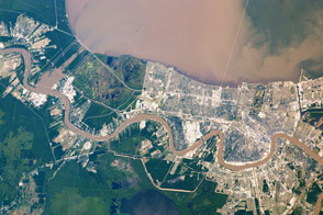
Taken May 17, 2011, this astronaut photograph shows a plume of thick sediment in Lake Pontchartrain, delivered through the Bonnet Carré Spillway.
Published May 20, 2011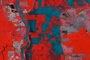
The ASTER instrument on NASA’s Terra satellite captured this false-color image of the Morganza Floodway on May 18, 2011.
Published May 20, 2011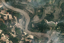
Acquired May 18, 2011, this natural-color image shows flooding along the Mississippi and Yazoo Rivers near Vicksburg, Mississippi.
Published May 19, 2011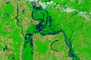
Acquired May 18, 2011, and May 4, 2011, these false-color images show flooded conditions along the Lower Mississippi River, including diverted water entering the Morganza Floodway on May 18.
Published May 18, 2011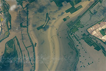
Taken May 12, 2011, this astronaut photograph shows flooding near New Madrid, Missouri.
Published May 17, 2011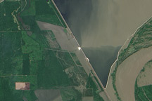
This image from the Advanced Land Imager on NASA's Earth Observing-1 satellite was acquired on May 15, 2011, about 24 hours after the Morganza Spillway was partially opened by the U.S. Army Corps of Engineers to ease flooding along the Mississippi River.
Published May 17, 2011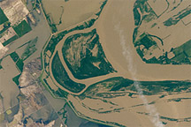
Taken May 12, 2011, this astronaut photograph shows flooding of the Mississippi River along the border between Tennessee and southeastern Missouri.
Published May 16, 2011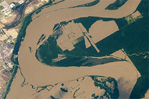
Taken May 12, 2011, this astronaut photograph shows flooding of the Mississippi River around Tomato, Arkansas.
Published May 16, 2011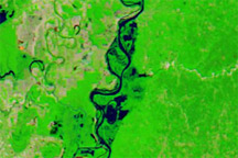
Acquired May 15, 2011, April 29, 2011, and May 4, 2010, these false-color images show conditions along the Lower Mississippi River.
Published May 16, 2011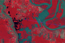
Observations by Landsat 1 from 1973 show the Morganza Floodway after its first and only opening in 57 years.
Published May 14, 2011
Acquired May 11, 2011, and April 21, 2007, these false-color images show the Mississippi River near Natchez, Mississippi. The image from May 2011 shows flooded conditions.
Published May 13, 2011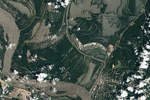
The Mississippi River is rising around Vicksburg, Mississippi, in this image taken on May 10, 2011.
Published May 11, 2011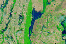
Acquired May 10, 2011, and April 29, 2011, these false-color images show growing floods west of the Mississippi River.
Published May 11, 2011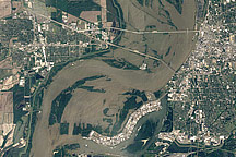
Acquired May 10, 2011, and April 21, 2010, these natural-color images show flooded and normal conditions along the Mississippi River in Memphis, Tennessee.
Published May 11, 2011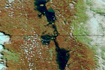
Acquired May 7, 2011, and May 14, 2010, these false-color images compare conditions along the Red River of the North.
Published May 10, 2011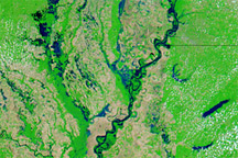
Acquired May 8, 2011, April 29, 2011, and May 3, 2010, these false-color images show water levels along the Mississippi River between Memphis and Vicksburg.
Published May 9, 2011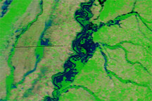
Acquired May 8, 2011, and April 29, 2011, these false-color images show rising water levels along the Mississippi River.
Published May 8, 2011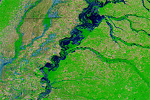
Acquired May 5, 2011, and May 5, 2010, these false-color images compared flood conditions in 2011 to calmer conditions one year earlier.
Published May 7, 2011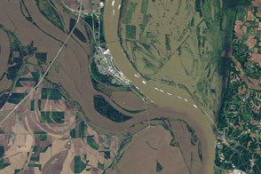
Floods blanket farmland around the confluence of the Ohio and Mississippi Rivers in this Landsat image from May 3, 2011.
Published May 6, 2011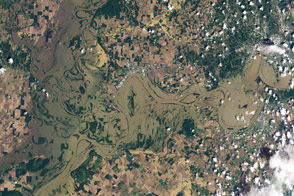
Acquired May 3, 2011, and April 14, 2010, these natural-color images show the confluence of the Wabash and Ohio Rivers.
Published May 5, 2011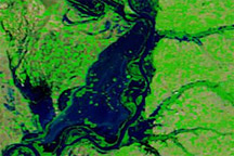
Acquired may 4, 2011, April 29, 2011, and April 29, 2010, these false-color images show the confluence of the Ohio and Mississippi Rivers.
Published May 4, 2011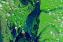
Acquired May 3, 2011, and April 29, 2011, these false-color images show the confluence of the Ohio and Mississippi Rivers before and after the destruction of a levee.
Published May 4, 2011
Acquired May 1, 2011, this natural-color image shows the James River completely filling the river valley near Jamesville, South Dakota.
Published May 3, 2011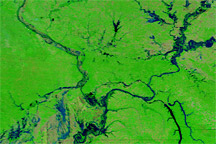
Acquired April 29, 2011, and April 29, 2010, these false-color images demonstrate worse springtime flooding conditions in 2011.
Published May 1, 2011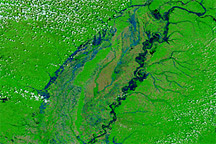
Acquired April 28, 2011, and April 29, 2010, these false-color images compare spring flooding conditions.
Published Apr 28, 2011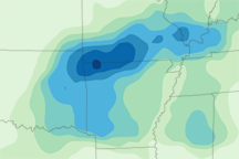
This map depicts rainfall for the Midwestern U.S. from April 19 to 25, 2011, when severe rains added to spring melt to bring dozens of rivers above flood stage.
Published Apr 27, 2011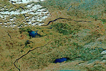
Acquired April 24, 2011, and April 4, 2011, these false-color images show melting snow and rising waters in Manitoba.
Published Apr 25, 2011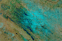
Acquired April 21, 2011, and April 21, 2010, these false-color images show widely diverging snowmelt and flooding conditions in Saskatchewan.
Published Apr 22, 2011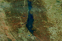
Acquired April 14, 2011, and March 18, 2011, these false-color images show conditions along the Red River in North Dakota, Minnesota, and Manitoba.
Published Apr 18, 2011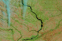
Acquired April 12, 2011, and March 2, 2011, these false-color images show retreating snows and rising rivers in the U.S. Midwest.
Published Apr 14, 2011
Acquired April 6, 2011, March 18, 2011, and March 7, 2011, these false-color images show melting snow and rising water levels in North Dakota, South Dakota, and Minnesota.
Published Apr 11, 2011
The Advanced Land Imager on NASA's Earth Observing-1 satellite captured these natural-color views of snow cover, melting, and developing floods around Fargo, N.D., and Moorhead, Minn. in spring 2011.
Published Apr 9, 2011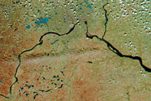
Acquired April 6, 2011, March 28, 2011, and February 28, 2011, these false-color images show the retreat of snow and advance of water in Minnesota and Wisconsin.
Published Apr 8, 2011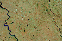
Acquired April 4, 2011, and March 5, 2011, these false-color images show snow cover retreat and rising rivers in South Dakota.
Published Apr 5, 2011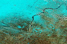
Acquired March 27, 2011, and February 28, 2011, these false-color images show rising waters on the Minnesota and Mississippi Rivers.
Published Mar 29, 2011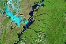
Acquired March 1 and 20, 2011, these false-color images show rising waters on the Mississippi River and some of its tributaries.
Published Mar 21, 2011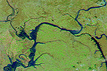
Acquired March 12, 2011, and February 12, 2011, these false-color images show parts of the Ohio and Mississippi Rivers before and after melting snow raised water levels.
Published Mar 14, 2011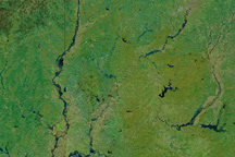
Swollen rivers and greening land in this image of southern Indiana on March 1, 2011, are signs that spring is approaching.
Published Mar 3, 2011