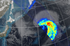

In 1997, NASA and the Japan Aerospace Exploration Agency (JAXA), launched the Tropical Rainfall Measuring Mission (TRMM) to learn more about the role of tropical rainfall in Earth’s water and energy cycles. Orbiting from 35° North to 35° South, the satellite carries the first space-based precipitation radar and a microwave imager designed to observe moderate to intense tropical rainfall.
Scientists wanted observations to improve their understanding of atmospheric circulation, one of Earth’s most important mechanisms for distributing energy from the sun-drenched tropics to Earth’s poles. Rainfall and evaporation play an important role in moving heat through the atmosphere. Evaporating water transfers energy to the atmosphere, which it releases as latent heat when water vapor condenses into cloud droplets and precipitation. This heat helps fuel winds and storms that move across the planet. Most of the latent heat in the atmosphere comes from tropical rainfall, but when TRMM launched, there were still huge uncertainties about how much tropical rain actually falls.
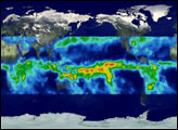
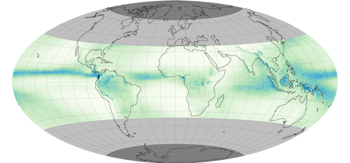
The map above shows one of the satellite’s key measurements: the average rate of rainfall per day (shown the years 1998 to 2011). A band of heavy rain, called the Intertropical Convergence Zone, wraps around the planet near the equator.
After 16 years, TRMM continues to provide important insights into tropical rainfall. But to fully understand the role of rainfall in the global water cycle, scientists need a planetary view—a view provided by the new Global Precipitation Mission (GPM) satellite. Launched on February 27, 2014, GPM flies in an orbit that takes it from 65° North to 65° South—an area including the TRMM data plus the lightly shaded gray area on the map above. This orbit allows the GPM to measure precipitation, including both rain and snow, everywhere except for the dark gray areas over the poles. The view expands measurements of precipitation to include population centers in the Northern Hemisphere, meaning GPM can be used to study extreme events in these locations. Scientists also will get a global view of precipitation, including the polar regions, by using GPM to calibrate observations from other satellites.
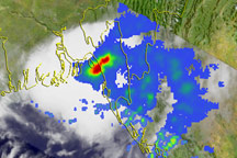
GPM also expands on the type of precipitation measurements. Like TRMM, the GPM satellite carries a precipitation radar, the Dual-frequency Precipitation Radar, and a microwave radiometer, the GPM Microwave Imager. While TRMM’s suite of instruments are optimized to measure moderate and heavy rain, they miss lighter rain and snow, two important components of the water cycle. The GPM instruments will measure all types of precipitation, observations that will help scientists better understand variability in the water cycle and the availability of fresh water; improve both weather and climate models; and improve hydrological models that help predict disasters like floods, droughts, hurricanes, and landslides.
GPM is now in its 60-day check-out period, when mission operators test the health of the satellite and its instruments. On March 4, the satellite’s microwave radiometer started collecting data on rain and snowfall. Measurements made since then indicate that the instrument and satellite platform are working well. Ongoing mission updates are available on the GPM web site.
NASA Earth Observatory image by Jessel Allen, using TRMM Composite Climatology data courtesy of Robert Atlas and Jian-Jian Wang (University of Maryland). Caption by Holli Riebeek.