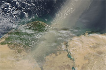
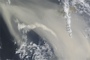
Dwarfing the Nile, a river of dust flowed out of the deserts of northern Egypt on May 19, 2007. As the Moderate Resolution Imaging Spectroradiometer (MODIS) on NASA’s Terra satellite passed overhead at 12:05 p.m. local time in Cairo, the sensor captured this image of the dust spreading northward over the Mediterranean Sea from the sandy deserts that span the country. At the margins of the plume, ribbons and ripples of dust are translucent, allowing a glimpse of the desert and water beneath, but in the center, the cloud is opaque, revealing nothing of the surface below.
The part of north-central Egypt hidden by the dust plume is the Qattara Depression, the country’s lowest point. Dipping down to 133 meters below sea level (436 feet), the depression is home to sandy deserts and dry lake beds that occasionally flood. The sand and fine, lake bed sediments are easily lofted into the air by strong winds that scour the area in late winter and early spring.
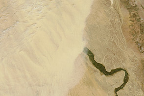
In the eastern (right-hand) part of the image, the Nile River is lined by narrow ribbons of dull green vegetation. The fan-shaped delta is dotted with tan-colored spots, marking the location of cities and towns. The Nile Valley and Delta make up only a small fraction of the country’s total land area, yet they support almost the entire population.
The large image provided above has a spatial resolution (level of detail) of 250 meters per pixel. The MODIS Rapid Response Team provides this image in additional resolutions. The Earth Observatory also provides a 250-meter-resolution KMZ file of this image for use with Google Earth.
NASA image by Jeff Schmaltz, MODIS Rapid Response Team, Goddard Space Flight Center.