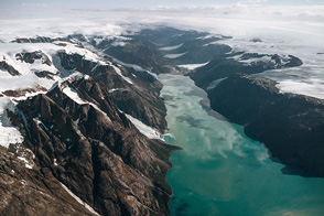
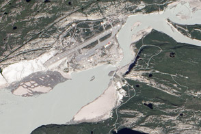
Naming an island that’s 90 percent ice-covered “Greenland” may seem ironic, but the Norse settlers who arrived in AD 985 found a few pockets of vegetation amid the barren rock and snow. Most of these settlements were near the southern tip of Greenland, sheltered deep within narrow fjords. The settlement of Brattahlid was one of Greenland’s wealthiest, founded by Erik the Red himself. Today the town of Qassiarsuk occupies the site of Brattahlid. In this image, Qassiarsuk’s bright green pastures stand out against the tan of bare rocks surrounding the blue water of Eiriksfjord. White icebergs float in the fjord, and snow remains near the surrounding hilltops, even in August.
The Norse inhabited Greenland for almost 500 years (longer than English-speaking colonists have survived in North America), subsisting primarily on sheep and goat milk, caribou, and seal. Curiously, the Greenland Norse do not seem to have eaten fish. The Norse devoted agricultural production to hay to feed livestock during the long winters. The total population of the scattered settlements was about 5,000 people.
A combination of factors, both natural and human-caused, extinguished the colony sometime in the fifteenth century. The largest natural cause was the cooling of Greenland in the 1400s. Cold weather would probably have reduced hay production and increased the amount of hay required for winter feed. Increased numbers of icebergs in the fjords and sea ice along the coast likely inhibited travel between settlements and mainland Europe (the last boat known to have returned to Europe from Greenland arrived in Norway in 1410).
Over time, the Norse Greenlandersdegraded their environment as well. Shortly after settlement, the settlers cut Greenland’s diminutive forests, limiting ship building, home construction, and iron production. Overgrazing and the use of turf for construction reduced pasture areas. Removal of turf exposed fragile topsoil to rapid erosion, preventing the re-growth of grass.
This image was acquired by the Enhanced Thematic Mapper plus aboard the Landsat 7 satellite on August 4, 2000.
NASA image by Robert Simmon, based on Landsat data provided by the Landsat 7 science team and the UMD Global Land Cover Facility