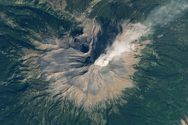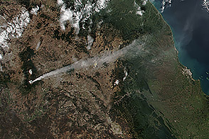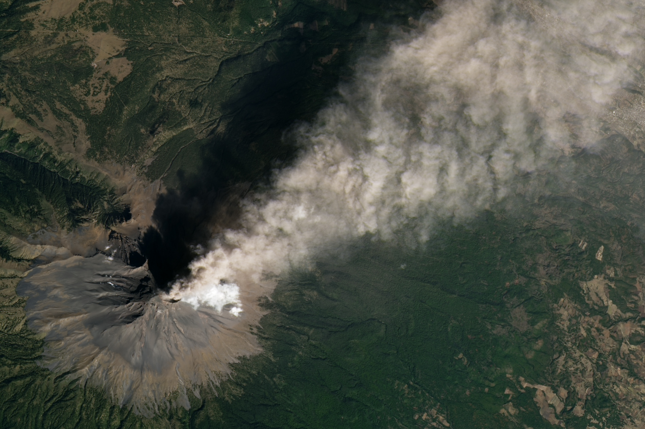
Popocatépetl, Mexico’s most active volcano and second-highest peak, sits just 70 kilometers southeast of Mexico City and 40 kilometers west of Puebla. The towering stratovolcano has been erupting for decades, with near constant venting from the crater punctuated by the cyclical growth of viscous lava domes and explosive blasts of ash and volcanic bombs.
The OLI (Operational Land Imager) on Landsat 8 captured an image of one of the volcano’s recent bouts of activity on January 27, 2024. According to Sébastien Valade, a volcanologist at National Autonomous University of Mexico, the brown part of the plume contains ash. In winter, winds often blow the ash to the east, as this image shows. In summer, the wind direction switches and often blows ash to the west and north.
“The ash is thin and not very high in the atmosphere, but there’s still enough of it to have minor impacts on nearby communities,” said Valade, who has developed a platform called MOUNTS (Monitoring Unrest From Space) that tracks Popocatépetl’s activity using data from several satellites. “Compared to what Popocatépetl is capable of, you can think of this as a little hiccup.”
Mexico’s Centro Nacional de Prevención de Desastres (CENAPRED) reported that the ash plume reached heights of roughly 2.4 kilometers (1.5 miles) on January 27 and led to minor ashfall in the towns of Nativitas, San Pablo del Monte, Ixtacuixtla de Mariano Matamoros, Zacatelco, Chiautempan, Santa Ana Nopalucan, Tlaxcala, Totolac, and Panotla. When volcanic ash—made of shards of glass and pulverized rock—falls on nearby communities, it can cause respiratory problems, contaminate drinking water, and harm livestock and crops.
The Washington Volcanic Ash Advisory Center, a NOAA group that tracks ash hazards, issued several alerts to pilots that day. Ash poses a risk to aircraft by blocking engine fuel nozzles, clogging air filters, and causing a range of other problems. According to one recent study of ash dispersal based on two decades of satellite observations from NASA’s MODIS (Moderate Resolution Imaging Spectroradiometer) sensor, there are more than 100 airways that can be affected by ash from eruptions at Popocatépetl.
The current level of activity at Popocatépetl regularly produce explosive eruptions that rank as about 2 or lower on the Volcano Explosivity Index (VEI), according to Smithsonian’s Global Volcanism Program. The highest value on the logarithmic scale is 8—an eruption so powerful that it would eject more than 1,000 cubic kilometers of material to heights of 25 kilometers or above, akin to the massive supervolcano eruptions that have occurred at Yellowstone in the United States or at Mount Toba in Indonesia.
Geologic evidence indicates that Popocatépetl, named for the Aztec word meaning “smoking mountain,” has produced at least four extremely explosive “Plinian” eruptions that ranked 3 or higher on the VEI index since the mid-Holocene, with the most recent in roughly 40 B.C.E. It has produced 37 known eruptions with a VEI of 1 or higher.
The most recent eruptive period began in 1994 after a 70-year period of quiet. “We saw about a decade of intensifying unrest that reached a crescendo of activity in the early 2000s,” Valade said. During the past decade, the intensity of the unrest had been gradually fading. “By early 2022, it looked like the eruption was on track to die out completely,” said Valade.
Then, in mid 2022, NASA’s OMI (Ozone Monitoring Instrument) sensor and the European TROPOMI (Tropospheric Monitoring Instrument) sensor began to detect increasing levels of sulfur dioxide emissions—a sign that fresh magma was entering and refilling Popocatépetl’s magma system and nearing the surface. This proved to be the first stage of another period of activity that peaked with a particularly explosive round of eruptions in May 2023.
Since then, the intensity of activity has been slowly fading, said Valade. He added: “But I expect we’ll continue to see sustained activity in the coming months and years because of that recharge period in 2022.”
NASA Earth Observatory image by Michala Garrison, using Landsat data from the U.S. Geological Survey. Story by Adam Voiland.