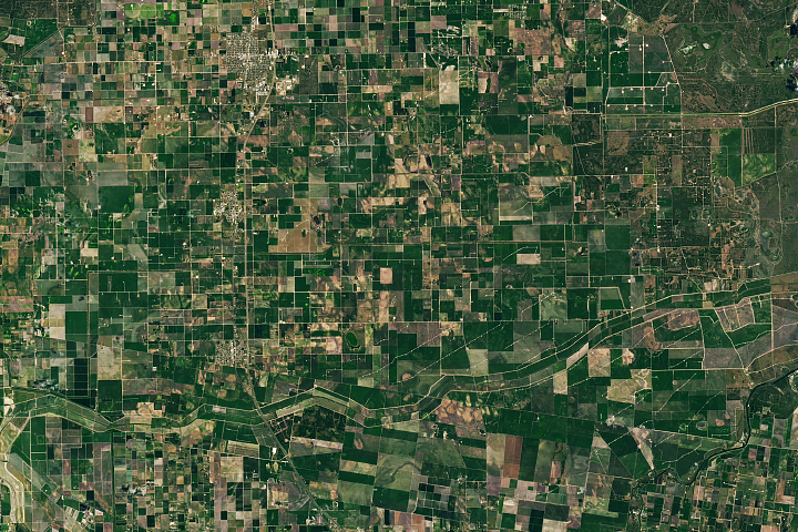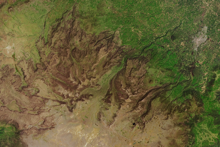
An astronaut aboard the International Space Station captured this photograph of the eastern portion of Edwards Plateau in central Texas. The cities of San Antonio and Austin line the ecological border of the plateau and the Blackland Prairies. This region of Texas is locally known as the “Texas Hill Country” and is a popular tourist destination within the state.
The eastern portion of the plateau consists of low, rolling hills while the western portion of the plateau (west of this image) reaches elevations up to 3,000 feet (915 meters). Tectonic uplift along geological faults millions of years ago formed the plateau. The plateau’s rocks host the Edwards Aquifer, a highly permeable limestone aquifer that provides water to surrounding counties. It also supplies water to the area’s artesian wells and natural springs, such as Barton Springs and Comal Springs. Numerous caves and caverns, such as the Natural Bridge Caverns, are found at the edge of the plateau in the Balcones Escarpment.
Amid the natural areas in this part of central Texas, there are ranches, farmlands, and urban areas. The urban areas, such as San Antonio and Austin, are lighter in color with networks of linear roadways. Agricultural use of the Blackland Prairies presents a patchwork pattern of exposed darker soils. Forests, conservation areas, and strings of cities fringe the Balcones Escarpment.
The plateau is one of the most biologically diverse areas in the United States with an extensive range of mammals, birds, reptiles, amphibians, and plants. This region’s rich biodiversity includes native endangered species, such as the Texas blind salamander, Texas wild-rice, and the golden-cheeked warbler.
Astronaut photograph ISS068-E-33243 was acquired on December 26, 2022, with a Nikon D5 digital camera using a focal length of 58 millimeters. It is provided by the ISS Crew Earth Observations Facility and the Earth Science and Remote Sensing Unit, Johnson Space Center. The image was taken by a member of the Expedition 68 crew. The image has been cropped and enhanced to improve contrast, and lens artifacts have been removed. The International Space Station Program supports the laboratory as part of the ISS National Lab to help astronauts take pictures of Earth that will be of the greatest value to scientists and the public, and to make those images freely available on the Internet. Additional images taken by astronauts and cosmonauts can be viewed at the NASA/JSC Gateway to Astronaut Photography of Earth. Caption by Sara Schmidt, GeoControl Systems, JETS Contract at NASA-JSC.