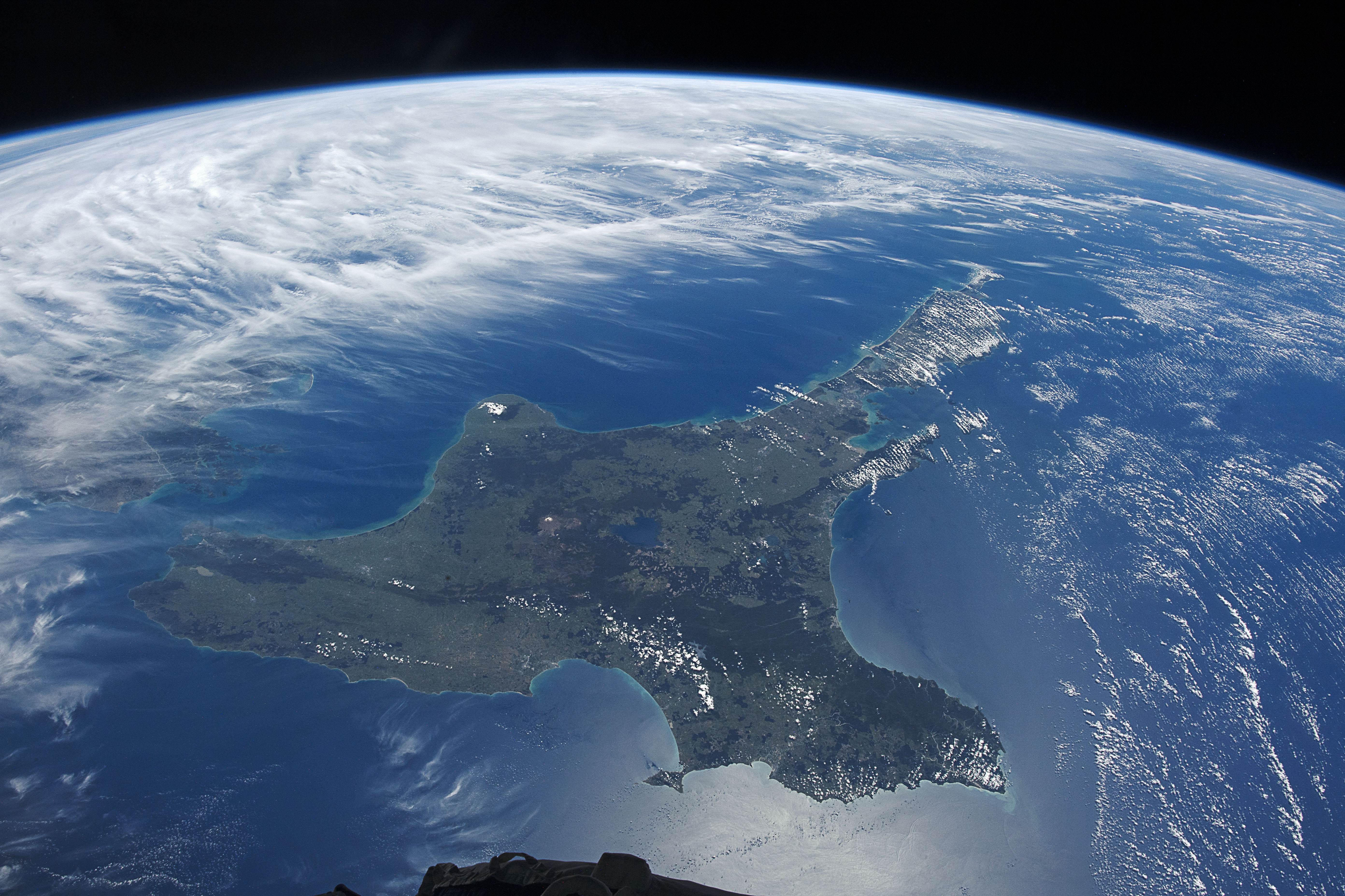
When the International Space Station (ISS) is near the southernmost extent of its prograde 51.6 degree orbit and weather conditions are right, astronauts can get a clear view of the North Island of New Zealand. Looking towards the northwest, the astronaut photographer captured the mottled-green island that separates the Tasman Sea from the South Pacific Ocean. On the other side of Cook Strait, South Island peeks out from beneath the cloud cover.
Seven bays surround the North Island and define its distinctive shape. The inland landscape includes grasslands (lighter green areas), forests (darker green areas), volcanic plateaus, and mountain ranges formed from sedimentary rocks.
In the center of the island, Lake Taupō—a crater lake inside a caldera formed by a supervolcanic eruption—borders the island’s highest peak—the active volcano Mount Ruapehu. The volcanic nature of the island arises from its location on the tectonic plate boundary between the Indo-Australian and Pacific Plates. This plate boundary is part of the vast Pacific Ring of Fire, and leads to significant geothermal activity and earthquakes in the region. Additional volcanoes, including Mount Taranaki (Egmont Volcano), also dot the North Island landscape.
Two main population centers—the capital city of Wellington and the country’s largest city, Auckland—lie on opposite ends of the island. These and other urban areas occupy about 1 percent of New Zealand’s land area but hold about 87 percent of the country’s population.
Astronaut photograph ISS066-E-115830 was acquired on January 2, 2022, with a Nikon D5 digital camera using a focal length of 24 millimeters. It is provided by the ISS Crew Earth Observations Facility and the Earth Science and Remote Sensing Unit, Johnson Space Center. The image was taken by a member of the Expedition 66 crew. The image has been cropped and enhanced to improve contrast, and lens artifacts have been removed. The International Space Station Program supports the laboratory as part of the ISS National Lab to help astronauts take pictures of Earth that will be of the greatest value to scientists and the public, and to make those images freely available on the Internet. Additional images taken by astronauts and cosmonauts can be viewed at the NASA/JSC Gateway to Astronaut Photography of Earth. Caption by Alex Stoken, Jacobs, JETS Contract at NASA-JSC.