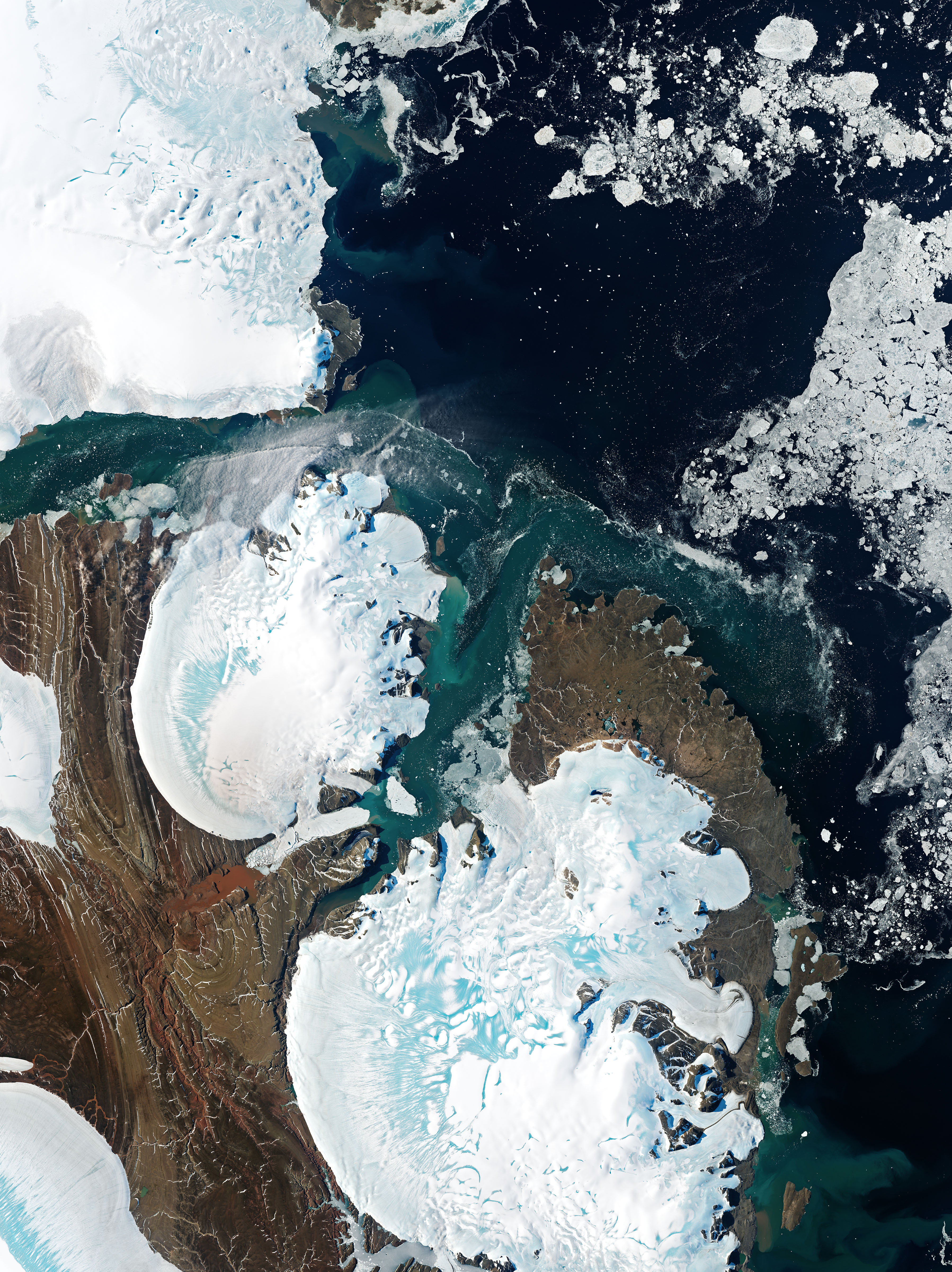
Across the Northern Hemisphere, more than 1,700 glaciers ultimately dip their icy snouts into the ocean. Many of these glacier fronts are floating, with some spreading out into wide, flat ice shelves. Others are grounded, connected to the seafloor below. Almost all of them are retreating.
That is the conclusion of recent research by William Kochtitzky and Luke Copland, glaciologists at the University of Ottawa. Using images from Landsat and Terra satellites, the researchers manually outlined the position of each glacier’s front in 2000, 2010, and 2020. They found that 85 percent of the glaciers had retreated during these two decades, accounting for a total loss of about 7,500 square kilometers (2,900 square miles) of ice.
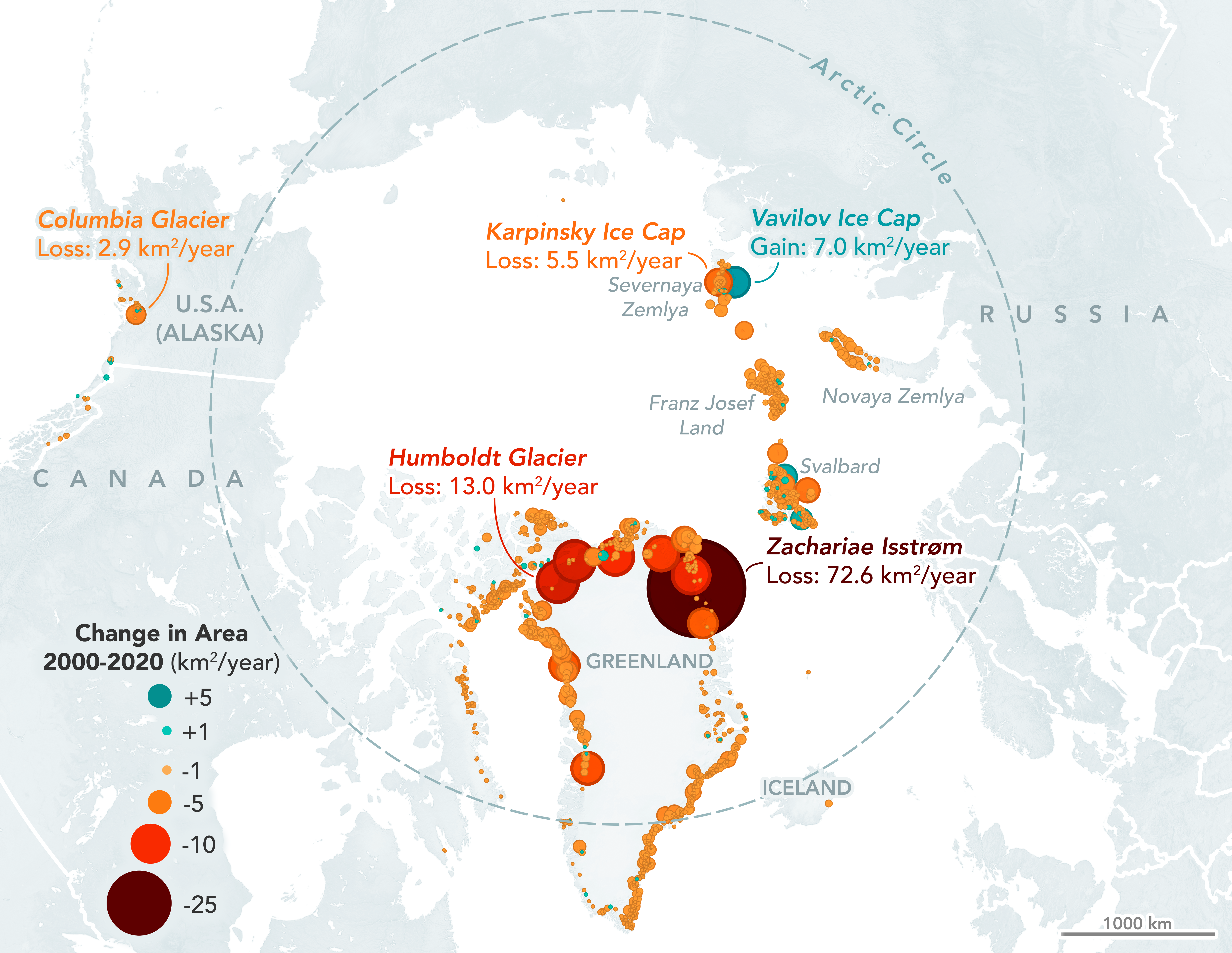
The map above shows where those changes occurred. Areas marked with large red dots lost the most ice, and large blue dots gained the most. Most of the losses (62 percent) come from outlet glaciers along the periphery of Greenland’s enormous ice sheet. Notice the especially large red dot in northeast Greenland. This is Zachariae Isstrøm, which lost 1,453 square kilometers (561 square miles) of ice between 2000-2020.
“The changes at Zachariae Isstrøm in Greenland are incredible,” Kochtitzky said. “It lost 73 square kilometers per year. That is nearly six times more than the glacier with the second-most area loss.”
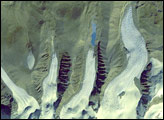
Marine-terminating glaciers and ice shelves outside of Greenland also are losing ice. For example, the collapse of the Matusevich Ice Shelf in the Russian Arctic was the biggest contributor to losses in the Northern Hemisphere outside of Greenland.
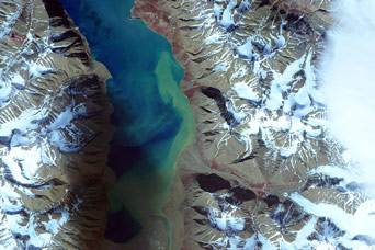
The ice shelf previously floated in Matusevich Fjord, visible in this image acquired on August 3, 2021, with the Operational Land Imager (OLI) on Landsat 8. The fjord is located on the northeastern side of October Revolution Island in the Severnaya Zemlya Archipelago. Its waters connect to the Laptev Sea.
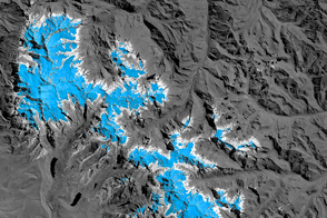
The outlines show the extent of the ice shelf in 2000 (yellow), 2010 (orange), and 2020 (red), as determined from Landsat images. In 2000, six glaciers flowed from the Rusanov and Karpinsky ice caps, and their glacial ice spread across the fjord. Between 2010 and 2020 the shelf collapsed, expelling ice toward the north, and and isolating the individual glacier fronts. The ice shelf and glaciers lost nearly 160 square kilometers (62 square miles) of ice between 2000-2020.
The Matusevich Ice Shelf has collapsed before. Previous research describes it breaking apart in the mid-1980s, after which it re-formed, then broke up again in 2012. The periodic collapses have been known to calve tabular icebergs measuring a few kilometers long. A collapse can be triggered by warm air and ocean temperatures, which melt a shelf from above and below, causing it to thin and weaken. In periods when there is less sea ice adjacent to the shelf, the glacial ice becomes exposed and vulnerable to ocean waves.
Each marine-terminating glacier in the world advances and retreats under unique circumstances, depending on factors like contact with the seafloor or the shape of the fjord. Still, the study shows a clear pattern across the Northern Hemisphere. “In all, 123 glaciers that ended in the ocean in 2000 now end on land,” Kochtitzky said.
The updated inventory of glacier positions is especially useful for modeling studies. “We previously didn’t know the volume of ice lost to the ocean every year as icebergs, which we call frontal ablation,” Kochtitzky said. “At the moment, we are using these data to calculate frontal ablation for additional projects, some of which help project future glacier changes through the end of the century to constrain sea level rise.”
NASA Earth Observatory images by Joshua Stevens, using Landsat data from the U.S. Geological Survey, and data courtesy of Kochtitzky, W., & Copland, L. (2022). Story by Kathryn Hansen.