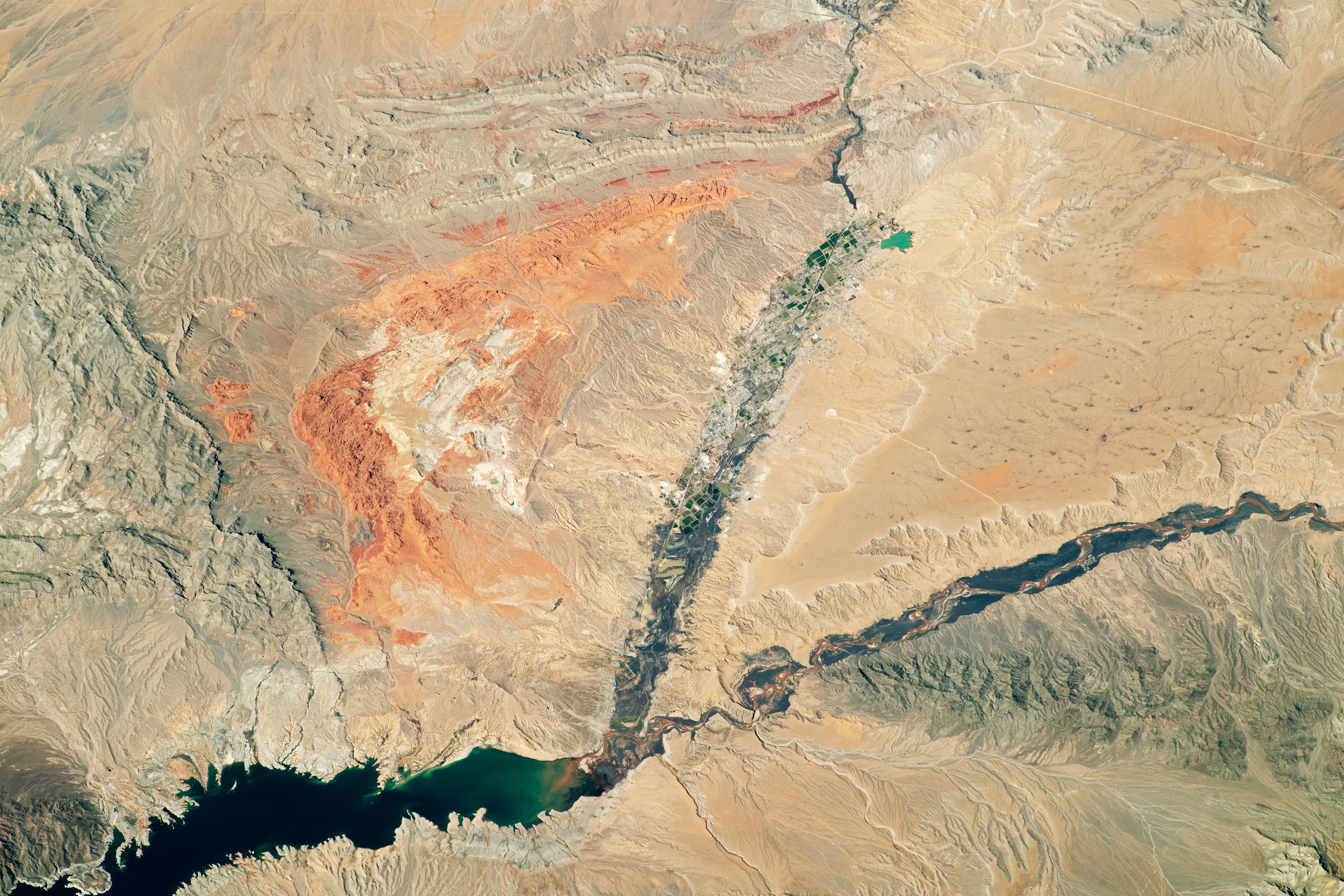
While in orbit over southern Nevada, an astronaut onboard the International Space Station took this photo of brightly colored rocks and deep canyons in the Mojave Desert.
The Muddy and Virgin Rivers cut through the desert to deliver water to Lake Mead reservoir. The Muddy River flows through Moapa Valley, where it is bordered by agricultural fields and towns. The nearby Virgin River, by contrast, is bordered by dark vegetated areas and lacks urban structures. Both rivers empty into the Overton Arm, the northern part of Lake Mead that eventually merges with the Colorado River to the south.
Red-orange rock exposures near the center of the photo mark the Valley of Fire State Park, located approximately 40 miles (60 kilometers) to the northeast of Las Vegas. At sunset, valley outcrops made of bright, rust-colored Aztec sandstone appear to be on fire, which led early European explorers to give the area its colorful name. This sandstone here formed from ancient sand dune fields that covered the area during the Jurassic Period. The slab was subsequently faulted and uplifted by tectonic forces, and then eroded by water and wind into the current landscape.
Significant archaeological artifacts have been found throughout Moapa Valley, with some dating back to 300 BCE. Among the finds are ancient petroglyphs (not visible in this photo) etched into the sandstone. Anasazi Native Americans occupied the area during that time, hunting, gathering, and building pueblo villages. The discovery of pit houses, pueblo walls, and other ancient cultural artifacts in what was to become Lake Mead caused people to dub the area “the Lost City.” At the top of this photograph, the southern part of the Moapa River Indian Reservation is visible.
Astronaut photograph ISS062-E-55262 was acquired on February 25, 2020, with a Nikon D5 digital camera using a focal length of 400 millimeters. It is provided by the ISS Crew Earth Observations Facility and the Earth Science and Remote Sensing Unit, Johnson Space Center. The image was taken by a member of the Expedition 62 crew. The image has been cropped and enhanced to improve contrast, and lens artifacts have been removed. The International Space Station Program supports the laboratory as part of the ISS National Lab to help astronauts take pictures of Earth that will be of the greatest value to scientists and the public, and to make those images freely available on the Internet. Additional images taken by astronauts and cosmonauts can be viewed at the NASA/JSC Gateway to Astronaut Photography of Earth. Caption by Sara Schmidt, GeoControl Systems, JETS Contract at NASA-JSC.