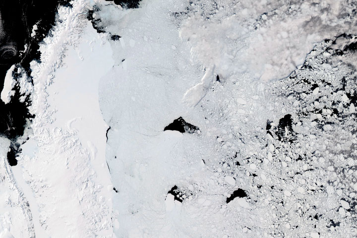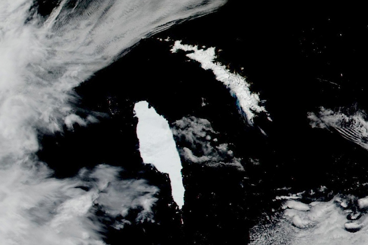
Iceberg A-68A made headlines in July 2017 when the Delaware-sized block of ice broke from the Larsen C Ice Shelf on the Antarctic Peninsula. The berg has regained the spotlight in austral spring 2020, as it is now drifting toward South Georgia, a remote island in the southern Atlantic Ocean.
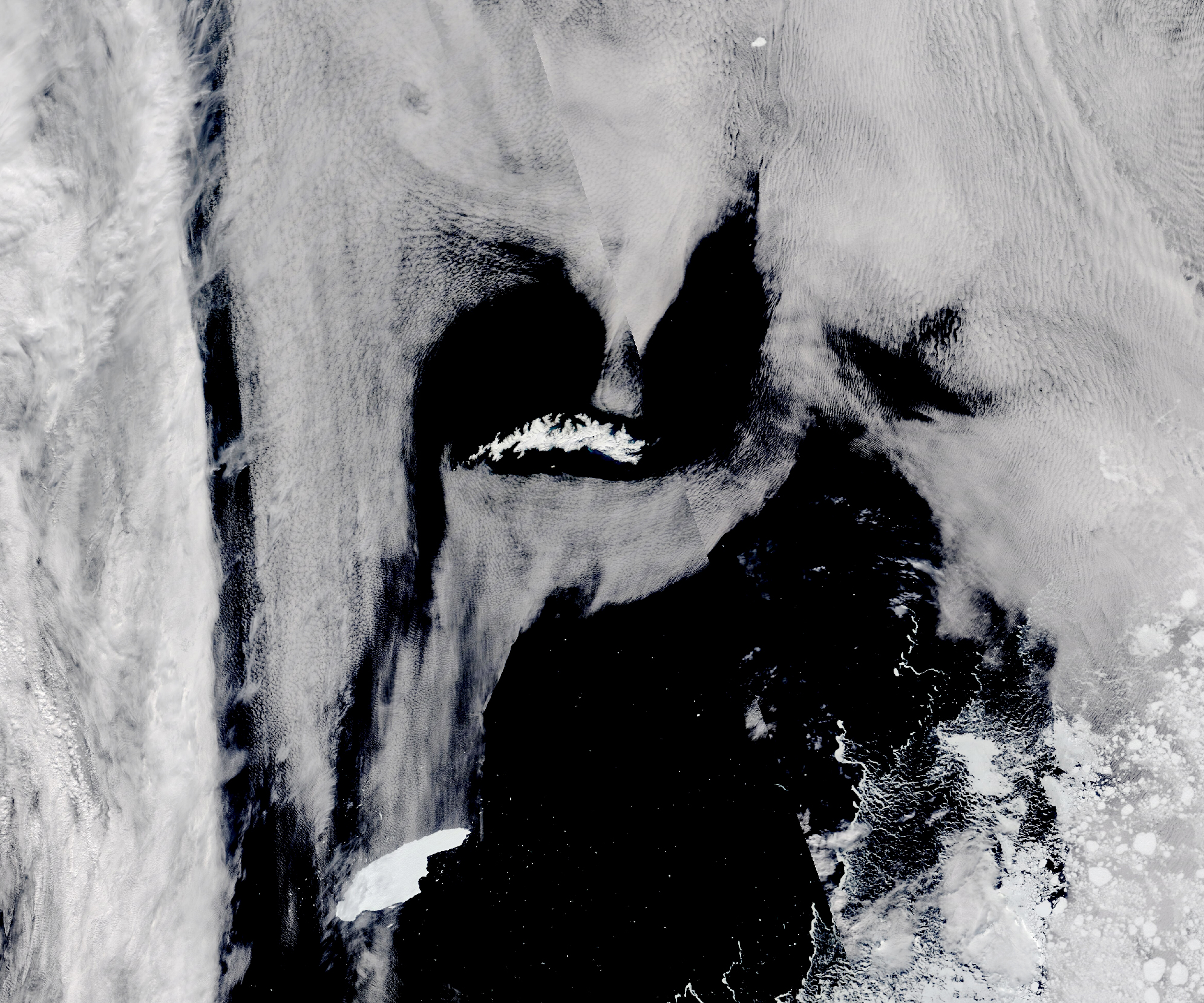
The iceberg and island are both visible in this image, acquired on November 5, 2020, with the Moderate Resolution Imaging Spectroradiometer (MODIS) on NASA’s Terra satellite. The berg now measures 151 kilometers (94 miles) long and 48 kilometers (30 miles) wide—comparable to the island’s length and width of 167 and 37 kilometers (104 and 23 miles), respectively. It is less than 500 kilometers (300 miles) from the island’s southwest shore.
In just over three years at sea, Iceberg A-68A has moved generally northward, passing the tip of the Antarctic Peninsula and floating into “Iceberg Alley.” According to David Long, a remote sensing and polar ice scientist at Brigham Young University, more than 90 percent of all Antarctic icebergs are swept along this path from the Weddell Sea toward the South Atlantic Ocean.
“Most just don’t survive the journey from the Weddell to South Georgia,” Long said. So far, A-68A’s huge size has helped it survive the relatively warm, iceberg-killing waters of the South Atlantic that can cut like knives through lesser bergs.
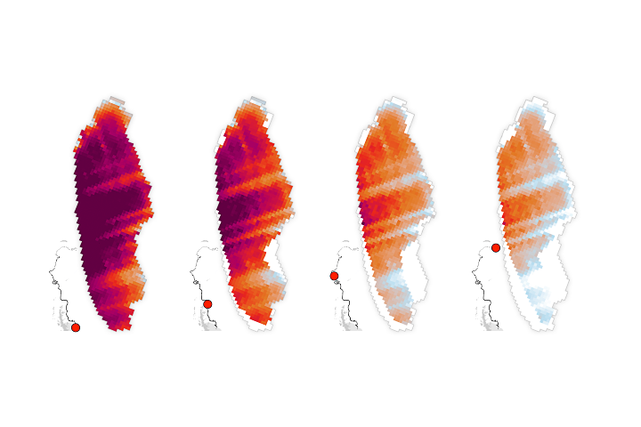
The map below shows the path of A-68A, based on data from the Antarctic Iceberg Tracking Database. Long and colleagues created the database in 1999 after tracking a similarly large berg (B-10A).
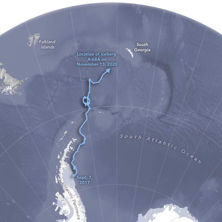
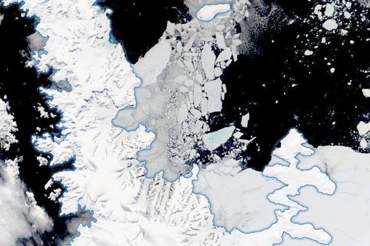
While A-68A is following a similar path of many icebergs before it, the details of its journey are unique. In April 2020, A-68A was already adrift in relatively warm waters near the South Orkney Islands, about 800 kilometers (500 miles) from where it broke from the Antarctic ice shelf in 2017. Over the course of the austral winter, sea ice grew to mostly surround A-68A, according to Christopher Readinger of the U.S. National Ice Center (USNIC). Then, currents and wind carried the iceberg out of the sea ice. For several months the berg meandered north, spinning and revolving around oceanic eddies, until it was recently kicked to the northeast toward South Georgia.
News reports have pointed to a possible collision with the island, or that the iceberg could become stuck, or “grounded,” in the shallow waters surrounding it. Either outcome could mean trouble for the island’s abundant wildlife if the berg blocks the foraging routes of penguins and seals.
“The currents and eddies are probably too chaotic to really make a prediction about where it will go and how fast it will get there besides some average component of north-east over the next few months,” Readinger said. “The recent news about it seems to be expecting that it will ground at South Georgia. I’m not so sure.”
Long agrees, noting that historical precedent suggests the iceberg is likely to pass just south of South Georgia. “If it is close enough to the island, it could get caught in the vortex in ocean currents to the east of the island and be pulled back toward the island by counter currents, much as A-22A did more than a decade ago,” Long said. “If, however, it passes far enough to the south, it will miss the counter current the vortex and probably keep heading east-northeast.”
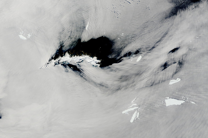
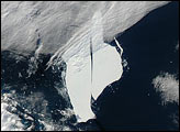
Whether it becomes stuck or sails smoothly on by, Iceberg A-68A will eventually move past South Georgia. That’s when Readinger thinks the iceberg is likely to break up into smaller bergs, a few of which should be sizable enough to be named by the USNIC. For example, A-68C is located about 420 kilometers (260 miles) northeast of South Georgia in the image at the top of this page. That new berg, identified in April 2020, is already breaking up into smaller pieces and will soon be too small for USNIC scientists to track.
NASA Earth Observatory images by Lauren Dauphin, using MODIS data from NASA EOSDIS/LANCE and GIBS/Worldview, Reference Elevation Model of Antarctica (REMA) data from the Polar Geospatial Center at the University of Minnesota and data from the Antarctic Iceberg Tracking Database. Story by Kathryn Hansen, with image interpretation from David Long/BYU, Christopher Readinger/USNIC, and Christopher Shuman (NASA/UMBC).