This map of topography and water depth along the Chilean coast includes black circles that indicate aftershocks with a magnitude of 5.0 or larger that occurred between March 5 and 12, 2010, following the large earthquake on February 27.
Published Mar 11, 2010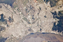
Smoke plumes and apparent damage to a bridge are visible in this astronaut photograph of Concepción, Chile, following the magnitude 8.8 earthquake on February 27, 2010.
Published Mar 4, 2010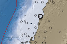
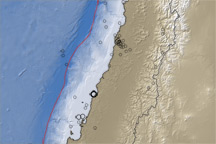
This map of topography and water depth reveals subduction’s influence on the West Coast of South America near the epicenter of the 8.8-magnitude earthquake that struck Chile on February 27, 2010.
Published Mar 2, 2010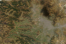
Black smoke lingered over the metropolitan area of Santiago, Chile, following a magnitude 8.8 earthquake on February 27, 2010.
Published Feb 27, 2010