
This pair of images from August 22 shows a natural-color (photo-like) view of Hurricane Bill captured by the Moderate Resolution Imaging Spectroradiometer (MODIS) on NASA’s Aqua satellite combined with a view of the vertical structure of the clouds measured by the radar on the Cloudsat satellite.
Published Aug 24, 2009
Acquired August 23, 2009, this true-color image shows Hurricane Bill missing the U.S., apparently headed northward toward Canada.
Published Aug 23, 2009
Hurricane Bill's spiraling clouds sprawl across hundreds of kilometers northeast of Puerto Rico in this image from August 20, 2009.
Published Aug 20, 2009
Hurricane Bill was a large Category 4 storm when this image was captured on August 19, 2009.
Published Aug 19, 2009
The first full-disk thermal image from the newest NASA/NOAA weather satellite shows the remnants of Tropical Storm Claudette and Tropical Depression Ana, as well as Hurricane Bill on August 17, 2009.
Published Aug 19, 2009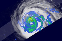
Hurricane Bill had a well-formed eye surrounded by concentric bands of rain late on August 17.
Published Aug 18, 2009
With a well-formed eye and a symmetrical shape, Hurricane Bill looked the part of the major hurricane it was forecast to become when this photo-like image was taken on August 18, 2009.
Published Aug 18, 2009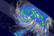
TRMM reveals that although Bill did not yet have an eye or eyewall, it did have a well-developed cyclonic circulation as evidenced by the curvature in the rain bands that spiral in towards the center.
Published Aug 17, 2009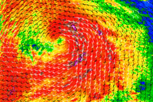
Strong winds and heavy rain are revealed near the eye of Hurricane Bill in this QuikSCAT satellite image from August 16, 2009.
Published Aug 17, 2009