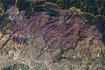
This natural-color image from the Advanced Land Imager on NASA’s Earth Observing-1 (EO-1) satellite shows the Jesusita Fire burned area on May 13, 2008.
Published May 15, 2009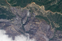
This natural-color image from May 10, 2009, shows the northern part of the area burned by the Jesusita Fire, in the Los Padres National Forest north of Santa Barbara, California.
Published May 12, 2009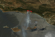
Acquired on May 8, 2009, this true-color image shows fire locations and smoke plumes from the Jesusita Fire near Santa Barbara, California.
Published May 8, 2009