Atmosphere
Heat
Human Presence
Land
Life
Natural Events
All
Drought
Dust and Haze
Earthquakes
Fires
Floods
Landslides
Man-made
Sea and Lake Ice
Severe Storms
Temperature Extremes
Unique Imagery
Volcanoes
Water Color
Remote Sensing
Snow & Ice
Water
Collections
ABCs from Space
Air Quality
Amazon Deforestation
Applied Sciences
Astronaut Photography
Backgrounders
Blue Marble
Earth at Night
Earth from Afar
Fall Colors
Food and Agriculture
International Parks and UNESCO Sites
Renewable and Alternative Energy
Sea Level Rise
U.S. National Parks
World of Change
EO Explorer
Topics
Search
Images
Global Maps
Articles
Blogs
EO Explorer
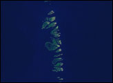
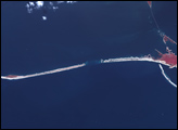
Hurricane Katrina Erodes the U.S. Gulf Coast
Hurricane Katrina's powerful storm surge, battering waves, and strong winds reshaped the barrier islands along the Gulf Coast of the United States.
Image
Chandeleur Islands
Published Oct 7, 2005
Image of the Day
Land
Unique Imagery
Image
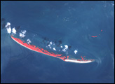
Hurricane Katrina Erodes the U.S. Gulf Coast
Published Sep 20, 2005
Unique Imagery
Image
Hurricane Katrina Erodes the U.S. Gulf Coast
Published Sep 20, 2005
Unique Imagery
Image
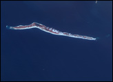
Gulf Islands National Seashore after Katrina
Published Sep 18, 2005
Image of the Day
Land
Water
Unique Imagery
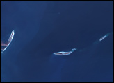
Image
Hurricane Katrina Erodes the U.S. Gulf Coast
Published Sep 15, 2005
Unique Imagery
Subscribe
To Our Newsletters
Receive notifications of our most recent images!
to our newsletters