
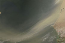
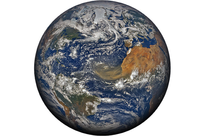
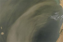
A well-defined plume of dust swept across the entire Atlantic Ocean on June 24, 2009. In this photo-like image taken by the Moderate Resolution Imaging Spectroradiometer (MODIS) on NASA’s Aqua satellite in three consecutive overpasses, the dust stretches from its origins in Africa’s Sahara Desert to the Lesser Antilles Islands on the eastern edge of the Caribbean Sea. Such spectacular dust storms are not uncommon.
Saharan dust often travels across the Atlantic thanks to a hot, dry, dusty layer of air known as the Saharan Air Layer. Extreme daytime heating of the Sahara creates instability in the lowest layer of the atmosphere, lofting dust particles into the air. The dust-laden air layer continues warming as it travels westward across the Sahara. As the Saharan Air Layer moves off the west coast of Africa, it passes over a cooler, wetter layer of air. This temperature inversion (air usually cools with altitude) prevents mixing, enabling the dust layer to travel across the ocean intact. Across the Atlantic, dust brings problems and benefits: respiratory illness and coral bleaching, but also rich soils.
A distinct boundary separates the plume of dust from the line of clouds to the south. These dense clusters of clouds hold moist, tropical air and are likely intense rainstorms. Fueled in part by the same winds that power the dust storm, these clouds may be signs of African easterly waves. The storms are gathered in three distinct clumps separately by gaps of clearer skies. African easterly waves are atmospheric disturbances that can develop into strong storms. They are the origins of some hurricanes. By contrast, the air in the Saharan Air Layer is dry. The contrast between the two air layers generates winds that help propel the dust across the Atlantic.
The difference between moist tropical air and the Saharan Air Layer is also evident in the cloud structures within the dust versus clouds to the south. The moist tropical clouds are large clusters. The clouds in the dust layer are small and hold the shape of the wind. The clouds in the upper right portion of the image are long and sweeping, echoing the shape of the dust plume, and the clouds behind the Cape Verde Islands swirl in the turbulence generated in the wake of the islands. These tiny clouds may have formed around the dust particles. They contain dry air and probably won’t produce rain.
The large image provided above has a resolution of one kilometer per pixel. A higher resolution image (500 meters per pixel) is available from the MODIS Rapid Response System.
NASA image by Jeff Schmaltz, MODIS Rapid Response. Caption by Michon Scott and Holli Riebeek with information provided by William Lau, NASA Goddard Space Flight Center.


