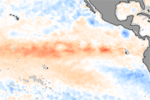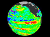
The equatorial Pacific trade winds typically blow from east to west, pushing the warm surface waters toward the west and allowing the cold, deep waters along the west coast of South America to upwell. But the trade winds in the western Pacific flip-flopped in June 2002, shutting down the westward flow of warm surface waters. Some of this warm water then began to flow back eastward, blocking the upward flow of cold, deep water in the east. When this sequence of events happens (roughly every 3 to 7 years), the intense tropical sun rapidly warms the surface of the eastern Pacific to above-average temperatures. Scientists refer to this warm Pacific temperature anomaly as El Niño, and already its effects are being felt around the world as the climate phenomenon returns.
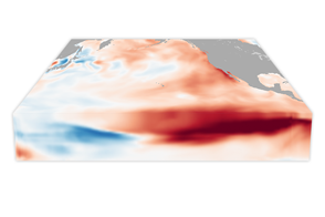
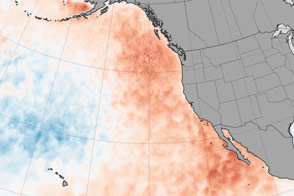
This false-color image represents sea surface temperature anomaly, or departure from normal values. Red pixels show where the ocean is warmer than average and blues show where the ocean is cooler than average. White shows little or no change in temperature in either direction. Grey pixels show where no data were obtained due to cloud cover. This image was produced by comparing recent sea surface temperature measurements collected from November 23-30, 2002, by the Moderate Resolution Imaging Spectroradiometer (MODIS), aboard NASA’s Terra satellite, with averaged climatology data collected over the last 15 years by NOAA’s Advanced Very High Resolution Radiometer (AVHRR). The difference between the MODIS measurements and the long-term average is considered a “temperature anomaly” and this false-color map is produced based upon the difference.
From past El Niño events, we know that as the warming moves progressively eastward in the Pacific, effects on weather in the United States become more pronounced. Normally, El Niño’s effects on U.S. weather are strongest from mid-winter into early spring. Because the waters in the western and central Pacific have been warmer than average for several months, Australia has experienced much drier than usual weather, which has contributed to the severe wildfire activity ongoing there in recent months. Luckily, South America was not too severely affected by the current El Niño because the warm water had not moved far enough east to affect their winter weather.
Image courtesy Jesse Allen, NASA’s Earth Observatory, based upon data provided by the MODIS Ocean Science Team, NASA GSFC, and AVHRR climatology data produced by Ken Casey.