The Earth Observatory has published its last Image of the Day on this website. Please join us on our new home at science.nasa.gov/earth/earth-observatory.

Editor’s Note: Today’s story is the answer to the September 2025 puzzler.
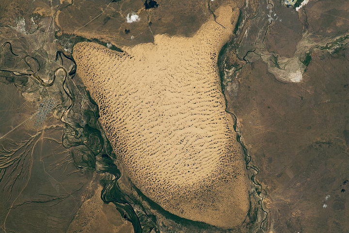
In the Tarim Basin in western China, a curved ridge and winding river converge in a Y-shaped tangle of sand, rock, and water channels. Even from space, it’s easy to see why the colorful ridge—Mazartagh—is known in Chinese as Hongbaishan, or “red-white mountain.”
The OLI-2 (Operational Land Imager-2) on Landsat 9 acquired this image on September 11, 2025, showing where the river meets the ridge. The wall-like ridge stretches 145 kilometers (90 miles) to the northwest and rises about 200 meters (600 feet) above the surrounding desert. It acts as a natural barrier, trapping sand and blocking dunes from moving southward under the basin’s frequent northeasterly winds. The image below shows a broader view of the same area.
The dark red rock formations on the northern side of Mazartagh are made of iron-rich sandstones and mudstones that were likely deposited in an arid, oxygen-rich environment, such as a desert dune field or an alluvial fan. In contrast, the lighter-colored formations in the southern part of the ridge are made up of layers of gypsum and calcareous sandstone that typically form in shallow water environments, such as lake beds.

The Hotan River (also called the Khotan River) is a seasonal feature fed by glacial meltwater from the Kunlun Mountains, which line the basin to the south. The river carries large summer flows northward across the Takla Makan Desert until it meets the Tarim River in the far northern part of the basin.
Of the many glacial meltwater streams that descend from the mountains, the Hotan is the only one that sustains a flow over such a long distance in the heart of one of the world’s driest deserts. The greens visible along the river’s channel are vegetated areas, where plants like poplars, salt cedars, and seasonal grasses can thrive despite swings in water availability and the presence of harsh saline soils.
Both features influence the surrounding dune fields. According to one team of researchers, Mazartagh blocks about 62 percent of the sand and reduces the north-to-south drift potential of dunes by 13 percent. As a result, sand seas pile up north of the ridge in fields of barchan, compound transverse dunes, and star dunes. South of the ridge, the reduced sand supply leads to the dominance of elongated linear and compound linear dunes. However, notches in the ridge allow enough sand to pass through for some barchan dune fields to form in that area as well.
The region’s remarkable landscape and geology have also played a role in human affairs. The Hotan River’s sediments carry significant quantities of both white and green nephrite, prized types of jade. People have long collected bits of the precious mineral by hand, gathering nephrite pebbles and boulders from the river’s gravel bars and banks after floods, helping turn this area into a key stop along the Silk Road.
Part of an ancient fort dating from the eighth century and the time of the Tibetan Empire still stands atop a hill overlooking the river. In 1907, a British archaeologist excavated the site, known as Mazar Tagh, yielding hundreds of military documents that helped reveal the region’s early history.
NASA Earth Observatory images by Lauren Dauphin, using Landsat data from the U.S. Geological Survey. Story by Adam Voiland.