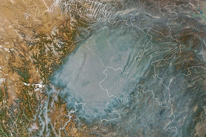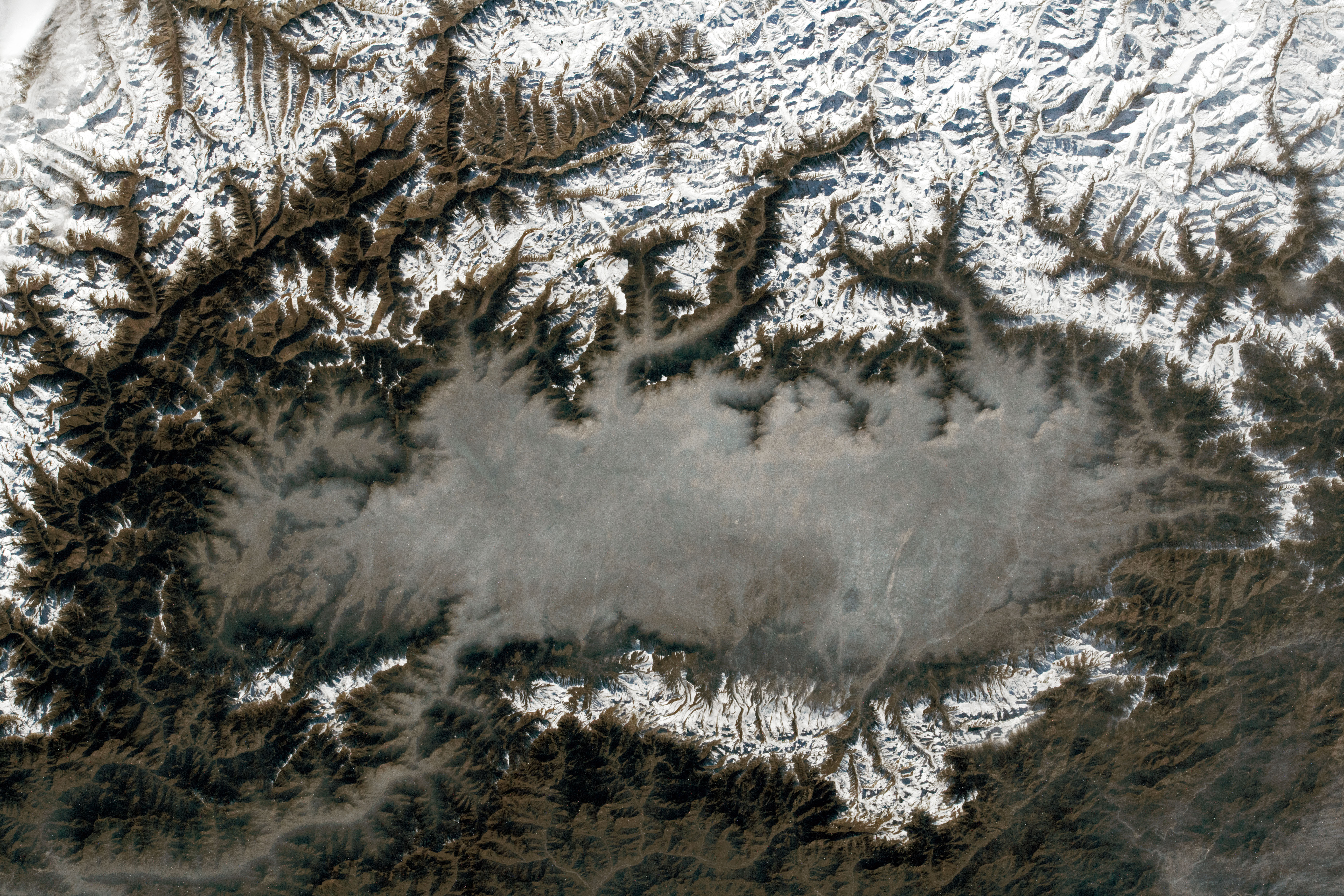
The Kashmir Valley, also called the Vale of Kashmir, is an ancient, dried lake basin surrounded by ranges of the Himalaya Mountains. An astronaut aboard the International Space Station took this photograph of the region while orbiting over South Asia.
Although the Kashmir Valley no longer holds water, rainwater and snowmelt from the surrounding mountains drain through the basin via several waterways, including the Sind and Jhelum Rivers.
Several noteworthy peaks are visible within the mountain ranges adjacent to the valley. Mount Kolahoi, located east of the valley, is the tallest mountain in Kashmir at 5,425 meters (17,799 feet) above sea level. (Note that the image has been rotated such that north is toward the top-left.) Kolahoi Glacier—one of the largest glaciers in the region—rests on its northern slope. Mount Harmukh (5,142 meters, or 15,870 feet), located northeast of the valley, is considered a sacred peak in Hinduism and is a popular destination for pilgrims.
Temperature inversions often occur in the Kashmir Valley when cold, dense air flows down from the surrounding Himalayas and becomes trapped under warmer, comparably less dense air. Inversions are more common in winter, when the days are shorter and snow on the valley floor helps keep the air in the lower atmosphere from warming and mixing with upper level air.
A byproduct of temperature inversions in Kashmir Valley is a buildup of haze—an aerosol mixture composed of fine particles found in smog, smoke, and dust. The trapped aerosols absorb and scatter incoming sunlight, creating a layer of poor visibility. Haze has also been observed in the Kashmir Valley over the previous years by satellite sensors.
The city of Srinagar is located underneath a region of haze near the center of the photograph. Srinagar is the largest municipality in the Kashmir Valley and a contributor of smog, smoke, and other human-caused aerosols.
Astronaut photograph ISS066-E-84674 was acquired on December 1, 2021, with a Nikon D5 digital camera using a focal length of 70 millimeters. It is provided by the ISS Crew Earth Observations Facility and the Earth Science and Remote Sensing Unit, Johnson Space Center. The image was taken by a member of the Expedition 66 crew. The image has been cropped and enhanced to improve contrast, and lens artifacts have been removed. The International Space Station Program supports the laboratory as part of the ISS National Lab to help astronauts take pictures of Earth that will be of the greatest value to scientists and the public, and to make those images freely available on the Internet. Additional images taken by astronauts and cosmonauts can be viewed at the NASA/JSC Gateway to Astronaut Photography of Earth. Caption by Cadan Cummings, Jacobs, JETS Contract at NASA-JSC.