There are many ways that living creatures shape, color, and transform the Earth. Phytoplankton can paint the ocean with color when they multiply in prodigious blooms. Insect infestations can deplete or destroy forest cover. Beavers build dams that flood wetlands and sometimes create small lakes. And humans leave their fingerprints all over the planet.
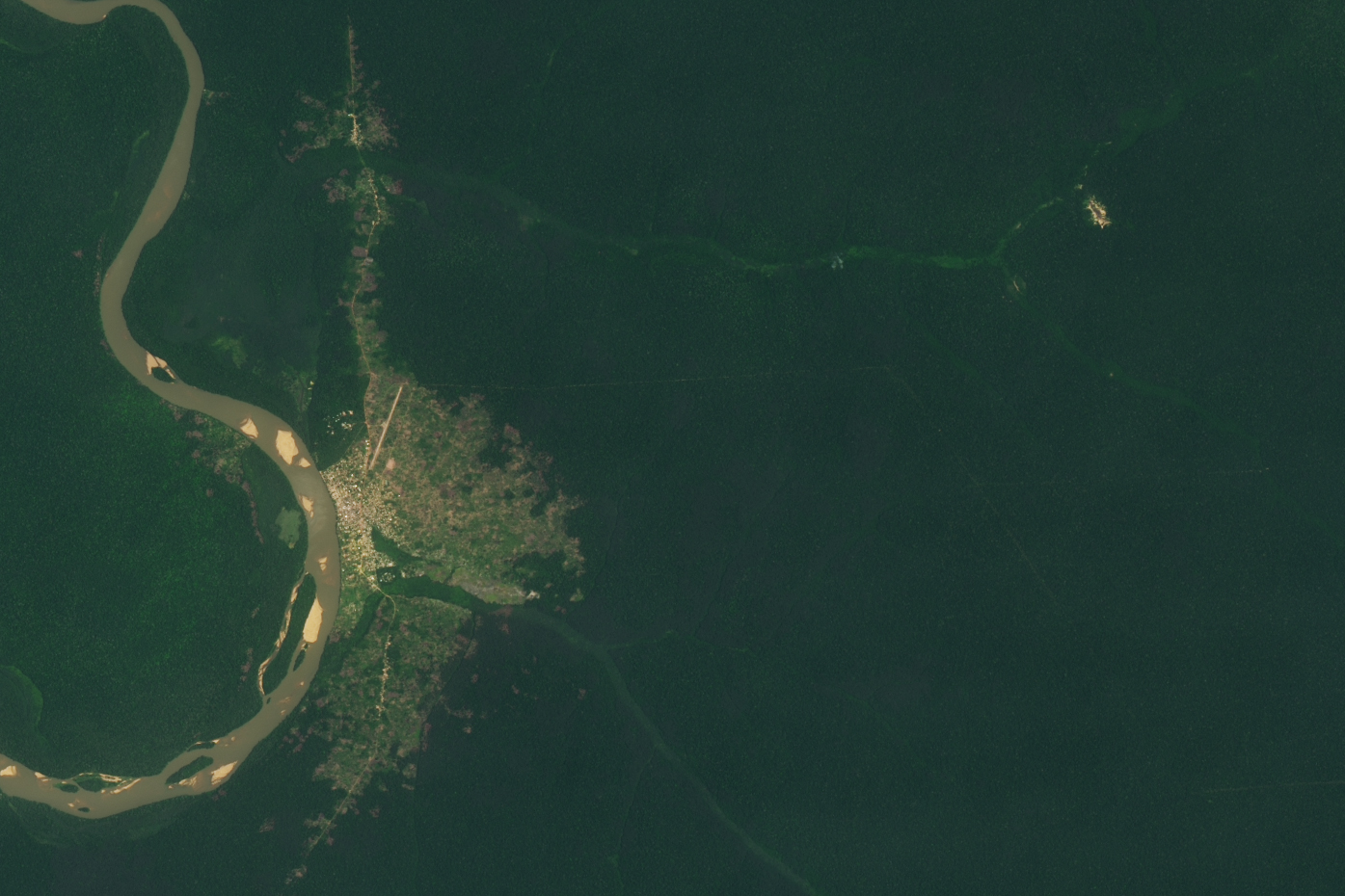
Amid the rainforests in the Central African Republic, there is a place where forest elephants have carved out a niche that is clearly visible from space. Known as Dzanga Bai, this swampy clearing attracts tens to hundreds of these massive herbivores every day.
Unique to the Congo Basin, bais are sandy and muddy open patches of forest that are pockmarked with puddles, streams, and watering holes full of mineral-rich water. Dzanga Bai is believed to have been cleared and maintained by African forest elephants that trample or eat much of the vegetation in this spot. The waters there are rich in minerals and salts that the elephants need but cannot obtain from rainforest vegetation. The minerals originate from an intrusion of volcanic rock (dolerite) not far below the land surface.
According to research led by biologist Andrea Turkalo of the Wildlife Conservation Society, anywhere from 50 to 150 forest elephants arrive at the bai each day, with several thousand living in the surrounding area. Using their feet, they dig holes in the surface down to the mineral-rich water in the substrate; sometimes they use their trunks to work their way through surface water to obtain minerals.
The Operational Land Imager (OLI) on Landsat 8 acquired these natural-color images of Dzanga Bai, the village of Bayanga, and the wider protected areas on March 28, 2021. For scale, Dzanga Bai is estimated to be about 500 meters (1,600 feet) long. The wider region is dominated by rainforest that is interspersed with streams, marshlands, and the bais. It all sits within the Congo Basin, the second largest rainforest in the world.
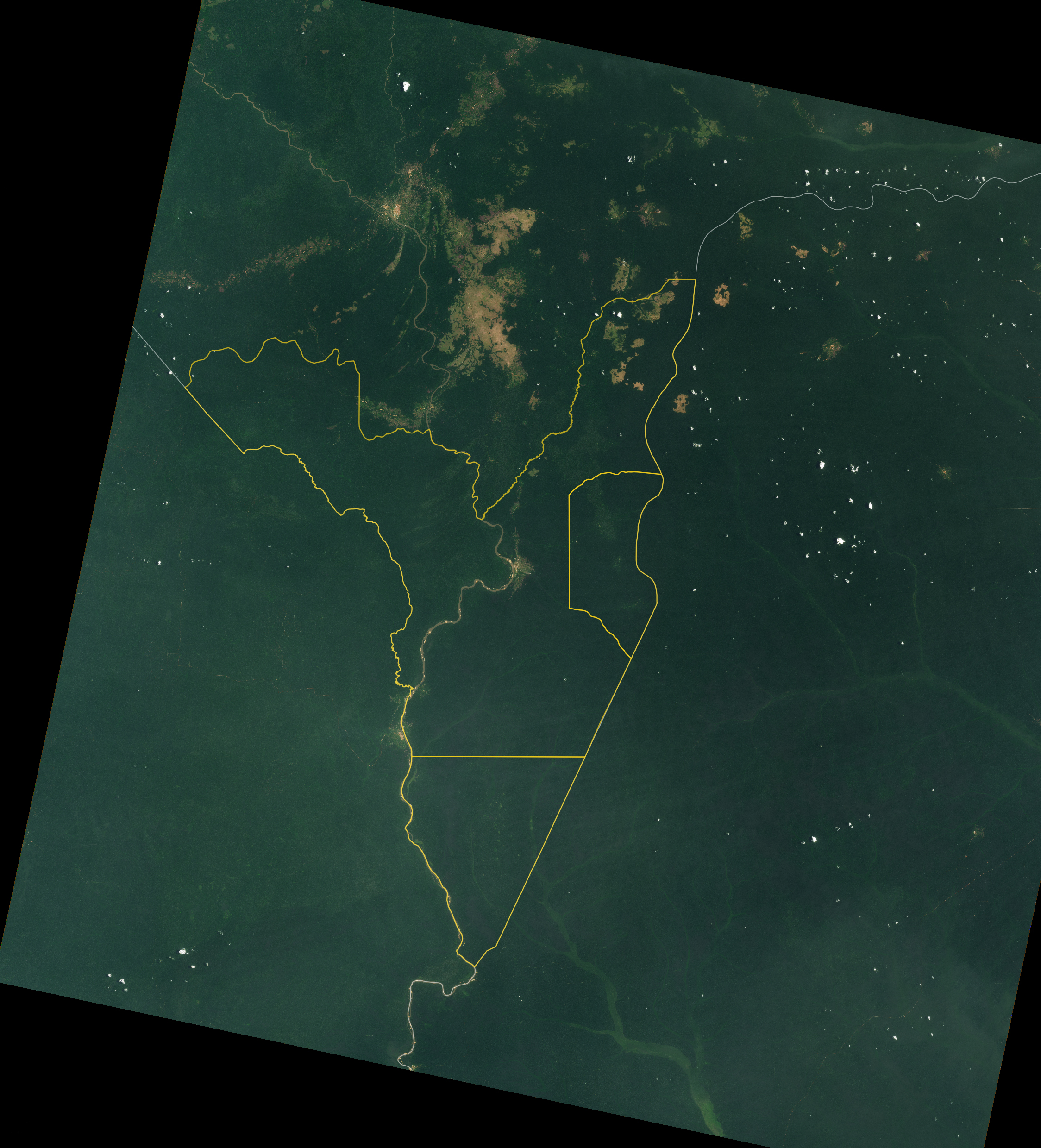
At this intersection between the Central African Republic, Cameroon, and the Democratic Republic of the Congo, governments and conservation groups have been working since 1990 to protect forestlands in a 17,000 square kilometer area called the Sangha River Trinational. UNESCO has declared the area—including Lobéké National Park (Cameroon), Nouabalé-Ndoki National Park (Republic of Congo), and Dzanga-Ndoki National Park (the Central African Republic), and the Dzangha Sangha Special Reserve (CAR)—to be a World Heritage Site.
Turkalo spent more than 25 years living and working in Dzanga-Ndoki National Park, producing a comprehensive natural history and demographic catalog of more than 1,600 known forest elephants at the bai. She found that male elephants have a lower survival rate, most likely due to hunting by humans looking to harvest ivory and bushmeat. Her long-term observations also revealed that forest elephants reproduce slower than the savannah species.
In an earlier study (Turkalo was a contributor), researchers estimated that the number of forest elephants in the Congo Basin declined by 62 percent between 2002 and 2011. The species lost about 30 percent of its geographic range, and the population was estimated to be less than 10 percent of its potential size. The elephants are not only threatened by poachers, but also by deforestation for logging and farming, and perhaps by exposure to disease from human contact.
Besides forest elephants, the region includes important habitat for the western lowland gorilla, the bongo (forest antelope), sitatunga (swamp antelope), forest buffalo, chimpanzees, and many species of birds. Indigenous Ba’Aka and Sangha Sangha people have lived in the area for thousands of years, using their knowledge of plants and traditional fishing techniques to sustain a culture in the rainforest.
NASA Earth Observatory images by Lauren Dauphin, using Landsat data from the U.S. Geological Survey and data from OpenStreetMap. Story by Michael Carlowicz.