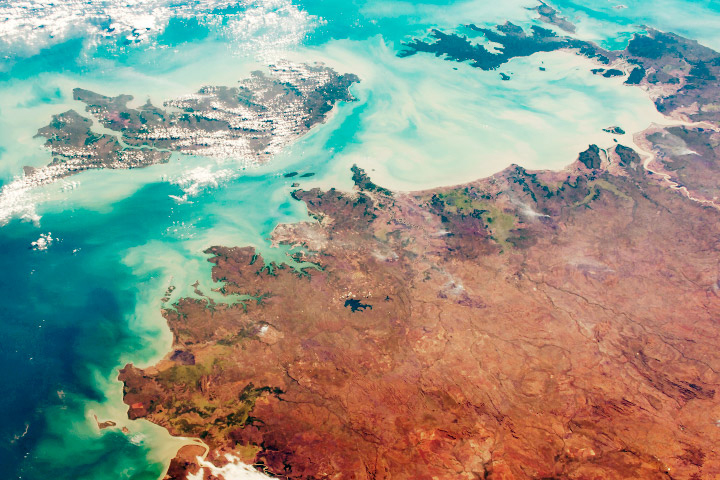
Editor’s note: This video explores the diverse landscapes and waterscapes near the coast of Queensland, Australia. The image was acquired on May 7, 2021, with the Operational Land Imager (OLI) on Landsat 8. Norman Kuring of NASA’s Ocean Biology group applied color-filtering techniques to draw out the fine details in the water, but the features are real. The following text is a transcript of the video.
The coastal region of North Queensland, in northeast Australia, displays an incredible variety of landscapes.
The diversity is apparent in this image, acquired in May 2021 with the Landsat 8 satellite. Note that some colors have been slightly enhanced to make parts of the landscape and ocean more distinct.
Here we highlight five features that stand out when viewing the area from space.
1. The Burdekin River
We start at Lake Dalrymple. The artificial reservoir, located about 100 kilometers from the coast, was formed in the 1980s by damming the Burdekin River. The dam is the largest in the state.
Following the Burdekin River northeast and then north from the reservoir, the river flows across a wide area of pastureland used for livestock grazing, primarily cattle.
Farther downriver we start to see the effects of irrigation. Water from the reservoir and from underground aquifers is distributed to farms, transforming the land into a patchwork of green fields.
2. Agriculture Across the Burdekin
Most of the farms pictured here are growing sugarcane. More than 800 square kilometers of the region, known as “the Burdekin,” are dedicated to the crop.
3. Urban Areas
Nestled between the sugarcane fields, two gray areas stand out. These are the towns of Ayr and Home Hill. Compared to the bustling port city of Townsville to the northwest, Ayr and Home Hill are smaller, rural communities.
Home Hill hosts an annual festival celebrating the start of the sugarcane harvest. Burdekin is one of the last regions in Australia where farmers burn sugarcane fields. This image, acquired in autumn, shows the area a few weeks before the season’s “first fire.”
4. Wetlands
The Burdekin River eventually reaches the coast at Upstart Bay. Here and elsewhere along the coast, sandy beaches and intertidal mudflats are interspersed with mangroves and salt marshes. Around Bowling Green Bay, a large swath of the coast is recognized as a wetland of international importance.
The wetland area also falls within the boundaries of Bowling Green Bay National Park. In addition to low-lying wetlands, the park extends inland and includes Mount Elliot. This rugged, forested area towers more than 1,000 meters over the coastal plain.
5. Great Barrier Reef Lagoon
Much of the water flowing down from Mount Elliot, from the Burdekin River, and from the wider watershed ultimately ends up in the Great Barrier Reef lagoon. Most of the turbidity pictured here—the brown water inland and the colorful plumes just offshore—are due to large seasonal tides.
The continuous ‘lines’ in the image are resuspension wakes from trawlers looking for various types of prawns. The longer, straighter lines are associated with shipping routes. These activities are strictly managed and monitored to protect the Great Barrier Reef Marine Park.
Farther offshore, Trichodesmium trace the complex patterns produced by the action of currents and tides downstream from the reefs. These eddies are important for trapping and retaining coral larvae and juvenile fish, which helps the reefs to self-seed and replenishes themselves with the next generation of life.
NASA image by Norman Kuring/NASA's Ocean Color Web, using Landsat data from the U.S. Geological Survey. Video by Kathryn Hansen with image interpretation of ocean features by Richard Brinkman/Australian Institute of Marine Science. Music (“Ambient Background Loop”) by Lv_Project.