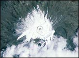
Glaciers covered most of the summit during the first half of the 20th century, but have shrunk dramatically since then.
Published Mar 25, 2001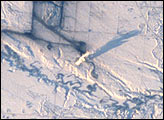
Snow and ice serve to accent human activities in this photograph taken by the Space Shuttle mission STS-98 crewmembers on February 17, 2001. The Souris River stretches across the photograph from left to right, with the upstream Rafferty Dam Reservoir frozen over on the far left. Two power plants, the Boundary Dam Power Station and the Shand Power Station, can be identified by the smoke plumes and shadows of those plumes. The river is frozen over upstream of the Boundary Dam Power Station, but thermal loading from the plants has warmed the water in the Boundary Dam Reservoir so that it remains nearly ice free. Downstream of the reservoirs, thermal loading is sufficient to maintain open flow in the Souris River.
Published Mar 18, 2001
his image shows a photograph of San Francisco taken as the International Space Station passed 383 km overhead on November 10, 2000. The view includes the area stretching from the Golden Gate Bridge in the north to the San Mateo Bridge on the southeast.
Published Feb 25, 2001

With much of their time committed to construction of the International Space Station, astronauts and cosmonauts are also beginning their first scientific studies. The Destiny Laboratory just joined to the International Space Station includes the best optical quality window ever flown on a human-occupied spacecraft. The window will eventually host a number of remote sensing experiments that will use a special rack system, the Window Observational Research Facility or WORF, for mechanical and electrical support (Eppler et al. 1996). Until the WORF is complete in June 2002, astronauts are photographing the Earth’s surface as part of an early project, Crew Earth Observations.
Published Feb 16, 2001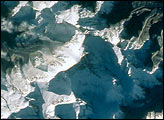
Mt. Everest is the highest (29,035 feet, 8850 meters) mountain in the world. This detailed look at Mt. Everest and Lhotse is part of a more extensive photograph of the central Himalaya taken in October 1993 that is one of the best views of the mountain captured by astronauts to date.
Published Feb 4, 2001
View of the Earth as seen by the Apollo 17 crew traveling toward the moon. This translunar coast photograph extends from the Mediterranean Sea area to the Antarctica south polar ice cap. This is the first time the Apollo trajectory made it possible to photograph the south polar ice cap.
Published Jan 31, 2001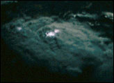
The top of the large thunderstorm, roughly 20 km across, is illuminated by a full moon and frequent bursts of lightning.
Published Jan 21, 2001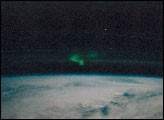
Astronauts aboard the STS-97 Space Shuttle mission in December photographed the northern lights after undocking from the International Space Station. TThe faint, thin greenish band stretching across and above the horizon is airglow; radiation emitted by the atmosphere from a layer about 30 km thick and about 100 km altitude.
Published Jan 14, 2001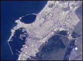
This image of Alexandria was taken by astronauts on board the International Space Station in December 2000 using an Electronic Still Camera.
Published Dec 31, 2000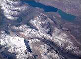
This scene on the remote, rugged Argentine/Chilean border in the far southern Andes Mountains offers numerous, dramatic examples of both erosional processes and features of ice and water.
Published Dec 24, 2000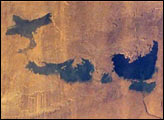
New lakes in southern Egypt have been monitored by astronauts since 1998. The flooding was first documented in early November 1998. Subsequently, three additional lakes were created by Lake Nasser overflow, as shown by the above photograph taken in December of 1999.
Published Dec 17, 2000
The STS-92 Space Shuttle astronauts photographed upstate New York at sunset on October 21, 2000. Water bodies (Lake Ontario, Lake Erie, the Finger Lakes, the St. Lawrence and Niagara Rivers) are highlighted by sunglint (sun reflecting off the water surface), making for a dramatic and unusual regional view.
Published Dec 10, 2000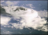
Astronauts used the Electrical Still Camera (ESC) to photograph a mass of storm clouds during Expedition 1.
Published Dec 3, 2000
This photograph taken from the Space Shuttle Discovery was taken at a slightly oblique look angle to better view air pollution and other atmospheric features. The photograph was taken with the Shuttle in a position over the Atlantic Ocean looking back toward the North Carolina and Virginia coast. On October 23, 2000, high pressure centered over the northeastern U.S. had created a capping inversion for aerosols. Forest fire smoke and industrial air pollution accumulated under the inversion. The inversion pattern is stronger inland, and the aerosols are being banked against the Piedmont. Relatively clear air is flowing from the ocean over the Carolina coastal plain. Small smoke plumes from individual fires can also be seen on the ground stretching from central Virginia to Raleigh, NC.
Published Nov 18, 2000