The Earth Observatory has published its last Image of the Day on this website. Please join us on our new home at science.nasa.gov/earth/earth-observatory.
| The Right Stuff | |||
Moran explains that a farmer, like any business person, needs good and timely information to succeed. To formulate an effective growing strategy, a farmer needs to know three things: (1) which conditions are relatively stable during the growing season; (2) which conditions change continually throughout the growing season; and (3) information to diagnose why their crop is thriving in some parts of the field and struggling, or even dying, in other parts. Increasingly, large-scale growers are using information gathered by aircraft and satellite-based remote sensors to help them gather these types of information. Early detection of any change in growing conditions is the key to
good crop management. While there is no match for a farmer’s own
firsthand observations, it isn’t always possible for large-scale
growers to survey all of their lands every week. In addition to
watching out for pests, such as weeds and insects, farmers must also
monitor variables like soil moisture and even plant disease
outbreaks. |
|||
A number of scientific studies over the last 25 years have shown that
measurements in visible, near-infrared, thermal infrared, and microwave
wavelengths of light can indicate when crops are under stress (Moran
2000). Using satellite- and aircraft-based remote sensors to precisely
measure the wavelengths of radiant energy that are absorbed and
reflected from the land surface, scientists can diagnose a wide range of
growing conditions. For instance, these data can tell farmers where
their crop is thriving and how efficiently the plants are
photosynthesizing. Alternatively, remote sensing data can tell not only
where, but why, their crop is under stress and help them diagnose
the source. |
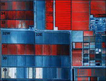
This false-color composite image of the Maricopa Agricultural Center, a research farm in central Arizona, was acquired in June 1996 by the Daedalus sensor flying aboard a NASA aircraft. The vegetation growing in the fields is mostly cotton and alfalfa. Bare fields appear blue, while soils that have recently been leveled in preparation for planting appear white. Dark red areas show flood irrigation (through the crop canopy), which can be seen in the eastern part of field 31. (Image courtesy Susan Moran, Landsat 7 Science Team) | ||
Satellites and aircraft have the added advantage of allowing farmers to survey their entire land in mere minutes. "In the early days, when farmers had small fields, they knew from practical experience which sub-areas were wetter and more fertile," notes Craig Daughtry, a research physical scientist at the U.S. Department of Agriculture in Beltsville, MD. "But as farms have grown from a few hundred acres to [as much as] 50,000 acres, farmers start to lose touch with their fields. Remote sensing provides a fabulous tool for looking at changes on small scales of space and time." Once farmers can correctly diagnose exactly where and when there is a problem, the next step is to correctly apply the treatment. |
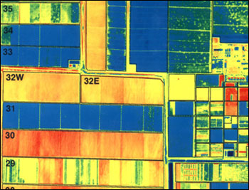
This false-color image shows the same scene as the image above, but it represents measurements made at thermal infrared wavelengths of the spectrum, to represent surface temperatures. Cool temperatures (blue and green) are associated with vegetation and hot temperatures (yellow and red) with bare soil. (Image courtesy Susan Moran, Landsat 7 Science Team) |