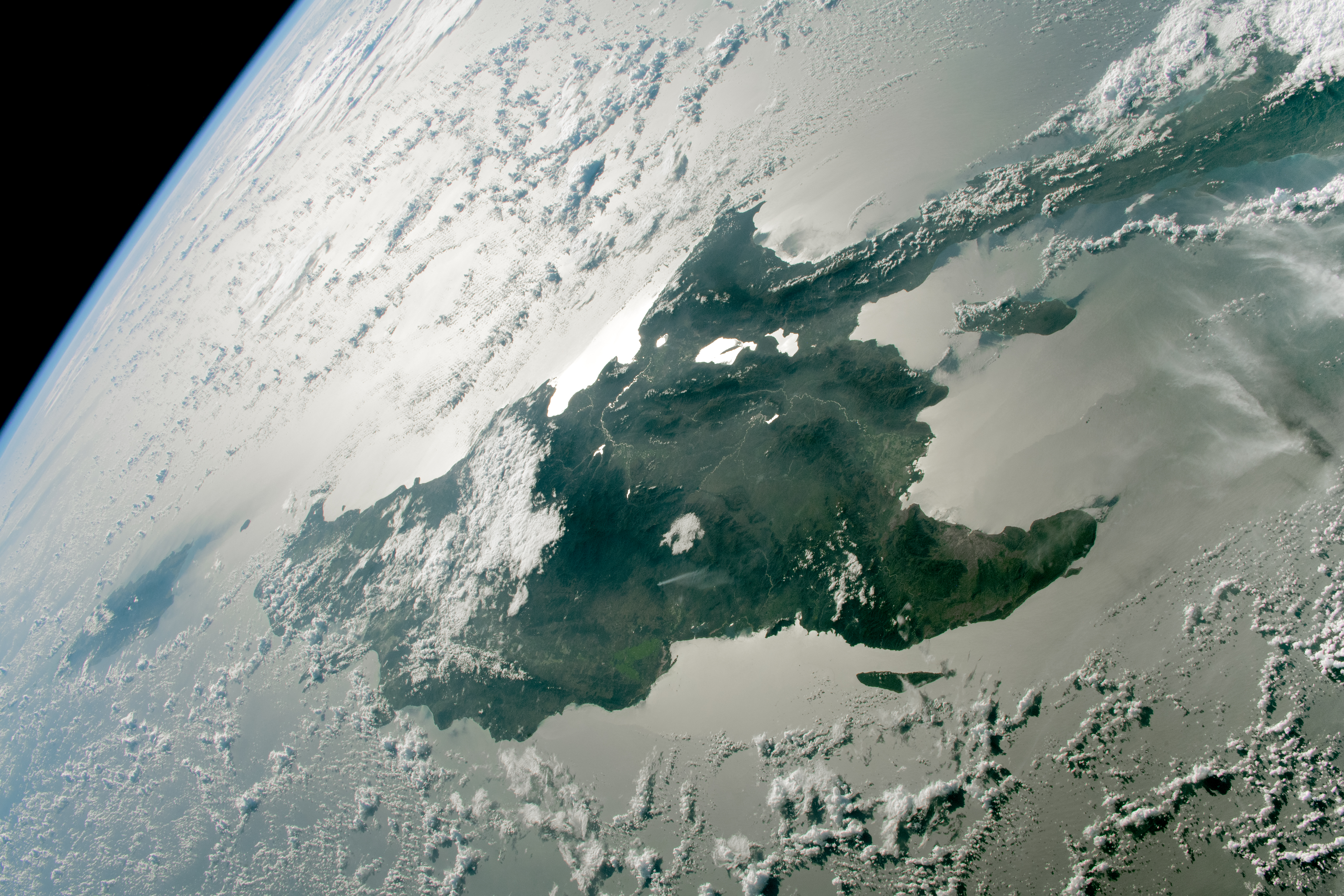
An astronaut aboard the International Space Station took this photograph of Hispaniola while in orbit over the Atlantic Ocean. Hispaniola is divided into two countries, Haiti to the west and the Dominican Republic to the east. The island is part of the Greater Antilles, a group of islands in the Caribbean Sea stretching from Cuba (out of frame to the right) to Puerto Rico (bottom-left of the image). In this view, north is toward the bottom-right.
The oblique angle of the photo reveals Earth’s upper troposphere and stratosphere, visible as the light-blue strip in the top-left corner of the image. Atmospheric phenomena, such as a plume of smoke over the north-central part of the island and various cloud types, also make an appearance.
Sunglint brightens virtually all water surfaces in this image, highlighting the island’s hydrography. Sunglint occurs when sunlight reflects from a water surface directly back to the observer, or in this case, the camera. The Artibonite and Yaque del Sur rivers are especially visible against the darker landscape as bright, thin lines. The calm waters of interior lakes, such as Lago Enriquillo and nearby Lake Azuéi, and coastal bays along the island’s south side appear bright white, as sunglint is stronger in places with calmer winds and smoother water surfaces.
Trails of clouds stream downwind from Gonâve Island, west of Hispaniola, and the Tiburon Peninsula farther to the southwest. Such clouds likely form when warm, less-dense air near the ground rises and condenses. Clouds can also be caused by the orographic effect, which occurs when mountains act as a natural barrier that prevents the passage of air masses. Mountains force the air to rise and cool, triggering water vapor to condense into clouds on the windward side of a mountain while leaving the leeward side drier. This effect is evident along the Cordillera Central, where clouds have formed on the east side of the mountain range (windward) and mostly clear skies prevail on the west side (leeward).
Astronaut photograph ISS068-E-36387 was acquired on January 2, 2023, with a Nikon D5 digital camera using a focal length of 50 millimeters. The image was provided by the ISS Crew Earth Observations Facility and the Earth Science and Remote Sensing Unit at Johnson Space Center. The image was taken by a member of the Expedition 68 crew. It has been cropped and enhanced to improve contrast, and lens artifacts have been removed. The International Space Station Program supports the laboratory as part of the ISS National Lab to help astronauts take pictures of Earth that will be of the greatest value to scientists and the public and to make those images freely available on the Internet. Additional images taken by astronauts and cosmonauts can be viewed at the NASA/JSC Gateway to Astronaut Photography of Earth. Caption by Wilfredo García López/Jacobs-JETS II Contract at NASA-JSC.