
Holla Bend, a refuge along the Arkansas River, benefits bunches of babbling birds.
Published Jan 3, 2016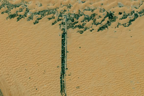
What begins with T? Taal, Tolbachik, and trees amidst this tan terrain.
Published Jan 1, 2016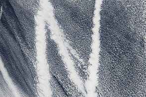
Nimbus and nuclei and the near-infrared all bring us earth science joy.
Published Dec 31, 2015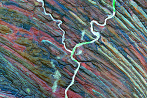
What starts with Y? Yellowstone, the Yukon Delta, and the Yellow Sea.
Published Dec 26, 2015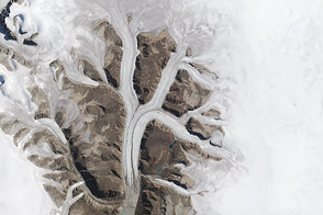
Keen to see K from space? See what satellites have have kindly revealed.
Published Dec 24, 2015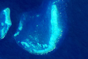
J brings us joy when we view it from space.
Published Dec 23, 2015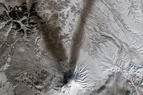
Ash paints the snow to the northwest and northeast of Russia’s Shiveluch volcano.
Published Mar 26, 2015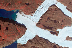
Crisscrossing glaciers in northwest Greenland flow along the path of least resistance.
Published Jan 22, 2015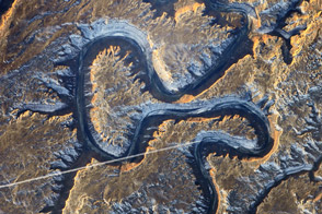
The Green River in eastern Utah once carved soft sediment into meanders on a floodplain. Then the land and mountains rose and the river dug deep, preserving those meanders in stone.
Published Mar 17, 2014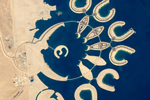
At the southern end of Bahrain Island, at the furthest point from the cities of the kingdom, a new complex of 14 artificial islands has risen out of the sea.
Published Feb 7, 2011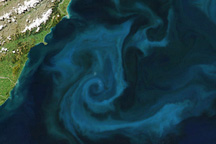
A phytoplankton bloom colored the waters east of New Zealand on October 25, 2009.
Published Oct 28, 2009
Scraped clean and weighted down for thousands of years by Pleistocene ice sheets, Akimiski Island in James Bay provides a case study of how Earth's land surfaces evolve following glaciation. During the last ice age, this small island was buried under several thousand meters ice, but since its retreat, the island has rebounded (risen in elevation) and new beach areas have emerged, streams and lakes have formed, and trees and other vegetation have colonized the new territory.
Published Apr 15, 2008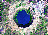
India’s Lonar Crater began causing confusion soon after it was identified. Lonar Crater sits inside the Deccan Plateau—a massive plain of volcanic basalt rock leftover from eruptions some 65 million years ago. Its location in this basalt field suggested to some geologists that it was a volcanic crater. Today, however, Lonar Crater is understood to result from a meteorite impact that occurred between 35,000 and 50,000 years ago.
Published Apr 13, 2008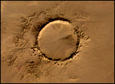
Deep in the Sahara Desert lies a crater. Nearly a perfect circle, it is 1.9 kilometers (1.2 miles) wide, and sports a rim 100 meters (330 feet) high. Modern geologists long debated what caused this crater, some of them favoring a volcano. But closer examination of the structure revealed that the crater’s hardened “lava” was actually rock that had melted from a meteorite impact.
Published Feb 17, 2008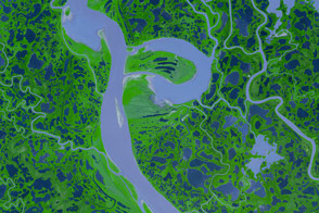
Canada’s Mackenzie River, the country’s longest, spills out of Great Slave Lake, just north of the border between Alberta and Northwest Territories.
Published Dec 20, 2007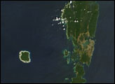
The Andaman Islands consist of more than 500 islands in the Bay of Bengal. The largest islands comprise Great Andaman, easily seen from space.
Published Feb 15, 2007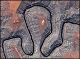
The image shows Goosenecks State Park, where the river is surrounded by canyon walls more than 1,000 feet high.
Published May 13, 2005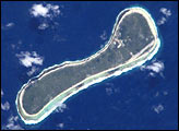
These two images of the Tuamotu Archipelago, French Polynesia, illustrate diversity in the morphology of atolls, one of the major types of coral reef formations. A typical atoll structure is a lagoon surrounded by a closed rim of cays and shallow spillways that control the exchange of water between the ocean and the lagoon. However, like human beings, this general scheme may vary according to the history of each individual atoll, resulting in a high diversity of morphology, especially for small atolls. The two neighboring atolls shown here have some unique features. What was a lagoon on Nukutavake (19°17′ S 138°48′ W, 6.2 km²) is now dry and completely covered by vegetation. Pinaki (3.54 km²) has a drying shallow lagoon still connected to the ocean via a single narrow spillway. The variation of morphology implies that each atoll may have a different equilibrium between ocean, lagoon, and land ecosystems.
Published Jul 1, 2001