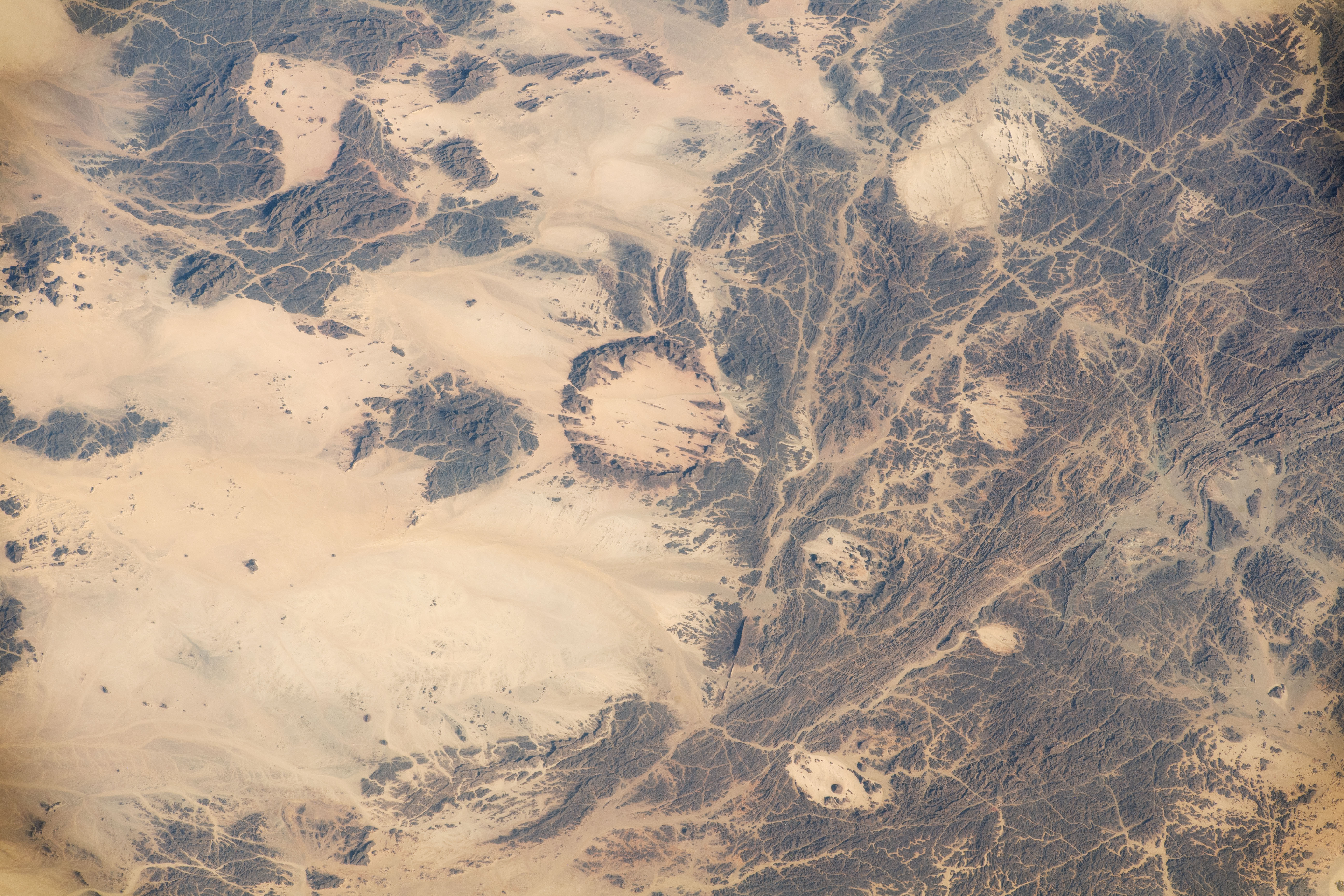
An astronaut aboard the International Space Station took this photo of a remote part of the Sahara Desert known as the Red Sea Hills, approximately 240 kilometers (150 miles) west of the Red Sea. This rugged topography reaches altitudes of 650–800 meters (2100–2600 feet) above sea level. The exposed rock surfaces of the hills on the right appear dark because they are coated with a thin film known as desert varnish. This type of mineral coating commonly appears on rocks in hot deserts.
In contrast to the hills, the landscape on the left side of the image is relatively flat, light in color, and at lower altitudes of 420–520 meters (1380–1720 feet). Here, dune sands composed of the mineral quartz blanket the ancient geological structures beneath.
Geologic maps of the hills show a combination of major linear features known as shear zones and circular features described as ring complexes. Geologists have determined that these structures, part of the Hamisana Shear Zone in northeastern Sudan, were formed at the time of the assembly of the great continent Gondwanaland. The dark rocks of the hills are all intrusive igneous rocks—specifically, granites and syenites—of Proterozoic age that were emplaced when an ancient sea called the Mozambique Ocean slowly closed between 750 and 610 million years ago.
Ring features can appear when molten rock intrudes through surrounding rock, cools, and becomes exposed to view by erosion. On the ground, these complexes can be impressive landforms. The steep outer wall of the ring in the center of the image rises 250 meters (840 feet) above the central depression. Its diameter measures approximately 15 kilometers (9 miles). The ring complexes in the view result from intrusions dated at 624 million years old. To put that in perspective, the main section of the relatively young Red Sea began to open only about 20 million years ago.
Astronaut photograph ISS067-E-10371 was acquired on April 12, 2022, with a Nikon D5 digital camera using a focal length of 200 millimeters. The image was provided by the ISS Crew Earth Observations Facility and the Earth Science and Remote Sensing Unit, Johnson Space Center. The image was taken by a member of the Expedition 67 crew. It has been cropped and enhanced to improve contrast, and lens artifacts have been removed. The International Space Station Program supports the laboratory as part of the ISS National Lab to help astronauts take pictures of Earth that will be of the greatest value to scientists and the public, and to make those images freely available on the Internet. Additional images taken by astronauts and cosmonauts can be viewed at the NASA/JSC Gateway to Astronaut Photography of Earth. Caption by Justin Wilkinson, Texas State University, JETS Contract at NASA-JSC.


