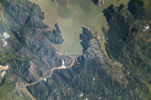

Long-term drought and aggressive seasonal wildfires have consumed property, lives, and farmland in the American West. The dry weather and blazes are battering regional economies and putting residents and agricultural businesses in several states on a path toward water restrictions. At least part of this story of water woes lies underground.
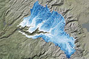
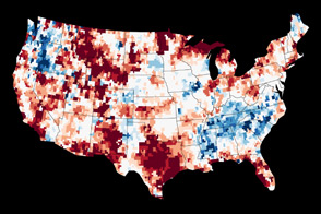
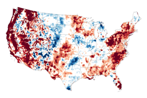
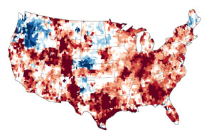
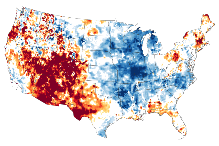
The map above combines data from the satellites of the Gravity Recovery and Climate Experiment (GRACE) with other satellite and ground-based measurements to model the relative amount of water stored in underground aquifers in the continental United States. The wetness, or water content, is a depiction of the amount of groundwater on July 7, 2014, compared to the average from 1948 to 2009. Areas shown in blue have more abundant groundwater for this time of year than comparable weeks over the long-term, while shades of red depict deficits compared to this time of year.
The maps are an experimental product used by the U.S. Drought Monitor and supported by NASA’s Goddard Space Flight Center. The measurements are derived from observations of small changes in Earth’s mass and its gravity field—features that are affected by the movement and storage of water and ice around the planet.
The extent of drought in the American Southwest are reflected well in the GRACE map. California, Nevada, New Mexico, Colorado, Texas, Arizona, Oklahoma, and Nebraska have been suffering from various degrees of long-term drought that has parched the land surface and prevented the replenishing of groundwater below.
However, some other odd juxtapositions appear. The Pacific Northwest states of Oregon and Washington are suffering through raging wildfires, as months of hot weather have dried out forests. But according to the groundwater data, conditions underground are normal to wet—likely a reflection of the long lag between the accumulation and depletion of water underground and the changes in conditions on the surface. Those states had very wet winters, but the heat and dryness of spring and summer have not yet penetrated the underground storage.
A new study by scientists from NASA and the University of California–Irvine (UCI) has found that more than 75 percent of the water lost since 2004 in the drought-stricken Colorado River Basin has come from underground sources. Published online on July 24, 2014, the study is the first to quantify the amount that groundwater contributes to the water needs of the western United States.
According to the U.S. Bureau of Reclamation, the Colorado River basin is now in the driest 14-year period in the past hundred years. Using monthly measurements from GRACE between December 2004 and November 2013, the researchers found that the basin lost nearly 53 million acre feet (65 cubic kilometers) of fresh water, almost double the volume of the nation’s largest reservoir, Lake Mead. More than three-quarters of that loss came from groundwater supplies. (Water above ground in rivers and lakes is managed and documented by the Bureau of Reclamation.)
“We don't know exactly how much groundwater we have left, so we don't know when we're going to run out,” said Stephanie Castle, a water resources specialist at UCI and the study’s lead author. “This is a lot of water to lose. We thought that the picture could be pretty bad, but this was shocking.” The Colorado River basin supplies water to about 40 million people in seven states and irrigates roughly four million acres of farmland.
Looking specifically at California and over a shorter time span, researchers from the University of California–Davis (UCD) reported on July 15 that the state’s rivers are only providing about one-third of the usual amount of water that is supplied to farmers (a deficit of about 6.6 million acre-feet). California has been making up for the loss by pumping about 5 million acre-feet of groundwater. The UCD team reported that the current drought has had an economic cost of at least $2.2 billion so far in 2014, including the loss of 17,000 farm-related jobs. About 5 percent of the irrigated farmland has been taken out of production.
“What will it take to get out of this drought in California? In the past, that has been a difficult question to answer,” said Jay Famiglietti, a water cycle scientist based at NASA’s Jet Propulsion Laboratory. “With some of our recent research using GRACE to quantify the magnitude of the drought deficit at any point in time, we can now begin to estimate just how much water we need to satisfy that deficit. For example, as of January 2014, we could see that the Sacramento and San Joaquin River basins were 25 cubic kilometers below normal conditions for that time of the year. That's exactly how much water we would need to alleviate drought conditions.”
“That's the long answer,” Famiglietti added. “The short answer is that we’re going to need several successive winters of above-average rainfall to dig out of that hole.”
Maps by Chris Poulsen, National Drought Mitigation Center at the University of Nebraska-Lincoln, based on data from Matt Rodell, NASA Goddard Space Flight Center, and the GRACE science team. Caption by Mike Carlowicz.