Sentinel Gets Its Start |
|||
The Sentinel project has a lot in common with a similar project developed in the United States by scientists at Goddard Space Flight Center (GSFC), the University of Maryland, the National Oceanic and Atmospheric Administration (NOAA), and the U.S. Department of Agriculture Forest Service. Known as the MODIS Rapid Response Project, it provides near-real-time fire detection from MODIS to the National Interagency Fire Center in Salt Lake City, Utah, where fire management and resource allocation decisions for the U.S. are made. The parallels between the two projects aren’t coincidence. Scientist Chris Justice of NASA-GSFC and the
University of Maryland leads the Rapid Response Project, which was designed as a prototype system to
demonstrate MODIS’ ability to detect active fires all over the world. Through theGlobal Observations for Forest and
Land Cover Dynamics project, the Rapid Response group “had been working to make the
international fire science community familiar with the MODIS Rapid Response system and what it could
offer to researchers across the world,” says Justice. Australia’s Sentinel Project was just the kind of
endeavor they hoped to motivate. |
|||
Among those motivated was Alex Held, a principal research scientist with the land and water division at
CSIRO. He’s a team leader for a group that specializes in environmental remote sensing. “The idea for
our Sentinel Hotspots project started during last year’s devastating fires around Sydney, where we began
looking at the NASA Rapid Response Website, which provided us next-day, MODIS-derived imagery for areas
of Australia. Rather than relying on day-old data,” explains Held, “we figured that with the right level
of automation, we could use the MODIS direct broadcast data to provide the coordinates for the detected
hotspots on a publicly-available Website much faster—within an hour of MODIS data download in Alice
Springs.” |
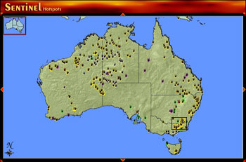
At theSentinel Hotpots Website, anyone can create maps of active fires detected by MODIS. Sentinel integrates fire detections with maps of geographic features. Each feature exists as a separate map layer, and users decide which features to display on their maps. This technique is called Geographic Information Systems (GIS) mapping. Users can get more detail by outlining an area of interest (black box) and refreshing the map. | ||
Held and his colleagues began discussions with the Rapid Response Project and John Guthrie from the U.S. Geological Survey, whose Web-based Geographic Information Systems (GIS) mapping tool, GEOMAC, had incorporated the MODIS fire detections as Held hoped to do with the Sentinel Project. The MODIS Rapid Response Project provided computer software for analyzing the MODIS direct broadcast signal and identifying hot spots and advised the fledgling project on purchasing and installing commercial software packages that would serve as the foundation of Sentinel’s Web-based GIS interface. From this international collaboration, and with additional funding from Australia’s Defense Imagery and Geospatial Organization, the Sentinel Hotspots project began to materialize. |
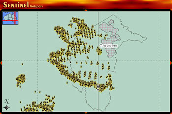
The image at left shows the fires detected around Canberra between January 14 and 17, 2003, along with latitude and longitude lines, the boundary of the Australian Capital Territory (larger gray outline), and the urban limits of the city of Canberra (small gray outline filled with cross-hatching). Other GIS layers that users can choose from (not shown) include rivers and lakes, railroads, topography, and highways. |