 |
by Rachel Hauser June 2, 2000 |
||
|
Mystery shrouds the Antarctic continent, particularly its eastern interior where few humans have explored. Satellite images obtained in 1997 for the RADARSAT Antarctic Mapping Project (RAMP) culminated in the world's first high-resolution map of Antarctica and completed the terrestrial mapping of the globe.
|
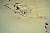
Bottom: Beneath 10 feet of snow and ice, a bright glimmer on a satellite image betrays the location of a forgotten 1,400 foot skiway on the world's frozen continent. The skiway, abandoned in the 1950s, reappeared late last year in one of many images produced by the RADARSAT Antarctic Mapping Project (RAMP). Collected during a month-long window of opportunity scientists hope the RAMP pictures will improve existing knowledge of the effects of climate variability on Antarctica and shed light on its geology and glaciology. For Researchers |
What began as a plan to map sea ice in the Arctic evolved into a multinational effort to create the first high-resolution map of the Antarctic when Canada and the United States teamed to launch RADARSAT.
The original scheme did not include mapping Antarctica. Canada's interest, spurred by the 1970s oil crisis, lay in identifying areas of sea ice off of its eastern coast to solve the problem of getting oil, coal and minerals safely out of the Arctic. Using then newly acquired SAR expertise to detect sea ice in the Arctic quickly and accurately, the government looked to satellite technology, said Ed Langham, director of satellite operations for the Canadian Space Agency (CSA). CSA invited NASA to join in the initial mission requirement studies. During this process, the two agencies decided that NASA would launch the satellite in exchange for certain data rights. "NASA was interested in mapping Antarctica. In return for launch, NASA would receive a certain amount of data, and CSA would map Antarctica," said Kenneth Jezek, director of Byrd Polar Research Center at Ohio State University and RAMP's principal investigator. The agreement meant that CSA would have to change the original design of the spacecraft. "Initially, the satellite could not have taken pictures of the Antarctic because the radar looks to one side and that side was pointing north to obtain good coverage of Arctic sea ice. We redesigned the satellite so that it could be turned around and flown backwards, as it were, with the radar beam pointing to the other side. That effectively reversed the north-south perspective of the system," said Langham. All of the technical planning and design that led up to and included data acquisition fell under the auspices of the Antarctic Mapping Mission (AMM). "RAMP and AMM had to be separated because tasks that had to do with data acquisition really had nothing to do with the mapping project," said Nettie Labelle-Hamer, coordinator of AMM at the Alaska SAR Facility. The complexity of the mapping mission called for a multi-team approach. The Jet Propulsion Laboratory (JPL) developed the data acquisition plan, the Alaska SAR Facility (ASF) turned digital data into preliminary images and processed the final scientific-quality data, Vexcel built the system to process the imagery to geometrically accurate Antarctic views, and Byrd Polar Research Center created the map by stitching the images together. Preparation for the mapping mission began in August 1993. JPL brought in John Crawford, a staff scientist, to design the data acquisition segment of the mission. Several obstacles faced Crawford, including lack of mission planning software and limited data storage on board the satellite. Typically, data are dumped after each orbit at receiving stations but two out of every 14 orbits were not close enough to dump the data. Consequently, lack of adequate on-board data storage became problematic. "RADARSAT in its normal, north-looking mode cannot image south of 78 degrees. It was essential to ensure data collection for every single orbit in that huge region around the pole where normally the radar would not see. Of particular glaciological importance were images of the Transantarctic Mountains, Siple Dome, and the Ross Ice Shelf," said Crawford. RAMP officially started September 26, 1997, the end of the Antarctic winter. This start time promised little occurrence of environmental change during the mission. Arctic freeze-up also begins in September and the switch to south-looking mode meant no sea ice data were available in the high latitudes of the Arctic. The Canadian Space Agency, wanting to show that they could perform the mission and still accommodate the majority of their customers, wanted to reduce the number of days RADARSAT collected Antarctic data during the mapping mission. CSA allowed 18 days for data collection with time built in for contingencies. The collection procedure proved more efficient than anyone could have hoped, said Crawford. "The planning of the project was very precise because we were trying to achieve all of the different science requirements within all of the engineering constraints of the mission." RADARSAT was maneuvered into a south-looking position on September 9 and testing began a few days later. "Once the spacecraft was off the ground, everything worked perfectly, so data collection began immediately and continued through October 14," said Greta Reynolds, Alaska SAR Facility's Acquisition Planning Supervisor. "A second unforeseen period of data gathering occurred at the end of the mission when days planned as contingency became available for data collection." Throughout the study period, the Alaska SAR Facility operated 24 hours per day, seven days per week, with a full staff receiving and verifying the data. "We had to do a 'quick look process', which is not a final product, but gave us a rough sketch to see if the satellite covered what we thought it would, and to make sure we got everything that we thought we would get," said Labelle-Hamer. "In the event of data problem, we only had three days to reprogram the spacecraft before the data were lost, and it took two of those to get the data downloaded, verified and pre-processed," said Marc Forbes, ASF's Operations Center Supervisor. The Alaska SAR Facility processed the raw data into preliminary 'quick-look' images and sent them to Byrd Polar Research Center where the individual images were compiled into a mosaic using a processing system developed by Vexcel Corporation. The first round of data arrived at Byrd Polar in January 1998. In 1999, the extended collaboration realized payoff in a remarkable depiction of the continent as it appeared during the fall of 1997. "Not only was RAMP good science," Jezek said, "the project demonstrated a wonderful international collaboration." |
|