 | |||
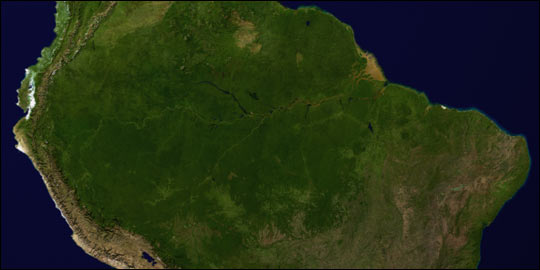
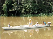
With tributaries extending from the vast savannas to its north and south, the Amazon River runs almost 4,000 miles (1 mile equals 1.6 kilometers) across northern South America from the highland biomes in the foothills of the Andes Mountains to the Atlantic Ocean. It carries twenty percent of all river water discharged into Earth’s oceans—ten times the volume of the Mississippi River. If the Amazon River Basin were draped over the continental United States, it would cover more than three fourths of the country. |
| ||
| |||
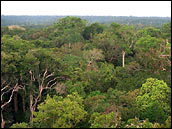
From December to May each year, torrential rains and snow melt from the Andes increase the main river channel’s depth 30-45 feet (9 to 14 meters), and water backs up in tributaries and inundates forest several miles from the main channel. In the central Amazon Basin alone, the flood waters can cover an area up to 97,000 square miles. The river and the flooded forests then come together as a giant, slow-moving swamp. Surrounding these waters are over 2.7 million square miles (7 million square kilometers) of lush forest exploding with life. In fact, perhaps as much as one half of all life forms on the planet live in the Amazon River Basin. The Amazon is more than a habitat, however; it is also a climate regulator. Located near the equator, where the sun’s daily rays are most intense, the uninterrupted expanse of lush vegetation absorbs incoming radiation and keeps things cool. The forest also absorbs and stores moisture. The Amazon forest canopy is so dense and so biologically productive that scientists have also recognized the region as a key component of the global carbon cycle. The continent-spanning tracts of forest inhale tons of carbon dioxide during photosynthesis and exhale oxygen. With respect to carbon, however, these forests aren’t all take. Through deforestation, decomposition, respiration, and export of organic and inorganic matter to the oceans, they also give. And then there’s the rain. The Amazon Rainforest engages in a perpetual, self-watering cycle by storing and recycling at least one-half—some scientists think perhaps even two-thirds—of the regional rainfall. This rain is more than just recycled water—it is the ecosystem’s mechanism for venting the tremendous amount of heat it collects and stores every day. Earth’s ongoing attempt to redistribute the intense radiation and heat it receives at the equator across the entire planet is the driving force of climate. Much of that redistribution occurs within the Earth’s oceans. But the atmosphere is also engaged in a continuous process of spreading the heat around the globe, and tropical rainfall drives the process. The intense solar radiation reaching the Earth at the equator provides the energy needed to evaporate huge volumes of water from both the ocean and land surfaces. The water vapor released into the atmosphere stores within it the heat energy that was required to turn liquid water to water vapor. So what happens to all that latent heat? It’s released back into the atmosphere when water vapor condenses into clouds and rain. Given that more than 9 feet (2.7 meters) of rain fall in portions of Amazonia each year, we are talking about a lot of heat. In fact, 75 percent of the energy that drives atmospheric circulation comes from the heat released during tropical rainfall. |
| ||
| |||
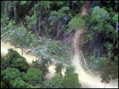
Because the dynamics of the Amazon River Basin play a major role in environmental conditions that affect the whole Earth, changes in climate and land use in the Amazon take on global importance. During the past 15 years more than 190,000 square miles (1 square mile is about 2.6 square kilometers) of forest have been cleared in the Amazon Basin, and 7,700 square miles are now being cleared each year. Hundreds, perhaps thousands, of future plants, animals, mushrooms, and insects have already been lost. Deforestation alters the ancient forests’ exchanges of water, carbon, and energy with the atmosphere—cycles that even now, we only partially understand. What are the impacts of land cover change in Amazonia both locally and globally? In 1993, the Brazilian science community, joined by an international team of scientists, began to plan a continental-scale study to answer that question. They established the Large-scale Biosphere-Atmosphere Experiment in Amazonia (LBA) to study how Amazonia currently functions as a regional entity within the larger Earth system, and how changes in land use and climate will affect the biological, physical, and chemical functioning of the region’s ecosystem. |
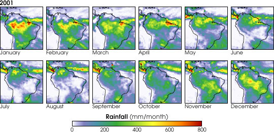
Located on the equator, Amazonia has a rainy season and a dry season, instead of the four seasons of temperate latitudes. The rainy season starts in the south in December, and gradually moves north through May. During this time the rains swell the rivers of Amazonia, creating extensive wetlands. (Images by Robert Simmon, based on data from the Global Precipitation Climatology Project) | ||
| |||
The project, which is led by the Brazilian Ministry of Science and Technology, began in 1998 and today consists of 100 coordinated research groups involving about 600 scientists from South and North America, Europe, and Japan. With the Amazon as their laboratory, the scientists are studying climate, atmospheric chemistry, the carbon cycle, nutrient cycling, land surface hydrology and water chemistry, land use and land cover, and the interaction of humans with the landscape. NASA’s Terrestrial Ecology and Land Use-Land Cover Change Programs participate in LBA through their sponsorship of LBA projects called LBA-ECO (formerly LBA-Ecology). As LBA is completing its fourth year, there are some exciting new results, so check back here often as the Earth Observatory presents a series of feature articles based on some of the project’s most significant findings to date: the discovery of a large source of carbon dioxide emissions within an ecosystem long thought to be a carbon sink; the impact of development and progress on the rainforest’s flammability; and the cloud and rainfall characteristics that have led some scientists to dub the forests “the green ocean.”
The data used in this study are available in one or more of NASA's Earth Science Data Centers. |
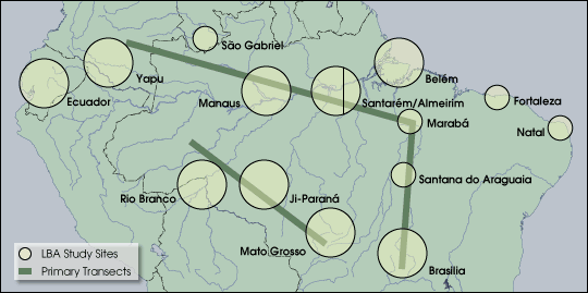
LBA sites span the Amazon from the headwaters in the Andes, along the river and its tributaries in the Amazon Basin, to the River’s mouth in coastal Brazil. (Map courtesy LBA science team, adapted by Robert Simmon) | ||