 |
|||
|
February 14, 2000 During the 6 p.m. news reports on Jan. 24, local meteorologists in the Washington, D.C., region forecasted "snow flurries" to begin around noon the next day with "up to an inch of accumulation on the ground." That was the last forecast many D.C. residents heard before going to bed that evening. But on Tuesday morning, Jan. 25, they awoke to find near blizzard conditions outside with 4 to 7 inches of accumulation already on the ground; and the winter storm wouldn’t subside until about 11 p.m. that night. In all, some areas east of Washington, D.C., received as much as 18 inches! Living in the United States, we have grown accustomed to weather forecasts that are highly accurate as much as three days ahead of time. So why didn’t meteorologists foresee the winter bomb Mother Nature was preparing to drop on most of the eastern United States? Actually, they did says Dave Jones, meteorologist for NBC’s WRC-TV and principal investigator for WeatherNet4. "The [computer] model runs on Wednesday, Thursday, Friday, and Saturday (Jan. 19-22) were indicating the potential for a major East Coast storm," Jones states. "But for some reason on Sunday and the early run on Monday (Jan. 23-24), the models did not continue to show a strong storm hitting the East Coast." Jones isn’t sure why the models backed off after so many consecutive days of predicting the storm would hit us. He suspects there may have been some critical data that were needed that somehow either weren’t collected or weren’t entered into the model. |
 Kids up and down the East Coast woke up to a pleasant surprise on January 25, 2000—several inches of fresh snow. Even though the storm went on to dump up to 18 inches of snow on several major cities, forecasts as late as 6:00 Eastern Standard Time the previous evening only called for flurries. (Photograph copyright Barbara Summey) | ||
 | |||
Meanwhile, all day Monday, TV meteorologists displayed satellite images of a huge cloudbank enveloping most of Georgia and North and South Carolina. Radar images revealed a vast blob of precipitation (mostly snow) being dumped on those states at a rapid rate of accumulation on the ground. If the storm moved north and east, there were implications for some of the busiest, most densely populated regions in the United States–Richmond, Washington, Baltimore, Philadelphia, New York, and Boston. But the question remained: What precisely would be the storm’s path? Forecasters throughout the United States were all examining the potential for this storm and knew that it could be a major event, according to Louis Uccellini, director of the National Centers for Environmental Prediction for the National Weather Service (a part of the National Oceanic and Atmospheric Administration, NOAA). Their challenge was to accurately predict its path. If the storm traversed 50 or 100 miles to the east--as the models were indicating--it would have very little impact on our roads and cities. But if the storm took a more westerly route, then forecasters knew we could be describing the accumulation in feet, not in mere inches. |
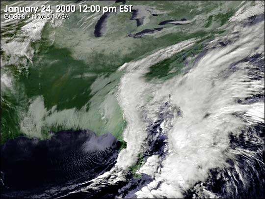
On January 24 and 25, 2000, a major winter storm moved
up the East Coast. Even though North Carolina was being blanketed by snow and ice all day Sunday, computer-generated forecasts predicted
the storm would miss the cities of the Northeast corridor. On Monday, however, Washington, DC, Philadelphia, New York, and Boston all received
significant snowfall. At times, the storm approached blizzard-like force. (Image by Marit Jentoft-Nilsen, NASA GSFC Visualization
Analyses Lab, based on data from NOAA) View: low
quality animation (1.5 MB) | ||
