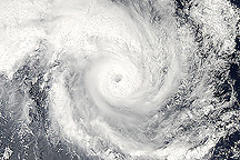
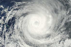
As of January 11, 2010, Tropical Cyclone Edzani had weakened considerably, with maximum sustained winds of 45 knots (85 kilometers per hour) and gusts up to 55 knots (100 kilometers per hour). The U.S. Navy’s Joint Typhoon Warning Center reported that the storm was roughly 970 nautical miles (1,800 kilometers) east-southeast of La Réunion and was moving slowly toward the south-southeast.
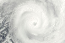
The Moderate Resolution Imaging Spectroradiometer (MODIS) on NASA’s Terra satellite captured this image of Edzani over the open ocean at 10:55 a.m. Calcutta time (5:25 UTC) on January 9, 2010. Hovering over the South Indian Ocean, Edzani spans hundreds of kilometers.
NASA image by Jeff Schmaltz, MODIS Rapid Response Team, Goddard Space Flight Center. Caption by Michon Scott.