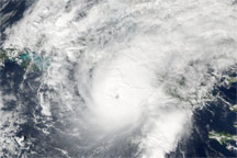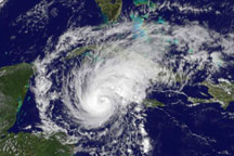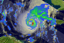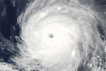
Hurricane Paloma was well-formed, with distinctive spirals and a clear eye on November 7, 2008, when the GOES satellite captured this image. The storm formed off the coast of Nicaragua on November 5, and became a hurricane the next day. When GOES captured this image, Paloma was moving steadily north-northeast at 10 kilometers per hour (6 miles per hour) on course towards Cuba. As it moved over the warm waters of the Caribbean, it strengthened. At 1:00 Eastern Standard time, about an hour before this image was taken, the storm had sustained winds near 150 km/hr (90 mph) with stronger gusts, said the National Hurricane Center. By 4:00, winds had picked up to 165 km/hr (105 mph), making Paloma a Category 2 storm. It was at this strength that the storm barreled into the Cayman Islands a short time after this image was taken.
The National Hurricane Center forecast that Paloma would continue to intensify through November 7, possibly reaching Category 3 status before weakening on November 8. The storm was forecast to come ashore over Cuba on November 8 and 9. The Cuban government has issued a hurricane warning to four provinces, said the National Hurricane Center.
NASA image created by Marit Jentoft-Nilsen, NASA GOES Project Science Office. Caption by Holli Riebeek.