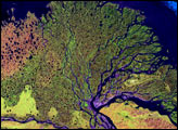
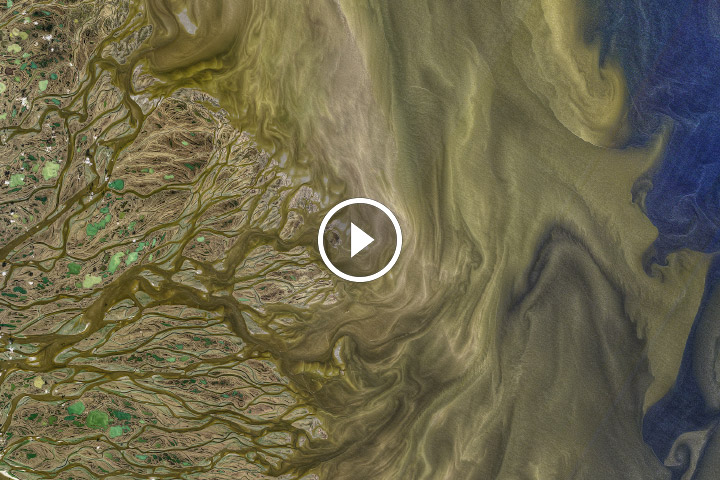
Winding 4,400 kilometers (2,800 miles) across northeastern Siberia from its headwaters in the Baikal Mountains, the Lena River is one of the longest rivers in the world. Along the way, the river and its 500 tributaries gather sediment from a drainage basin covering 2.5 million square kilometers and carry it toward the river’s massive delta.
The Lena River Delta is 400 kilometers (250 miles) wide and fans out 100 kilometers (60 miles) into the Laptev Sea. It was formed as river sediments slowly filled in small bays that were created by Arctic Ocean sea-level rise over the past 7,000 years. Each year, the river discharges nearly 550 cubic kilometers (130 cubic miles) of freshwater and more than 20 million metric tons of suspended sediment into the Laptev Sea.
Some of that suspended sediment is visible flowing from beneath an ice shelf at the top right of this image acquired June 17, 2022, by the Operational Land Imager-2 (OLI-2) on Landsat 9. Also visible are the Dunay Islands. Lying off the northwest coast of the delta in the Laptev Sea, these islands are encased in land-fast sea ice for up to nine months of the year.
Rising up to 30 meters (100 feet) above sea level and spanning more than 5,300 square kilometers (2,000 square miles), the pockmarked permafrost of the northwestern part of the delta also stands out. This older, drier part of the delta is composed of alluvial and marine sediments covered with moss and lichens, which appear lighter brown in the image. Although there are shallow valleys, none of the river channels cross this region, which is called Arga-Muora-Sissyo Island. It is covered instead by many thermokarst lakes and alasses, which formed when permafrost or buried ice melted and caused the sandy soils to subside.
NASA Earth Observatory image by Joshua Stevens, using Landsat data from the U.S. Geological Survey. Story by Sara E. Pratt.