| The Highs and Lows of the NAO | |||
For those who still don't know what those "Hs" and "Ls"
stand for on the nightly weather report, air pressure is a measure of how much
air is pushing down on the surface of the Earth at a given point. Generally,
high- and low-pressure systems form when air mass and temperature differences
between the surface of the Earth and the upper atmosphere create vertical
currents. In a low-pressure system, these vertical winds travel upwards and suck
air away from the surface of the Earth like a giant vacuum cleaner, decreasing
the air pressure above the ground or sea. This decrease in surface air pressure
in turn causes atmospheric currents moving parallel to the surface of
the Earth near the base of the low to spin counter clockwise (clockwise in the
Southern Hemisphere). Conversely, in a high-pressure
system, air is being pushed down on the ground like a vacuum put in reverse. The
downward vertical winds cause an increase in air pressure on the ground and force atmospheric currents to spin clockwise (counter clockwise in the
Southern Hemisphere). Both lows and highs function
like giant slow-moving hurricanes and anti-cyclones, respectively. The higher in
pressure a high-pressure system gets or the lower in pressure a low-pressure
system gets, the more robust and larger this spinning circulation pattern
becomes. |
|||
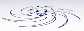 |
A low pressure system will pull in air from the surrounding area. Winds around a low spiral counter-clockwise (in the Northern Hemisphere, clockwise in the Southern Hemisphere) and upwards towards the center of the system. View animation [945kb] (Image by Robert Simmon) | ||
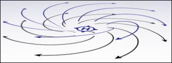 |
Air is pushed away from a high pressure system. The winds rotate clockwise (in the Northern Hemisphere, counter-clockwise in the Southern Hemisphere) and away from the system's center. View animation [910kb] (Image by Robert Simmon) | ||
“Generally speaking the NAO is an oscillation in atmospheric mass between a low around Greenland and Iceland and a high over the Azores west of Portugal,” says Vikram Mehta. He is an atmospheric scientist at NASA’s Goddard Space Flight Center who has been studying Atlantic climate anomalies for over 10 years. |
|||
He explains that a permanent low-pressure system exists over Greenland and Iceland, and a permanent high-pressure system exists over a group of islands roughly 900 miles (1400 kilometers) west of Portugal, known as the Azores. For most of the year, the high and the low are mild, and their influence on the Atlantic basin climate is minimal. When winter hits, however, all of this begins to change. Both pressure systems grow much more intense and begin to fluctuate from week to week between two different states. In one state, which scientists call a positive NAO, the high-pressure system grows especially high, while the low-pressure system grows especially low, creating a large pressure difference between the Azores and Iceland. In the other state, known as a negative NAO, the high-pressure system weakens and the low becomes shallow, creating a milder pressure difference between the two regions of the Atlantic. As the low and high intensify and relax, the winds revolving around their centers increase and decrease in both strength and in extent. During a strong positive NAO, the two pressure systems can just about cause all the currents in the northern half of the northern Atlantic to spin counterclockwise and all those currents in the southern half to spin clockwise. Though the impact of the NAO and its phases can be felt across the entire Atlantic and the surrounding continents, its greatest effect is on the storms passing into Europe. Between the two swirling, clockwise and counterclockwise circulation patterns created by the high and low, there is an area where they come together and form a steady, forward-moving current that channels weather systems from the United States to Europe. “As the pressure systems vary, they modulate the winds along this track and change the number of storms and the amount of moisture over Europe coming from the Atlantic and the Gulf Stream,” says Mehta. Like two wheels of a printing press, the high and low systems can increase or decrease the strength of the winds along this channel. When the pressure difference between the two systems is large (a positive NAO index), the winds along this conduit pick up, and they push the storms north towards Scandinavia and northern France. When the pressure difference is small (a negative NAO index), the storms take a more direct course from the southern United States to southern Europe, the Middle East, and northern Africa. Jim Hurrell is an atmospheric scientist at the National Center for Atmospheric Research who spent a number of years analyzing the connection between the North Atlantic Oscillation and winter weather. He says, “The direction these storms take as a result of NAO can cause remarkable changes in the temperature and the weather over Europe from December through March.” A positive NAO on average can increase rainfall in northern Europe by a little over an eighth of an inch per day and warm the air there by roughly 5 degrees Fahrenheit (2.8 degrees Celsius). If the condition persists for most of the winter, it can lengthen the growing season by 20 days in Sweden, lower reindeer populations in Norway, lead to water shortages in the Fertile Crescent, and provide sunnier, drier conditions for tourists on the French Riviera. A negative NAO, on the other hand, will bring rain to southern Europe, drop the temperatures in northern Europe, and maintain the already warm climate across the Mediterranean. If the negative state persists, it will increase the production of olives and grapes in Greece, put Denmark in a deep freeze, and create ideal skiing conditions in Austria. |
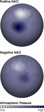 The positive and negative phases of the North Atlantic Oscillation are defined by the differences in pressure between the persistent low over Greenland and Iceland and the persistent high off the coast of Portugal. During a positive NAO, both systems are stronger than usual. That is, the low has a lower atmospheric pressure and the high has a higher atmospheric pressure. During the negative phase of the NAO, both systems are weaker, lowering the difference in pressure between them. (Images by Robert Simmon) | ||
Hurrell said the NAO’s effects could also be felt to a lesser degree in the United States. When the NAO is classically positive, the high-pressure system residing near the Azores strengthens. The winds rotating around the system expand and push warm air from the tropical Atlantic and the Caribbean northward. “So on the west side of the Azores high you have warm air being advected on to the Caribbean and up onto the East Coast, creating a warmer winter along the mid-Atlantic States,” says Hurrell. The result is typically less snowfall for the Washington-New York corridor. During a negative NAO, the high-pressure system grows weak and winter storms, and cold weather that are normally meant for Boston and Maine, head south. “As to this winter, though the NAO was slightly negative this year and has contributed to the winter weather, it does not appear to be a classic NAO pattern,” he says. He explains that the El Niño has led to a slight deepening of the low-pressure system that typically sits over the southeastern United States during the winter, which has brought colder temperatures and more precipitation to the mid-Atlantic. If the NAO was strongly positive on average, as it has been in recent years, then the warm temperatures from the Azores high would likely have counteracted these colder temperatures and the weather would have been much milder along the East Coast. But this year the NAO was neither particularly strong nor particularly weak, and the dominant low-pressure system in the Atlantic was a bit south and east of Greenland. The net effect has been the cold weather and winter storms in the northeast United States. Hurrell adds that there weren’t any pronounced impacts on the European spring or winter either and that storms have tended towards the northern and southern Europe largely without bias.
|
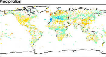
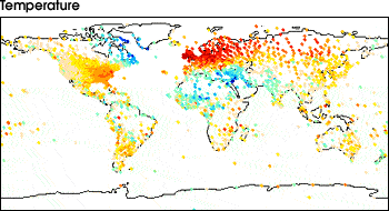
The maps at left show the relationship between a strong positive NAO and precipitation and temperature. Positive correlation means that an area is wetter or warmer than normal, negative correlation means an area is drier or colder than normal, and no correlation means the area is unaffected by the NAO. (Images courtesy Lamont-Doherty Earth Observatory) |