| The Trouble With Intensity | |||
|
Though forecasters had trouble predicting the intensity of both Paka and Opal, they were more confident in terms of predicting where the hurricanes would hit land. Over the last thirty years, forecasting the movement of hurricanes has steadily improved. The number of deaths per year from hurricanes in the United States has dropped by half over this time period despite the fact that coastal populations in the eastern U.S. have doubled.
Improvements in storm tracking have had everything to do with technology. Since the late 1960s, a number of satellite networks such as the NOAA's GOES (Geostationary Operational Environmental Satellite) and AVHRR (Advanced Very High Resolution Radiometer) have been launched into orbit for the specific purpose of monitoring weather. The primary sensors on most of these craft measure the visible and infrared light (light just beyond visible red on the color spectrum) emitted and reflected off clouds and the surface of the Earth. By analyzing these satellite data, scientists can observe such variables as sea surface temperature, atmospheric temperature, and wind speed all around a hurricane as it makes its way to shore (NESDIS Public Affairs, 1995). The other big advance has been with the computer models forecasters use to predict a hurricane's path. These models are essentially complex computer programs. Researchers feed known variables such as wind current direction collected by the satellites and reconnaissance aircraft into the models. The models then run the measurements through a series of algorithms and various other calculations and come up with the most likely predictions of hurricane trajectories. Due to ever more powerful computers and improved programming techniques, the models have become more accurate each year (National Hurricane Center Public Affairs, 1996). Despite all these new tools and resources, researchers still have difficulty predicting intensity. The problem is that to forecast intensity accurately, researchers have to understand what is going on inside and directly underneath the hurricane. Visible and infrared imaging satellites such as AVHRR cannot see past the upper cloud layer of a hurricane. The clouds block nearly all visible and infrared radiation coming from the surface of the Earth and from within the clouds, thus all the scientists receive from those sensors are images of reflective white and gray clouds. While aircraft and balloons can retrieve internal readings, they cannot do so quickly across the entire hurricane and not for a sustained period of time. Most current models that forecast intensity do so by relying on those conditions that lie sometimes days in front of the storm or by comparing these readings to a jumble of statistics on past hurricanes in the area (Henson, 1998). To get a truly accurate prediction of intensity, however, scientists need to know how warm the ocean is below the hurricane, how deep the warm water extends and, most importantly, if the heat released inside the eye wall of a hurricane is increasing. |
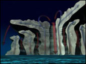
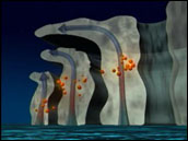
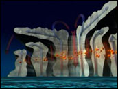 The driving engine of a hurricane converts heat from tropical ocean waters to raging winds and heavy rain. In this animation, notice how heat is drawn up by central, cyclonic winds and distributed to the swirling clouds surrounding the eye. The warmer the ocean waters beneath, the more powerful the storm is likely to grow. view animation (3.3MB)
Animations courtesy NASA Goddard Space Flight Center Scientific Visualization Studio | ||