| Everyone Complains About the Weather… |
| ||
| Betts and
his BOREAS colleagues observed that, in the spring, daily weather
forecasts significantly underestimated air temperatures over the boreal
forest, sometimes by as much as 10—15°C (18—27°F) (Viterbo and
Betts, 1999). Additionally, the BOREAS team found that predictions of
cloud cover over the boreal region were often far off the mark.
Everyone complains about the weather, but how could the forecasts be so
wrong so often? |
|||
 The scientists noticed a pattern that confirmed their earlier suspicions: the temperature forecasts were farthest off in late spring when snow was on the ground and grew more accurate after the snow melted. From summer through fall, the weather models matched actual measurements more closely (Betts et al. 1998). But the following year, come springtime, the forecasts again became increasingly inaccurate until snow melted. Why were the weather forecasts so inaccurate every spring? …BOREAS Did Something About The Forecasts
|
This map shows the average errors in the European Centre for Medium-Range Weather Forecasts at 850mb (roughly equivalent to an altitude of 1500m) for March and April of 1996. The predictions, made five days in advance, were compared to actual measurements. The 1996 model did not include the adjustments to forest albedo. (Figure from Viterbo, P. and A.K. Betts, 1999: The impact on ECMWF forecasts of changes to the albedo of the boreal forests in the presence of snow. J. Geophys. Res. (In press, BOREAS special issue). Courtesy A.K. Betts)
| ||
 How could meteorologists have made this mistake? Betts explains that
in mid-winter the models were fairly accurate because the angle of the
sun is low relative to the horizon (about 20 degrees), days are shorter,
and the amount of incoming sunlight is small. Occasionally after
snowfall, snow also remains in the canopy for a few days and reflects
more sunlight. Yet in May, when the sun angle is higher and days are
longer, there is more sunlight and no snow in the canopy to reflect it.
Consequently, the canopy in dense forest regions intercepts most of the
incoming sunlight, while the snow on the ground below is shaded. How could meteorologists have made this mistake? Betts explains that
in mid-winter the models were fairly accurate because the angle of the
sun is low relative to the horizon (about 20 degrees), days are shorter,
and the amount of incoming sunlight is small. Occasionally after
snowfall, snow also remains in the canopy for a few days and reflects
more sunlight. Yet in May, when the sun angle is higher and days are
longer, there is more sunlight and no snow in the canopy to reflect it.
Consequently, the canopy in dense forest regions intercepts most of the
incoming sunlight, while the snow on the ground below is shaded. |
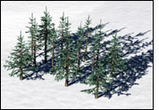
Trees in the Boreal forest shade the snow underneath them. The effect is more significant than it is in southern latitudes because the sun is so low in the sky, creating very long shadows. | ||
| "Fresh snow on grass reflects about 80 percent of the sun’s
light and absorbs 20 percent," Betts states. "The more
sunlight that is reflected back up into the atmosphere, the cooler the
surface temperatures. On the other hand, conifer trees (e.g., spruce
and pine) reflect only 10 percent of the sun’s energy and absorb
the rest, warming the surface and transferring the heat back to the
atmosphere."
Yet the global forecast models used by NCEP and ECMWF treated the boreal forests in the spring as if they were snow-covered grasslands with an albedo of 60—80 percent, instead of forests with snow under the trees with an albedo of 10-20%. The models estimated that the boreal forest absorbs 100 Watts per square meter in the daytime, while BOREAS measurements show that the forest is actually absorbing between 300—400 Watts per square meter (Betts et al., 1998). According to Betts, when the new albedo measurements made by the BOREAS team were entered into the models, there was a large improvement in the accuracy of the temperature forecasts in Spring. "Actually, this problem was known by meteorologists for some time," Betts notes. "Yet we didn’t realize the magnitude of the problem until 1996. We have been trying to update the models for several years, but it wasn’t until after the BOREAS field program of Spring, 1996 that we succeeded in inserting these new data into the global forecast models." |
| ||