
Heavy monsoon rains pounded India and Bangladesh in early July 2010. The Integrated Regional Information Networks (IRIN) reported that more than 600,000 river island residents had been marooned, and thousands of hectares of farmland had been destroyed in Bangladesh by flooding. Meanwhile, CNN reported that monsoon floods had killed at least 221 people, and affected a million more in India since June 1.
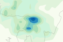
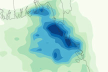
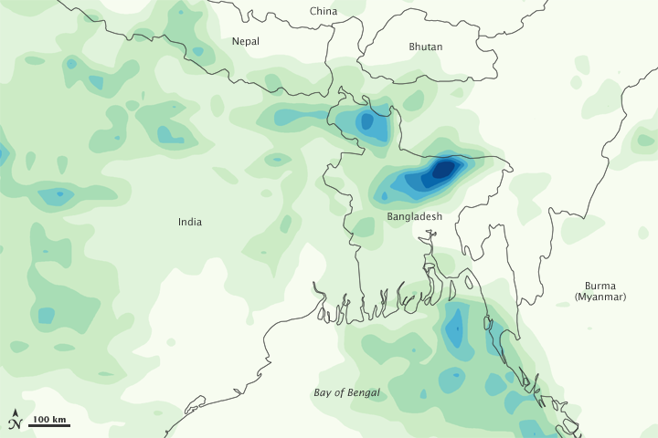
This color-coded image shows rainfall amounts in India, Bangladesh, and the Bay of Bengal from July 6 to 12, 2010. The heaviest rainfall amounts—400 millimeters or nearly 16 inches—appear in dark blue. The lightest amounts—50 millimeters or less than 2 inches—appear in light green. The heaviest rainfall amounts appear concentrated in northern and eastern Bangladesh, although substantial rainfall amounts affect a much larger area.
This image is based on data from the Multisatellite Precipitation Analysis produced at Goddard Space Flight Center, which estimates rainfall by combining measurements from many satellites and calibrating them using rainfall measurements from the Tropical Rainfall Measuring Mission (TRMM) satellite.
NASA Earth Observatory image by Jesse Allen, using near-real-time data provided courtesy of TRMM Science Data and Information System at Goddard Space Flight Center. Caption by Michon Scott.