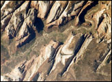
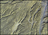
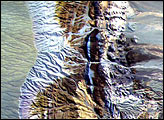
In eastern Siberia, a perfect circle of rock contrasts with the surrounding topography. The 6-kilometer- (3.7-mile-) wide ring looks like an impact crater, or the caldera of an extinct volcano, but it is neither. Kondyor Massif was formed by the intrusion of igneous, or volcanic, rock that pushed up through overlying layers of sedimentary rock, some of them laid down more than a billion years ago.
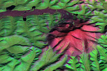
On June 10, 2006, the Advanced Spaceborne Thermal Emission and Reflection Radiometer (ASTER) on NASA’s Terra satellite observed Kondyor Massif. This three-dimensional view was made by draping ASTER image data over a ASTER-derived topography data (a digital elevation model, or DEM) to give a sense of the feature’s proportions. The circular ring of rock is bare, but vegetation otherwise prevails, both inside and outside the circle. In this image, even sparse vegetation appears bright green. Water collecting in the middle of the massif has formed a river that flows out of the massif, on the north side.
Kondyor Massif interests geologists not just because of its unusual appearance, but also because of its mineral richness. Among the highly valued minerals at this site are gold, silver, and platinum. Coarse platinum-iron crystals from this site can reach 1.5 centimeters (0.6 inches) in size, and the area has been mined for platinum.
NASA image created by Jesse Allen, using data provided courtesy of GSFC/METI/ERSDAC/JAROS, and the U.S./Japan ASTER Science Team. Caption by Michon Scott.