If a landslide occurs in a remote mountain range but nobody sees or hears it, does it matter? Unequivocally yes, says Columbia University geophysicist and landslide specialist Colin Stark. Even when they occur in remote areas, large landslides can dam rivers and lead to devastating downstream floods.“It’s especially critical that we monitor ‘catastrophic’ landslides—fast-moving slides that involve more than a million tons of debris,” Stark says. “These are the most dangerous landslides, but they often go undetected.”
Stark is working to change that. Along with colleague Göran Ekström, he has pioneered a new method to detect landslides by analyzing seismic waves—the vibrations that radiate through Earth’s crust because of sudden movements of rock, ice, magma, or debris. Stark and his colleagues used the technique to locate the landslide shown in the satellite images above.
Automated earthquake detection systems are tuned to monitor intense, “short-period” waves produced by sudden slips along tectonic faults. Landslides produce seismic waves as well, though their short-period signal is weak. Instead, they make powerful long-period waves that are sometimes detectable at great distances.
Stark and Ekström are developing a computer algorithm to scan seismographic data specifically for the long-period waves associated with landslides. They started by applying their technique to historical data. As the pair detailed in a study published in Science, their approach detected about 29 large landslides that occurred between 1980 and 2012 that did not register on standard earthquake-monitoring systems.
In July 2013, Stark and Ekström—with help from Columbia University colleague Clément Hilbert—had an opportunity to test their technique in real time. On July 25, Stark noted a possible landslide event in southeastern Alaska. His initial analysis of the seismic data suggested the slide occurred in eastern Alaska and had a mass of about 20 million metric tonnes (22 million tons). However, seismic data alone could not tell the researchers exactly where the slide had occurred, only that it happened within a 25 square-kilometer (10 square-mile) area in the Wrangell Mountains.
That’s where satellites proved critical. When Stark informed the NASA Earth Observatory about the possibility of a slide, EO staff checked the imagery acquired by the Operational Land Imager (OLI) on NASA’s Landsat 8 satellite. Within a few days, they located the slide.
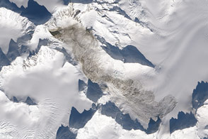
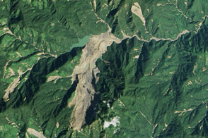
The landslide occurred in Wrangell-St. Elias National Park at 61.978° North latitude and 143.168° West longitude. Since the landslide is difficult to make out in the true-color OLI image below, the location has been highlighted in yellow. Click on the image to see how the landslide looks without yellow highlighting.
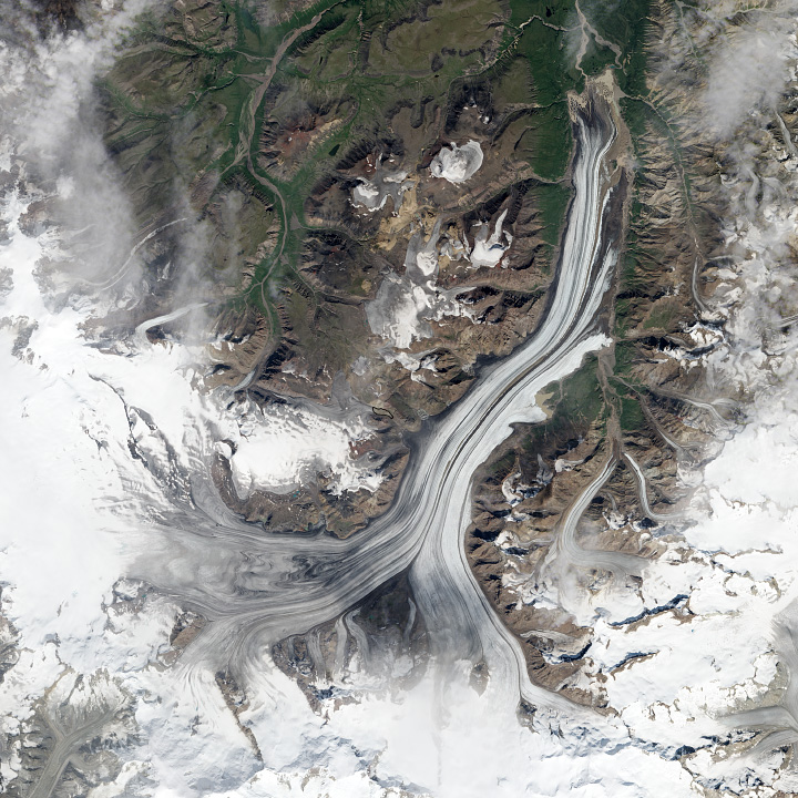
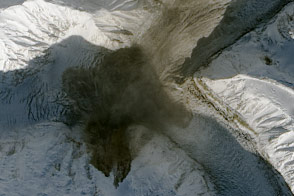
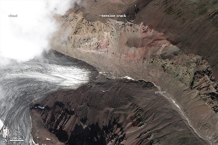
With the location pinned down, Stark requested the acquisition of the higher-resolution images shown at the top of this page. New images were acquired by one of the Pleiades satellites managed by France’s Centre National d’Etudes Spatiales (CNES). The upper image shows the end of a small glacier, east of Mount Jarvis, on July 24, 2013, about 13 hours before the landslide. Note the tension cracks on the south-facing side of the valley wall—a sign the slope was on the verge of collapse.
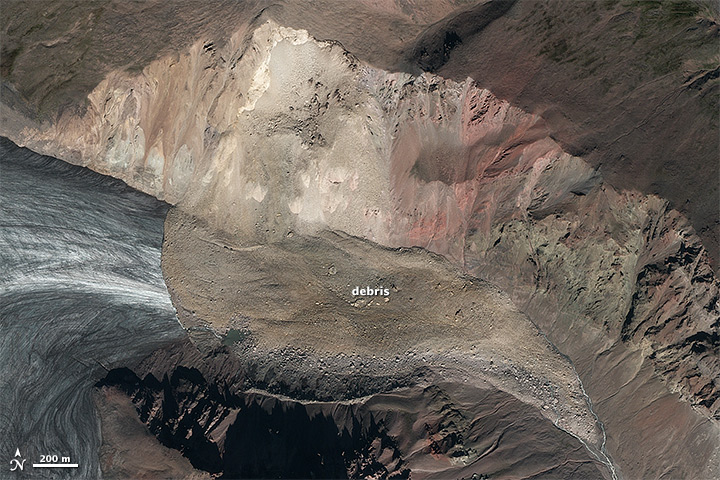
The second image shows the same area after the landslide on August 13, 2013. Debris had tumbled down the valley wall, blanketed the end of the glacier, deflected off the far wall of the valley, and tumbled down the valley toward Nabesna Glacier to the southeast. A stream of glacial melt water was pooling; it should eventually carve a new channel through the debris.
What triggered the slope to fail? Stark suspects that an unusual summer heat wave in southern Alaska in summer 2013 played a role. “Most of the big landslides that I've worked on in Alaska from 1999 to now have been south-facing, summer-time failures,” he says. “My suspicion is that this landslide was probably caused by sustained daytime warming and progressive melting of rock permafrost.”
Pleaides satellite images are copyright Astrium. Images created by Jesse Allen and Robert Simmon, using Pleaides data provided courtesy of Colin Stark (Columbia University) and Landsat 8 data provided by the the U.S. Geological Survey. Stark’s research is supported by the National Science Foundation. Caption by Adam Voiland.