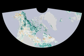
Scientists using the twin gravity-measuring satellites of the Gravity Recovery and Climate Experiment (GRACE) have found that a large portion of the Middle East lost freshwater reserves rapidly during the past decade. The research team observed the Tigris and Euphrates river basins—including parts of Turkey, Syria, Iraq, and Iran—and found that 117 million acre feet (144 cubic kilometers) of fresh water was lost from 2003 to 2009. That amount is roughly equivalent to the volume of the Dead Sea. About 60 percent of the loss was attributed to the pumping of groundwater from underground reservoirs.
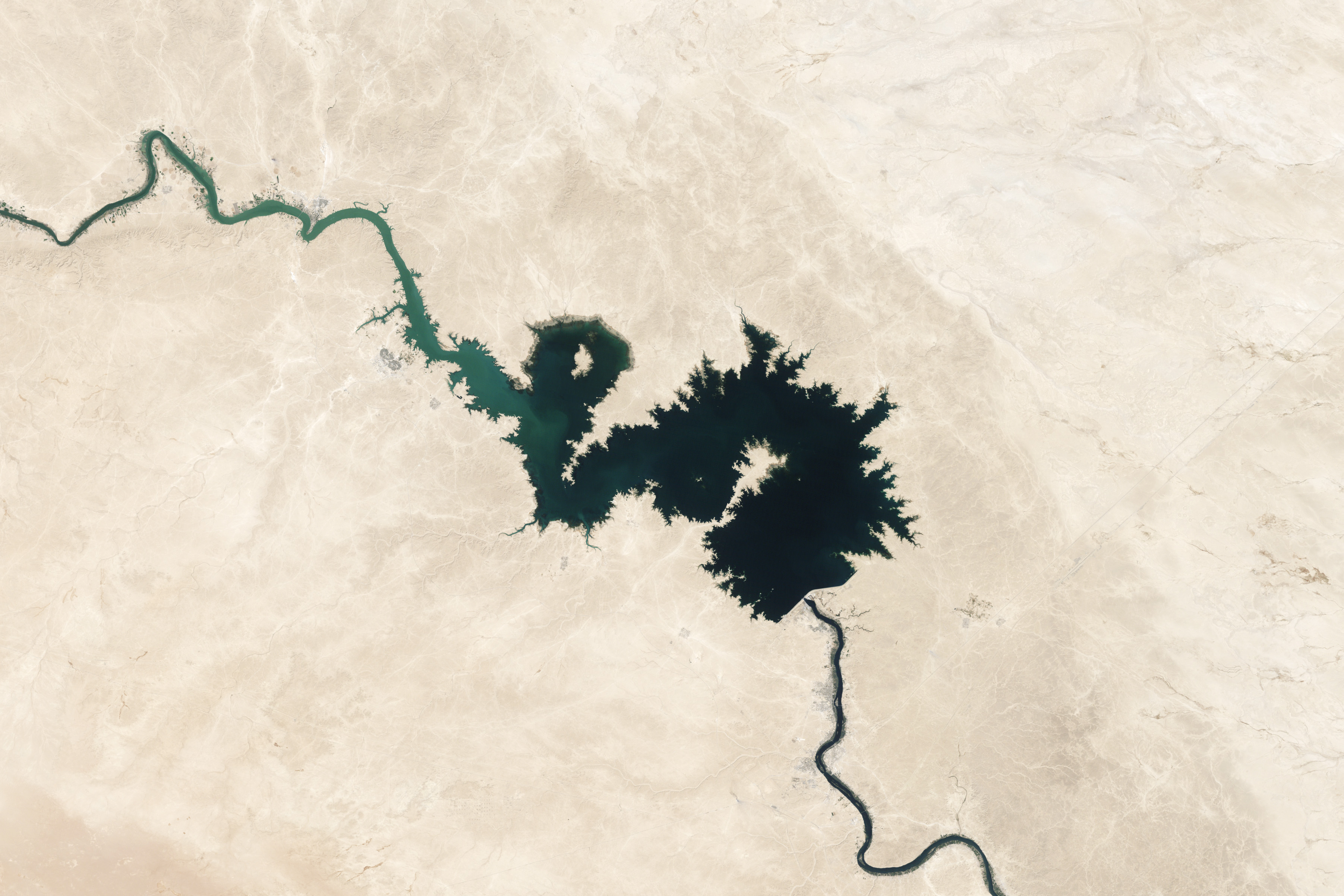
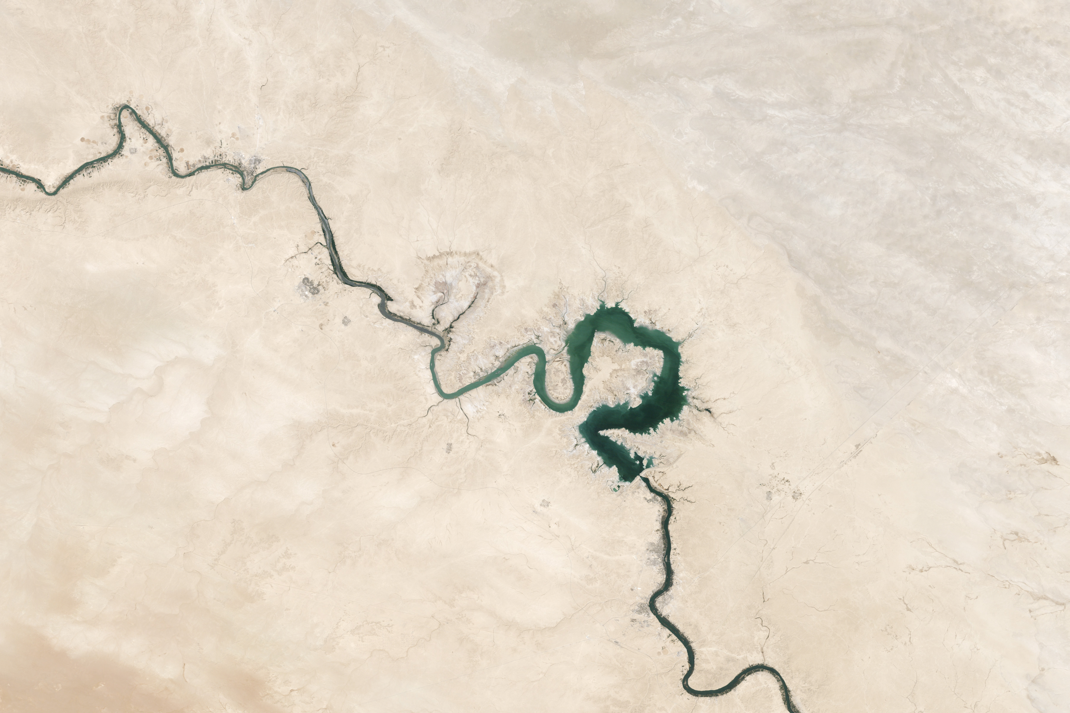
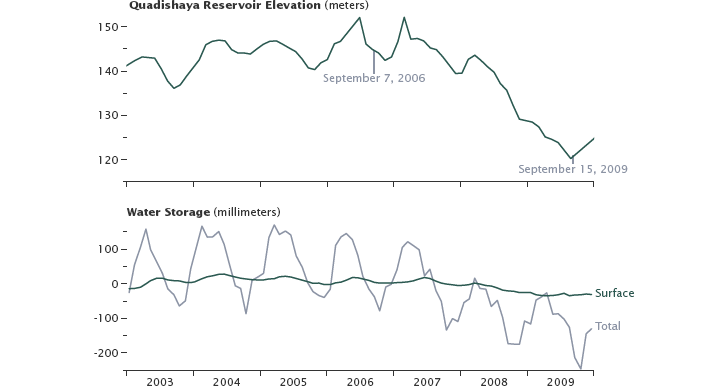
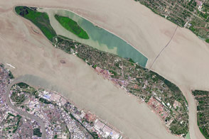
The two natural-color images above were acquired by the Landsat 5 satellite and show the shrinking of the Qadisiyah Reservoir in Iraq between September 7, 2006 and September 15, 2009. The first graph shows the elevation of the water in that reservoir between January 2003 and December 2009. The elevation is a proxy measurement for the total volume of water stored there; labels show the water elevation at the time of the satellite images.
The second graph shows the water storage for the entire study area as measured by GRACE from January 2003 to December 2009. The gray line depicts total water storage in the region—groundwater, surface water bodies, and soil moisture—while the green line depicts changes in surface water. The difference between those two lines reflects the change in water stored in underground aquifers (ground water). The total water storage shows a seasonal fluctuation, but also an overall downward trend, suggesting that groundwater is being pumped and used faster than natural processes can replenish it.
“GRACE data show an alarming rate of decrease in total water storage in the Tigris and Euphrates river basins, which currently have the second fastest rate of groundwater storage loss on Earth, after India,” said Jay Famiglietti, principal investigator of the study. “The rate was especially striking after the 2007 drought. Meanwhile, demand for freshwater continues to rise, and the region does not coordinate its water management because of different interpretations of international laws.”
Obtaining ground-based data in Middle East can be difficult, so data from satellites such as GRACE are essential to providing a global picture of water storage trends. Within any given region on Earth, rising or falling water reserves alter the planet’s mass, influencing the gravity field of the area. By periodically measuring gravity in each region, the GRACE satellites tells us how water storage changes over time. (To learn more about GRACE’s ability to study fresh water on Earth, read The Gravity of Water.)
The researchers calculated that about one-fifth of the water losses in their Tigris-Euphrates study region came from snowpack shrinking and soil drying up, partly in response to a 2007 drought. Loss of surface water from lakes and reservoirs accounted for another fifth of the losses. The majority of the loss—approximately 73 million acre feet (90 cubic kilometers)—was due to reductions in groundwater. “That's enough water to meet the needs of tens of millions to more than a hundred million people in the region each year, depending on regional water-use standards and availability,” Famiglietti said.
The team was led by Famiglietti and Kate Voss of the University of California–Irvine (UCI) and Georgetown University, and included other researchers from NASA’s Goddard Space Flight Center and the National Center for Atmospheric Research.
NASA images by Robert Simmon, using Landsat data. Graphs based on data from the UC Center for Hydrologic Modeling. Caption by Mike Carlowicz based on texts from the Jet Propulsion Laboratory, American Geophysical Union, and the University of California–Irvine.


