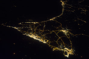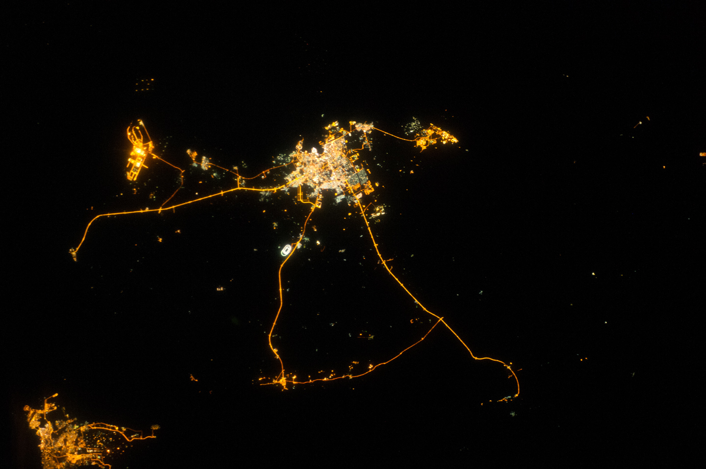
Night lights can reveal a lot about the distribution of people on the landscape, or “human geography.” In this astronaut photograph from the International Space Station (ISS), the lights of Qatar show informative demographic detail that is very difficult to discern in daylight images—especially in deserts, where even large cities can be hard to see.
The brightest group of lights at image center is the capital city, Doha, with the neighboring smaller ports of Ad-Dahira and Umm Sa’id to the north and south. (Note that north is to the left, due to the path of the ISS orbit.) Highways are clearly visible leading west from the capital to the Dukhan oil fields, to Saudi Arabia, and to the north of the country where—judging by the lack of night lights—the population is probably very low. The relatively minor coast road between the oil fields and the Saudi frontier also stands out.
Almost the entire island nation of Bahrain appears at lower left, with the capital city of Manama nearly as bright as the lights of Doha. The difference in light intensity reflects a difference in population; Doha has 1.45 million inhabitants, while the dense Manama metro area has a population of 1.2 million.
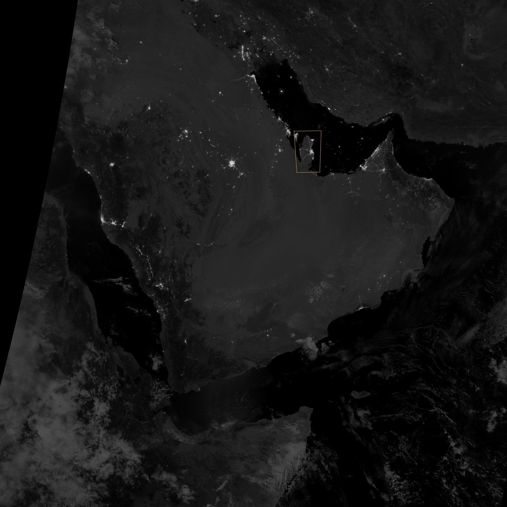
While some night views are informative about a landscape, they can also be difficult and confusing to locate. Astronauts learn to recognize where they are at night by flying over populated places repeatedly. Coastlines—one of their best geographic indicators—are generally lost to view because water surfaces and unpopulated land surfaces look the same without illumination such the full moon.
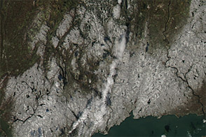
Thus, the thumb-shaped Qatari peninsula, so well-known in Middle Eastern geography, does not show up at all in this nighttime photograph. However, the low-light imaging bands of the Visible Infrared Imaging Radiometer Suite on the Suomi NPP satellite showed the Qatari peninsula and the long arm of the Gulf of Bahrain (lower image) on a moonlit night. The image was acquired during the early morning hours of September 30, 2012, two weeks before the astronaut photograph.
A detailed, daylight view of Doha is available here.
Astronaut photograph ISS033-E-14856 was acquired on October 13, 2012, with a Nikon D3S digital camera using a 70 millimeter lens, and is provided by the ISS Crew Earth Observations experiment and Image Science & Analysis Laboratory, Johnson Space Center. The image was taken by the Expedition 33 crew. It has been cropped and enhanced to improve contrast, and lens artifacts have been removed. The International Space Station Program supports the laboratory as part of the ISS National Lab to help astronauts take pictures of Earth that will be of the greatest value to scientists and the public, and to make those images freely available on the Internet. Additional images taken by astronauts and cosmonauts can be viewed at the NASA/JSC Gateway to Astronaut Photography of Earth.
Moonlit image by Jesse Allen and Robert Simmon, using VIIRS Day-Night Band data provided by the Cooperative Institute for Meteorological Satellite Studies (CIMSS) at the University of Wisconsin. VIIRS is an instrument on the Suomi NPP satellite, a partnership between NASA, the National Oceanic and Atmospheric Administration, and the Department of Defense.
Caption by M. Justin Wilkinson, Jacobs/ESCG at NASA-JSC.