For the fourth consecutive year, NASA research aircraft are flying over the Arctic to assess the health of the ice in the fast-changing region. Global warming has had a particularly strong impact on the Arctic, yet the effects on the region’s ice have been anything but steady or predictable. Some glaciers are spitting out icebergs and draining the Greenland ice sheet at an alarming pace; others are barely moving; a few are growing thicker.
The flights are part of a six-year mission called IceBridge. The airborne campaign allows scientists to keep an eye on the complex dynamics of the ice, helping them project how much melting ice sheets might elevate sea level and how fast sea ice is likely to retreat. Funded and structured like a satellite mission, IceBridge continues measurements started by the Ice, Cloud, and Land Elevation Satellite (ICESat) in 2003. ICESat stopped collecting data in 2009, making IceBridge critical for ensuring a continuous series of observations until ICESat-2 launches in 2016. IceBridge flights also collect data useful for climate modeling that ICESat could not, including measures of the land topography beneath the ice, grounding line position, and ice and snow thickness.
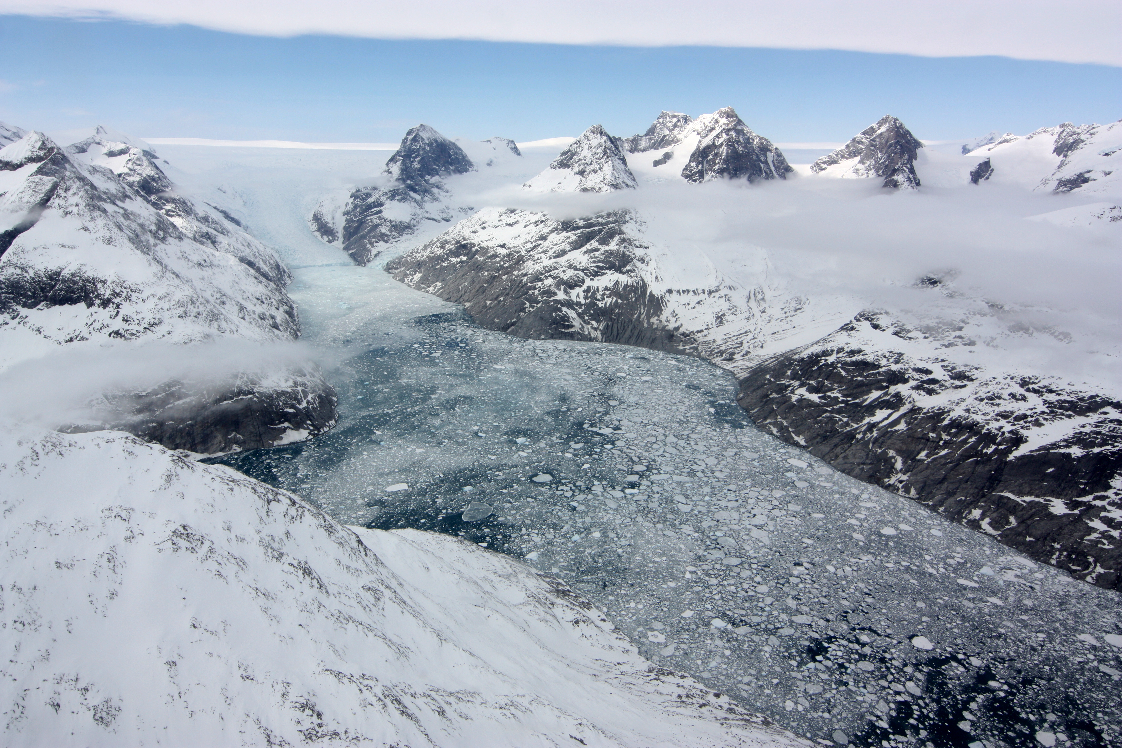
The top image, captured during an IceBridge flight, shows a glacier in southern Greenland flowing through a long and narrow valley—a fjord—carved by the movement of ice. Where the edge of the glacier meets the sea, there’s a layer of floating ice dimpled with chunks of icebergs that have broken off from the glacier. Understanding ice mélanges, as these conglomerations are called, is important because there is evidence that they can slow the rate that glaciers like this slip into the sea. The photograph was taken with a camera aboard NASA’s P-3B aircraft on April 25, 2012.
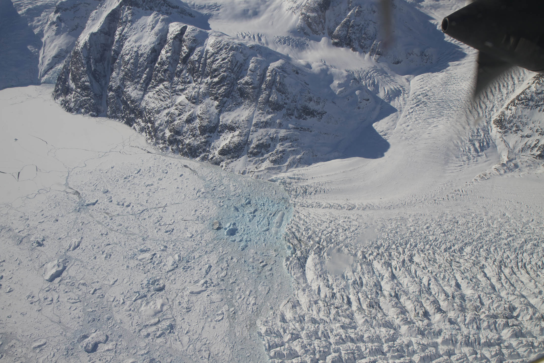
The image below shows a closer view of a different ice mélange; the noticeable patch of blue ice could have formed for a number of reasons. One possibility is that it's the result of a recent calving event. Ice breaking off the edge of the glacier could have thinned that part of the mélange causing it to be more transparent to the water below. Another possibility is that the patch of blue ice is older than the surrounding ice. Fresh glacial ice is usually white, while older ice often has a tinge of blue. That's because fresh ice has more and larger air bubbles that reflect all wavelengths of light equally. Older ice gets compressed and has fewer, smaller air pockets that cause the ice to primarily reflect blue light, which is what we see. This photograph, also captured during a P-3B flight, was taken on April 14.
This year’s Arctic campaign stands out for completing several more sea ice flights than in previous years and for covering a greater distance. Another highlight: the IceBridge team recently flew a set of coordinated flights with European Space Agency aircraft in order to verify ice thickness measurements made by CryoSat-2.
Throughout the campaign, scientists in the field have been sending back dispatches via the mission’s blog. “The once seemingly insignificant and remote Arctic region is now understood to be intimately connected to the rest of the planet,” noted Goddard Space Flight Center’s Nathan Kurtz in a post published on March 27. “Sea ice variability affecting the severity of snow storms in Europe, melting sea ice increasing the absorption of sunlight by the Earth, and melting ice sheets causing sea level rise are but a few of many such connections.“
NASA images from the IceBridge Science Team and taken by Jefferson Beck and Maria-José Viñas. Image interpretation by Bob Bindschadler, Tom Neumann, and Sophie Nowicki. Caption by Adam Voiland with reporting from George Hale and Holli Riebeek.