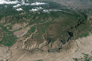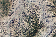
Black Canyon of the Gunnison National Park is a small park that encompasses the steep-walled canyons of the Gunnison River, which drains snowmelt from the Rocky Mountains in western Colorado. Although the elevation of canyon top is roughly level from the park’s eastern to western ends, the river drops about 300 meters (984 feet) from one end of the park to the other. The gradient is about 95 feet per mile, making it one of the steepest river descents in North America. Upstream—to the east—lies the Curecanti National Recreational Area, whose reservoirs (visible in the large-version image) have transformed the character of the Gunnison River. Where the river once had a seasonal cycle in which it flowed as a raging torrent in late spring and retreated to a gentle trickle by late summer, now it has a steady, year-round flow.
This natural-color image centers on the Black Canyon of the Gunnison River, which snakes diagonally across the scene from lower right to upper left. The canyon depths appear charcoal-colored, while the canyon rim landscape appears to have some forest cover (green). Roughly 600 meters (1,968 feet) below the rim of the Black Canyon lies the dark blue waters of the Gunnison River. To the northeast of the park, numerous streams and feeder canyons appear to flow toward the larger chasm. In the west, the white and yellow-toned rock is exposed Dakota sandstone. A grid of lush green fields is interleaved with the bright rock. This image was made from data collected by the Enhanced Thematic Mapper Plus sensor on the Landsat 7 satellite on September 12, 2000. The imagery uses data from red, green, and blue wavelengths (ETM+ bands 3, 2, & 1).
Among the interesting geologic features of the Black Canyon is that a number of apparent “feeder canyons” actually stop and run dry, or in some cases slope in the wrong direction for water to flow into the canyon. Geologists believe that after eroding the landscape for 10-15 million years, the west-flowing Gunnison River finally carved the Black Canyon all the way down into very hard, Precambrian Era rocks, about 2 million years ago. (These rocks are often called “basement” rocks because they are usually buried deep beneath the Earth’s surface). The rock is so hard that once the river carved the canyon into it, the Gunnison could no longer change course. Other, less-entrenched streams in the region have shifted to a more north-flowing drainage pattern in response to a change in the tilt of the surrounding terrain. The west-flowing Gunnison, however, is essentially trapped in the hard, Precambrian rock of the Black Canyon.
NASA image created by Jesse Allen, Earth Observatory, using data obtained courtesy of the University of Maryland’s Global Land Cover Facility.