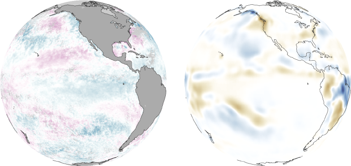

Perhaps nowhere is the intricate relationship between the ocean and the atmosphere more evident than in the eastern Pacific. The ocean’s surface cools and warms cyclically in response to the strength of the trade winds. In turn, the changing ocean alters rainfall patterns. This series of images shows the dance between ocean and atmosphere. Changes in rainfall, right, echo changes in sea surface temperature, left. Many people recognize the extreme ends of the spectrum, El Niño and La Niña, by the severe droughts and intense rains each brings to different parts of the world.
El Niño occurs when warm water builds up along the equator in the eastern Pacific. The warm ocean surface warms the atmosphere, which allows moisture-rich air to rise and develop into rainstorms. The clearest example of El Niño in this series of images is 1997. The unusually warm waters are dark purple in the sea surface temperature anomaly image, indicating that waters were as much as 6 degrees Celsius warmer than average.
The corresponding streak of dark blue in the rainfall anomaly image reveals that as much as 12 millimeters more rain than average fell over the warmed eastern Pacific. The unusual rainfall extended into northwestern South America (Ecuador and Peru). The disruption in the atmosphere impacts rainfall throughout the world. In the United States, the strongest change in rainfall is in the southeast, the region closest to the pool of warm Pacific water. During El Niño years, such as 1997, the southeast receives more rain than average.
La Niña is the build up of cool waters in the equatorial eastern Pacific, such as occurred in 1988 and, to a slightly lesser degree, 1998. La Niña’s impacts are opposite those of El Niño. The atmosphere cools in response to the cold ocean surface, and less water evaporates. The cooler, dry air is dense. It doesn’t rise or form storms. As a result, less rain falls over the eastern Pacific. Ecuador, Peru, and the southeastern United States are correspondingly dry.
El Niño and La Niña reflect the two end points of an oscillation in the Pacific Ocean. The cycle is not fully understood, but the times series illustrates that the cycle swings back and forth every 3-7 years. Often, El Niño is followed immediately by La Niña, as if the warm water is sloshing back and forth across the Pacific. The development of El Niño events is linked to the trade winds. El Niño occurs when the trade winds are weaker than normal, and La Niña occurs when they are stronger than normal. Both cycles typically peak in December.
El Niño and La Niña aren’t the only cycles evident in this image series. The Pacific Ocean is moody: It turns slightly hot or slightly cold every couple of years. This bi-annual pattern isn’t the distinctive, well-defined stripe of warm ocean waters near the equator typical of El Niño, but rather, a general warming of the ocean.
On top of the two-year warm/cold cycle and the El Niño/La Niña pattern is a broader decadal cycle in which the Pacific has a warm and a cool phase. In the 1990s, the Pacific was in a warm phase. The strong El Niño of 1997 marked the end of the warm phase. Since 1997, the Pacific has been in a generally cool phase, during which time strong El Niño events have not been able to form.
The sea surface temperature anomaly images were made from data collected by the Advanced Very High Resolution Radiometer between 1985 and 2008. They show the average sea surface temperature for the month of December compared to a long-term average of surface temperatures observed between 1985 and 2008. The rainfall anomaly images are from the Global Precipitation Climatology Project, which blends rainfall data from a number of satellites. The images compare December rainfall with the average December rainfall observed between 1979 and 2008.
