 | |||
|
February 7, 2000 In today’s information age, one can find a map for just about any occasion. There are countless maps displaying every street in North America, maps detailing the topography of every patch of land in Europe, maps outlining the types of forests in Canada, and maps showing all of India’s major mineral deposits. Maps have even been created that accurately display everything from ski resorts to scenic drives in North America. Given the overwhelming number of maps out there, one would expect that geologists, those whose job it is to understand the Earth’s make-up, would have long ago created a complete and accurate global map showing faults, volcanoes, earthquake epicenters and mountain formations known to have occurred over the recent geological past of one million years. After all, these are the phenomena that shape our planet’s surface and are responsible for many of our worst natural disasters. |
| ||
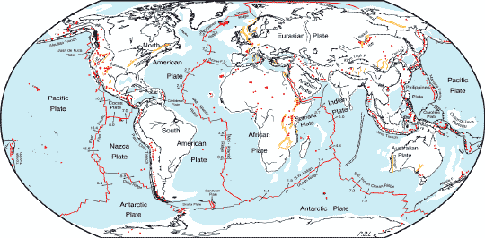 | |||
Yet, such a complete map has never been published. Most global maps of tectonic activity reflect a somewhat oversimplified view of plate tectonics. They merely show the jagged outlines of the enormous plates that make up the crust of the Earth and the faults at the boundaries of the continents. Few include active faults that lie in the middle of the plates. A number of the maps out there are even based on older, incomplete research and display ocean rifts and plate boundaries incorrectly. As a consequence, neither scientists nor students of geology have had a comprehensive, realistic, view of global tectonic activity. This cartographic gap may soon be filled. Using modern global databases, hundreds of research reports, satellite photos, and computerized drafting methods, a group of researchers at NASA’s Goddard Space Flight Center has pieced together what’s considered a series of objective and comprehensive maps (actually what’s known as a Geological Information System, or GIS) of the planet’s tectonic activity. The map shows crustal features such as faults and volcanoes that have been active within the last one million years. This period was chosen as being long enough to be truly representative of the Earth’s geologic activity, but short enough that geologic features have not been destroyed by erosion and can still be recognized. The maps show not only plate boundaries and large fault zones, but the location of major volcanic eruptions, earthquake epicenters, and movement of the Earth’s crust. The Goddard team has put all this information on the Internet for educators, researchers, and students to use. They hope the map will not only provide working scientists with an important visualization tool, but will also give future geologists the information they need to fill in the gaps of the current theories of global tectonics. | The schematic Global Tectonic Activity Map. It shows several types of faults, active spreading centers, and volcanoes. The geologists who prepared it achieved unprecedented completeness by using both historical data and satellite imagery. | ||
