|
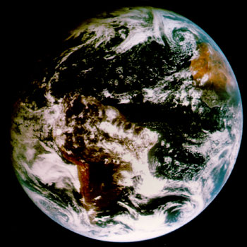
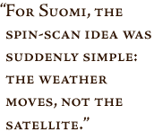
Recognizing his talents, the National Science Foundation lured Suomi away in 1962 to serve as associate program director for their Atmospheric Sciences division. In 1964, Suomi migrated to the U.S. Weather Bureau where he served as chief scientist for one year. Then, in 1965, Suomi and Robert Parent, a professor in electrical engineering, started the Space Science and Engineering Center (SSEC) at UW-Madison with funding from NASA and the National Science Foundation. SSEC was to become a hotbed of invention and research, and it was where Suomi’s most important and lasting invention, the spin-scan camera, was born. As early as 1963 Suomi had understood the benefits that could be gained by observing a single weather phenomenon at frequent intervals. But these kinds of observations just weren’t possible using the existing, low polar-orbiting satellites. Then he read about NASA’s new geostationary Advanced Technology Satellite (ATS); 22,000 miles out in space, this satellite would move in an orbit above the equator at the same speed as the Earth spins. For Suomi the spin-scan idea was suddenly simple: “the weather moves, not the satellite.” This “gadget,” as Suomi affectionately called all his inventions, allowed scientists to observe weather systems as they developed instead of glimpsing small bits at odd intervals. Satellite sensing technology was suddenly transformed from the production of interesting snapshots into the gathering of meaningful, quantitative data. It is no exaggeration to say that this invention revolutionized satellite meteorology. The weather satellite images that the public around the world sees on the evening news and relies on to protect them from natural disasters are a direct result of Suomi’s invention. Suomi and Parent saw their spin-scan camera launched on ATS-1 in 1966. Mounted aboard the spin-stabilized satellite, the camera scanned a small strip of the Earth with each rotation. By tilting the camera slightly for the next rotation, an image of Earth could be created in less than 30 minutes. Now it was possible to measure and track air motion, cloud heights, rainfall, even pollution and natural disasters. This technology soon became an operational necessity. It helped to improve the accuracy of forecasting and has saved many thousands of lives over the years. While the original spin-scan design is no longer in use in the United States, Suomi’s basic concept has been adopted for many satellites and space probes. These were built for NASA and the National Oceanic and Atmospheric Administration (NOAA), as well as the European Space Agency (ESA), and the Japanese Meteorological Agency.
By 1967, the spin-scan pictures were in color and by 1971 work had begun on an instrument that would profile the atmosphere’s temperature and water vapor from geostationary satellites. The Visible-Infrared Spin-Scan Radiometric Atmospheric Sounder (VAS) was a modification of the original spin-scan design with additional detectors for the proper spectral bands. By observing temperature and moisture structures, Suomi hoped to improve the prediction of severe weather. When the VAS was finally launched in 1980 aboard the Geostationary Operational Environmental Satellite-4 (GOES-4) satellite, it performed with the accuracy Suomi had predicted in his original 1971 proposal. The geostationary sounder remains the only instrument able to observe severe storms over regions of hundreds of thousands of square miles. Suomi’s work proved both the need for sounders and their feasibility. This technology is continued today with the GOES-8, -9, and -10 sounder instruments. With the advent of these new tools, the flow of meteorological data quickly became an overwhelming flood. Experiments conducted under the Global Atmospheric Research Program (GARP) added to the already vast amount of data. To make sense of all this, or as he put it, to try “to get a drink from the fire hydrant,” Suomi became the driving force behind the development of a computer system that could gather and handle the vast amount of imagery and data. next: McIDAS
|
 On the Shoulders of Giants
Related Sites
| ||