|
Abstract Art or Arbiters of Energy?
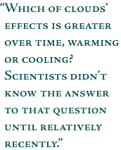
More than just the idle stuff of daydreams, clouds help control the flow of radiant energy around our world. Clouds are plentiful and widespread throughout Earth’s atmosphere—covering up to 75 percent of our planet at any given time—so they play a dominant role in determining how much sunlight reaches the surface, how much sunlight is reflected back into space, how and where warmth is spread around the globe, and how much heat escapes from the surface and atmosphere back into space. Clouds are also highly variable. Clouds’ myriad variations through time and space make them one of the greatest areas of uncertainty in scientists’ understanding and predictions of climate change. In short, they play a central role in our world’s climate system. Whereas thick, low-level stratocumulus clouds cool the Earth’s surface by reflecting incoming solar radiation, thin high-level cirrus clouds exert a warming influence by allowing sunlight to pass through but then trapping the heat emitted by the surface. Which of clouds’ effects is greater over time, warming or cooling? Scientists didn’t know the answer to that question until relatively recently. Based upon ERBE satellite data collected in the 1980s, coupled with aircraft and surface-based measurements, scientists demonstrated that, globally, clouds’ cooling effect on the surface is greater than their warming effect. So great is this cooling effect, it is as if clouds remove the heat of a 60-watt light bulb from every 2-by-2-square meter of the Earth’s surface. But will they continue to cool our planet over the next century if a greenhouse gas-driven global warming scenario comes to pass? Or even, could the type and distribution of clouds change so that they primarily exert a warming influence?
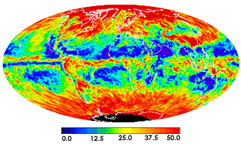
The MODIS sensor, aboard NASA’s Terra satellite, measures cloud optical thickness over the entire globe every day. Basically, cloud optical thickness is a measure of how much sunlight is prevented from traveling down through a column of atmosphere by clouds. This image shows a composite for April 2001. Reds indicate high values while blues and purples show where the air is relatively clear; no data are available for the region colored black.
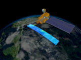
Two new sensors flying aboard NASA’s Terra satellite, launched in December 1999, are designed to help scientists answer these questions. The Moderate-resolution Imaging Spectroradiometer (MODIS) and the Multi-angle Imaging Spectroradiometer (MISR) give scientists new capabilities for measuring the structure and composition of clouds. MODIS observes the entire Earth almost every day in 36 spectral bands ranging from visible to thermal infrared wave-lengths. With spectral and spatial resolutions superior to that of AVHRR (its heritage sensor), MODIS can measure a wide suite of clouds' physical and radiative properties. Specifically, MODIS can determine whether a cloud is composed of ice or water particles (or some combination of the two), it can measure the effective radius of the particles within a cloud, it can observe how much (or little) sunlight passes through a cloud, and it can measure the temperature and altitude of cloud tops. Moreover, with its unique 1.37-micron channel, MODIS observes thin cirrus clouds with unprecedented sensitivity. This channel not only enables scientists to quantify the impact of cirrus clouds on the radiation balance, but it also permits image analysts to “correct” for the presence of cirrus in remote-sensing scenes used to examine surface or lower-level features.
Complementing MODIS, the MISR instrument “sees” the Earth simultaneously in red, green, blue, and near infrared wavelengths at nine different angles—at four progressively more oblique angles ahead of Terra, four angles aft of the satellite, and one at nadir. Because it measures any given scene from multiple angles, MISR is ideally designed to help scientists better understand how clouds interact with radiant energy as both a function of their structure and type. CERES complements MODIS and MISR by providing measurements of the shortwave and longwave radiant energy that clouds reflect and emit back into space.
ESA’s next-generation satellite missions for comprehensively examining Earth’s climate system will begin with the late 2002 launch of its first Environmental Satellite (Envisat). Similar to MODIS in the scope of its research applications, Envisat carries the Medium-Resolution Imaging Spectrometer (MERIS). Like Terra’s MODIS, MERIS has a wide viewing swath (1,500 km), with a morning equatorial crossing, and it can see the entire Earth within every 3 days. Scientists are using its data to derive cloud cover, cloud altitude, water vapor, and aerosol properties. Unlike MODIS (which uses a cross-track scan mirror), MERIS is a push-broom scanner based upon Charge-Coupled Device (CCD) technologies with gains and offset settings that can be optimized for observing specific targets. This is a similar technology to that used by MISR.
next: Serendipity and Stratospheric Ozone
back: Dust in the Wind |
|
The MODIS instrument, aboard NASA’s Terra satellite, is sensitive to 36 different wavelengths ranging from the visible to the thermal infrared region of the spectrum. With its 2,330-km-wide swath, MODIS “sees” the entire Earth almost every day, making it an ideal sensor for observing and measuring global-scale dynamics. (Animation courtesy Reto Stockli) Click here for an animation (will open in a new window).
Remote Sensing
Introduction
Balancing Earth’s Radiant Energy Budget
Dust in the Wind
Abstract Art or Arbiters of Energy?
Serendipity and Stratospheric Ozone
The Chemistry of Earth’s Atmosphere
Where Storm Clouds Gather
Conclusion
Related Articles
Aerosols and Climate Change
Clouds and Radiation
Why isn’t Earth Hot as an Oven?
Related Datasets
TOMS Ozone
Precipitation
Cloud Fraction
|
