A Battle with Bergs |
|||
The icebergs moving around McMurdo Sound in the summer of 2004 and 2005 had spent the previous four years anchored fast near Ross Island, but by December 2004, two had swung free and were moving through the very waters Stone was trying to get supplies through. He might be able to plot a course around the icebergs, but what would he do if one of the icebergs moved into the shipping channel or trapped the supply ships? It was as if Stone were a highway planner trying to devise a detour around a pothole larger than the state of Rhode Island that moved unpredictably across the road. And the “pothole” had three smaller companions whose sizes were still best measured in kilometers. The largest of the quartet was the B-15A iceberg, which measured 122 kilometers long by 28 kilometers wide in late 2004. The second iceberg, C-16, was only a quarter of the size of B-15, but was still 48 kilometers long by 18.5 kilometers wide. The other two bergs, B-15J and B15-K, had broken from B-15A and measured 56 by 41 kilometers and 59 by 9 kilometers, respectively. In November 2004, B-15A had started to drift away from Ross Island and blockaded McMurdo Sound, freeing the way for B-15J to move. Its timing couldn’t have been worse. Supply ships were scheduled to arrive in Antarctica at the end of December and early January, and the fast-moving B-15A iceberg was blocking the northern section of the traditional shipping route. Meanwhile, the still stationary B-15K iceberg blocked the southern portion of the route. |
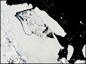
Icebergs blocked McMurdo in late 2004 and early 2005. MODIS acquired this image of B-15 in February 2005. |
||
“We were really, really worried at how we were going to supply McMurdo Sound,” confides Stone, deep concern evident in his voice even months after the end of the season. To get the ships safely to McMurdo Station, Stone needed to know where the icebergs were going on a regular basis. When the bergs started to move, he turned to MODIS, a sensor on NASA’s Terra and Aqua satellites that collects daily imagery of the entire Earth. |
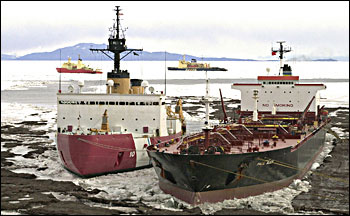
U.S. Coast Guard icebreaker Polar Star (left) and U.S. Navy tanker USNS Paul Buck broke ice near McMurdo in February 2005. (Photo courtesy National Science Foundation) |
||
