 |
by Laurie J. Schmidt |
||
|
Many processes that shape the Earth's landscape happen too slowly to be witnessed in a human lifetime. But recent analysis of satellite imagery shows that a large glacier tongue on the coast of East Antarctica has disintegrated, changing the shape of the coastline almost overnight.
|
|
||
|
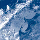
Rob Massom, polar research scientist at the Antarctic Cooperative Research Centre at the University of Tasmania, Australia, discovered the recent breakout of the entire Ninnis Glacier Tongue purely by chance. "I was looking at sea ice distribution and noticed something unusual in the satellite images," said Massom. "The coastline looked very different than it had in previous images."
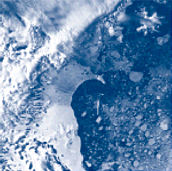
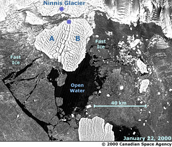
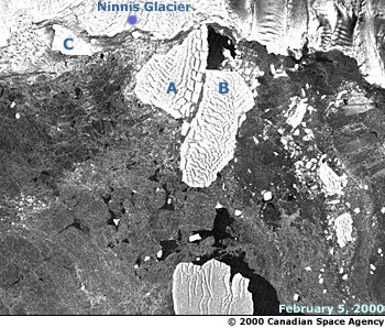
The Ninnis is one of two prominent floating glacier tongues that extend into the Southern Ocean from the coast of King George V Land. Situated along the eastern coast of the Antarctic Ice Sheet south of Tasmania, the King George V Land coast is characterized by embayments and large floating ice sheets that jut out from the coast, including the Ninnis and Mertz Glacier Tongues. An ice sheet is a dome-shaped mass of glacier ice with an area greater than 50,000 square kilometers (19,300 square miles). Under the influence of gravity, ice flows downhill from high points on the ice sheet towards the coast in the form of glaciers. At or near the coast, some of these glaciers flow directly into the ocean and develop floating extensions, called "glacier tongues." Blocks of ice periodically break off, or calve, from the glacier tongues and float free as icebergs. Massom, who has been studying the distribution of polar sea ice for 20 years, came across the Ninnis disintegration during a routine review of Advanced Very High Resolution Radiometer (AVHRR) satellite images, obtained from the Australian Bureau of Meteorology. To get a closer look at the coastline, Massom contacted the Alaska Synthetic Aperture Radar (SAR) Facility, housed within the Geophysical Institute at the University of Alaska Fairbanks, to request Radarsat SAR imagery of the area. SAR is an ideal tool for looking at polar regions during winter and in periods of heavy cloud cover. Unlike the AVHRR sensor, which detects radiation in the visible or thermal infrared range of the electromagnetic spectrum, SAR provides surface information regardless of weather and/or solar illumination conditions. SAR images also provide greater detail at a higher spatial resolution, which permitted Massom to get a more accurate picture of changes in the Antarctic coastline. The George V Land coast was first explored and mapped by members of the "eastern coastal party" of the Australasian Antarctic Expedition of 1911 to 1914, under the leadership of Sir Douglas Mawson. A 1996 study of the George V Land coast, which employed data acquired by the Japanese SAR satellite JERS-1, indicated that the Ninnis Glacier Tongue lost approximately two-thirds of its size between 1912 and 1993. But a more recent study (1998) of the Oates and George V Land coasts casts doubt on the expedition's mapping accuracy, suggesting that the most significant retreat of the Ninnis Glacier Tongue took place after 1980, with a significant calving event also occurring in the early 1950s. According to Massom, large-scale breakouts of entire floating glacier tongues are rare. More commonly, iceberg calving events occur from the outer edges of glacier tongues and produce only small icebergs. "The breakup of the Ninnis Glacier Tongue has important implications," said Massom. "To better understand the Antarctic Ice Sheet's potential response to global climate change and its effect on global sea level, it is important to detect and monitor the calving of large icebergs." Perhaps the most dramatic breakup of Antarctic coastal ice in recent years was the disintegration of the Larsen Ice Shelf on the eastern side of the Antarctic Peninsula. Researchers at the National Snow and Ice Data Center and the British Antarctic Survey attributed this event to regional warming trends, reporting an increase in mean annual temperature of about 2.5 degrees Celsius (4.5 degrees Fahrenheit) since the 1940s. But Massom said that, so far, there is no evidence linking the demise of the Ninnis Glacier Tongue to warming in the region. "The disintegration is likely to be the consequence of a natural progression of events that periodically occur in floating glacier tongues around the margin of the Antarctic Ice Sheet," he said. "What remains a mystery is why these breakouts occur." The disintegration marks the final phase in a progressive retreat of the Ninnis Glacier Tongue. In 1989 Landsat imagery captured a split in the glacier tongue caused by shearing forces in the glacial ice. By 1993, the split had extended laterally across 60 percent of the glacier. Although the exact mechanism or set of processes responsible for the split is unknown, analysis of satellite imagery indicates that the detached tongue did not immediately drift away, but was initially held in place by perennial "fast ice." Fast ice is thick sea ice that remains attached to the shore where it may be anchored by grounded icebergs or coastal promontories. In January 2000, a breakout of fast ice occurred (see January 22, 2000 time series photo), forming a channel between the Ninnis Glacier Tongue and the open ocean. Shortly thereafter, the iceberg began to move and subsequently split into two sections.
Each image is a sub-section of a SCANSAR scene of the Ninnis Glacier Tongue region. (Images courtesy of Dr. Rob Massom, Antarctic CRC © 2000 Canadian Space Agency) According to Massom, the coastal changes resulting from the Ninnis disintegration are likely to have a significant impact on the behavior of regional sea ice. Floating glacier tongues act as obstacles to sea ice drift, provide anchor points for fast ice, and contribute to the formation of polynyas — open-water areas surrounded by sea ice. "This disintegration represents a major change in the configuration of the East Antarctic coastline, and the icebergs themselves will have an impact on surrounding sea ice and, possibly, polynyas," he said. Changes in Antarctic sea ice distribution can also have a significant impact on marine wildlife that depend on sea ice as a platform for breeding, foraging, and social interaction. For example, fast ice formation is thought to influence the survival rate of penguins and seals. Massom's study is one of the first to observe the disintegration of a glacier tongue virtually as it was happening. "It's very rare to witness the breakout of an entire glacier tongue," he said, "and it caused a large adrenaline rush." He is currently using satellite imagery to track the movement of the two sections of the iceberg, which will provide additional information on regional ocean current patterns and indirectly on bathymetry (the measurement of ocean water depths). "The twin icebergs have behaved quite differently in terms of their drift patterns since they split apart," said Massom. "This highlights the complexity of ocean currents and bathymetry in the region, which are poorly understood."
Massom plans to continue using satellite data to monitor long-term sea ice response to the change in coastal configuration and the presence of the two large icebergs. In-situ data collection during a field expedition aboard the Australian icebreaker Aurora Australis, planned for 2002, will play a key role in Massom's satellite data validation. "Members of the Australasian Antarctic Expedition didn't have satellite remote sensing at their disposal," said Massom. "We are at a distinct advantage compared to the early explorers — we now have a superb tool that enables us to detect and monitor changes in the Antarctic ice sheet margin."
Frezzotti, M., A. Cimbelli, and J.G. Ferrigno, 1998: Ice-front change and iceberg behaviour along Oates and George V Coasts, Antarctica, 1912-96, Annals of Glaciology, 27, pp. 643-650. Massom, R. 2000. Sudden Disintegration of the Ninnis Glacier Tongue, East Antarctica. Wendler, G., K. Ahlnas, and C.S. Lingle, 1996: On Mertz and Ninnis Glaciers, East Antarctica, Journal of Glaciology, 42, pp. 447-453. |
|||

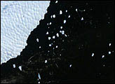
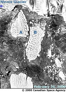 February 20, 2000. By 20 February 2000, Bergs A and B had almost totally separated, rotated counterclockwise, and drifted to the north. Note that both sections are now well away from the Ninnis Glacier.