Chipping Away at the Truth | |||
Answers require data. Through the 1990s, data on weather, climate, and ice had only been collected for short periods of time at widely scattered locations on the ice sheet. The primary goal of Abdalati and his colleagues during their Greenland expeditions was to augment their meager Greenland ice sheet datasets by collecting ground-based and aircraft data that would help them to understand the measurements made by early generations of Earth-monitoring satellites and to figure out what was happening to the ice sheet. He and other researchers set up observation stations on the ice sheet to record when the ice began to melt at particular places, how long the melt lasted, and how much ice melted during this period. |
|||
Abdalati and his colleagues dug shallow snow pits to measure annual snowfall. They set up stations to observe ice movement and to measure how much heat and sunlight was emitted and reflected from the surface. Krabill augmented these on-the-ice studies with aircraft flights that produced laser altimetry maps of how the surface elevation was changing over large parts of the ice sheet and coastal glaciers. These aircraft measurements provided important new insights and helped NASA’s scientists make progress in understanding the behavior of the ice sheet by offering a wider perspective than ground stations. But aircraft only provide snapshots in time of a limited number of regions of the ice sheet. All of these ground and aircraft measurements combined offered only tantalizing glimpses of the enormous ice sheet and could not give Abdalati and his colleagues all the answers they sought. Prior to 2000, there were no observational estimates of Greenland’s ice sheet mass balance. Krabill’s aircraft measurements provided the first ice mass balance estimates in 2000, but scientists needed even more data to understand how representative his estimate was of the longer-term changes of the entire ice sheet. |
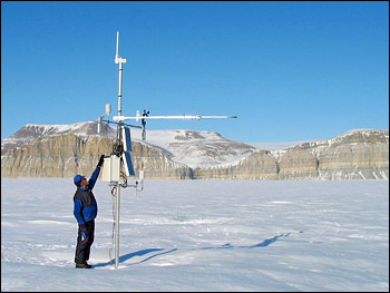
Weather stations on Greenland provide detailed wind, temperature, and precipitation data, but only in limited areas. (NASA photograph courtesy Waleed Abdalati, GSFC.) | ||
 |
It was frustrating to Abdalati to know that the limited information scientists had gave only a glimpse into what was happening on the Greenland ice sheet. It would take many years of these expensive, logistically complicated studies to answer the critical question that drove him to Greenland. Abdalati knew that these studies were just “chipping away at the edges of the major questions with the tools at hand.” |
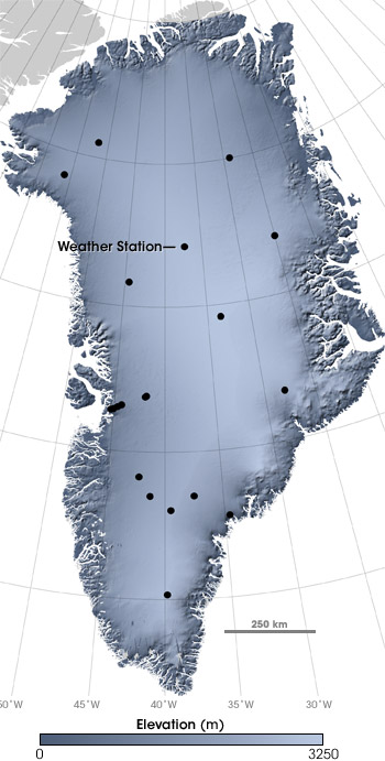
The sparse network of weather stations (locations marked with black dots) scattered across Greenland can’t reveal all the changes that are occurring. Overland expeditions and aircraft overflights expand coverage slightly, but only provide snapshots. Only satellites can provide long-term, continuous observations over the entire surface of the ice sheet. (NASA map by Robert Simmon, based on ICESat data.) | |
